Country:
 Tanzania
Region:
City:
Latitude and Longitude:
Time Zone:
Postal Code:
IP information under different IP Channel
ip-api
Country
Region
City
ASN
Time Zone
ISP
Blacklist
Proxy
Latitude
Longitude
Postal
Route
IPinfo
Country
Region
City
ASN
Time Zone
ISP
Blacklist
Proxy
Latitude
Longitude
Postal
Route
MaxMind
Country
Region
City
ASN
Time Zone
ISP
Blacklist
Proxy
Latitude
Longitude
Postal
Route
Luminati
Country
 LU
LUASN
Time Zone
Europe/Luxembourg
ISP
Ses Astra S.A.
Latitude
Longitude
Postal
db-ip
Country
Region
City
ASN
Time Zone
ISP
Blacklist
Proxy
Latitude
Longitude
Postal
Route
ipdata
Country
Region
City
ASN
Time Zone
ISP
Blacklist
Proxy
Latitude
Longitude
Postal
Route
Popular places and events near this IP address

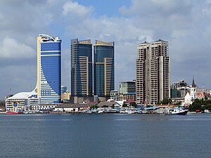
Dar es Salaam
Largest city in Tanzania and capital of Dar es Salaam Region
Distance: Approx. 1347 meters
Latitude and longitude: -6.81611111,39.28027778
Dar es Salaam (; from Arabic: دَار السَّلَام, romanized: Dār as-Salām, lit. 'Abode of Peace') is the largest city and financial hub of Tanzania. It is also the capital of the Dar es Salaam Region. With a population of over five million people, Dar es Salaam is the largest city in East Africa and the sixth-largest in Africa.

Kariakoo
Ward of Ilala District, Dar es Salaam Region
Distance: Approx. 484 meters
Latitude and longitude: -6.8197,39.273
Kariakoo (Kata ya Kariakoo, in Swahili) is an administrative ward of the Ilala Municipical Council of the Dar es Salaam Region in Tanzania. Jangwani ward and Mchafukoge ward form the ward's northern and eastern boundaries. The Gerezani and Mchikichini wards border the ward to the south and west respectively.

Ilala, Ilala District
Ward of the Ilala District in the Dar es Salaam Region of Tanzania
Distance: Approx. 1295 meters
Latitude and longitude: -6.8277,39.2596
Ilala or Ilala Ward (Kata ya Ilala, in Swahili) is an administrative ward of the Ilala District of the Dar es Salaam Region in Tanzania. The Kigogo ward of the Kinondoni District borders the ward to the north, and the Mchikichini and Gerezani wards to the east. The Temeke District wards of Keko, Chang'ombe, and Temeke border the ward to the south.

Jangwani
Ward of Ilala District, Dar es Salaam Region
Distance: Approx. 852 meters
Latitude and longitude: -6.8166,39.2743
Jangwani (Kata ya Jangawani, in Swahili) is an administrative ward of the Ilala Municipical Council of the Dar es Salaam Region in Tanzania. The Upanga East and Upanga West wards border the ward on its northern side. The ward is bordered by Mchafukoge and Kisutu to the east.
Mchafukoge
Ward and district capital of Ilala District, Dar es Salaam Region
Distance: Approx. 1295 meters
Latitude and longitude: -6.8277,39.2596
Mchafukoge (Kata ya Mchafukoge in Swahili) is an administrative ward and district capital of the Ilala district in the Dar es Salaam Region of Tanzania. Kisutu and Kivukoni wards form the ward's northern boundary. The Dar es Salaam Harbor forms its eastern border.

Mchikichini
Ward of Ilala District, Dar es Salaam Region
Distance: Approx. 829 meters
Latitude and longitude: -6.8208,39.2633
Mchikichini (Kata ya Mchikichini, in Swahili) is an administrative ward of the Ilala Municipical Council of the Dar es Salaam Region in Tanzania. Upanga West forms the ward's northern boundary. Its eastern border is formed by Jangwani and Kariakoo.

Dar es Salaam Institute of Technology
Educational institution in Tanzania
Distance: Approx. 1404 meters
Latitude and longitude: -6.81067222,39.26891944
The Dar es Salaam Institute of Technology (DIT) is one of the high learning institutions in Tanzania. Originally established in 1957, it is fully accredited by the National Council for Technical Education (NACTE) to offer technician and engineering programmes leading to the awards of Ordinary Diploma(OD) in engineering, Bachelor of Engineering (BEng) respectively and Master of Engineering(MEng). Historically, DIT was established in 1997 by the Act of Parliament, “the DIT Act No.6 of 1997” to replace the Dar es Salaam Technical College, which had a long history of technical training in Tanzania.
Tanzania Public Service College
Public university in Tanzania
Distance: Approx. 1471 meters
Latitude and longitude: -6.815,39.28083333
The Tanzania Public Service College (TPSC), an institution of higher learning in Tanzania, mandated to offer courses that prepare school leavers for effective delivery of public service to the citizens of the country. The institution also offers refresher courses to active public servants, to improve and update their knowledge-base and skills.

Dar es Salaam commuter rail
Public transit system in Tanzania
Distance: Approx. 874 meters
Latitude and longitude: -6.81629,39.266651
The Dar es Salaam commuter rail, informally known as Treni ya Mwakyembe ("Train of Mwakyembe"), is an urban and suburban commuter rail network serving the Tanzanian commercial city of Dar es Salaam. It is one of the two initiatives taken by the government to ease travel within the congested city; the other being the Dar es Salaam bus rapid transit system. Services are provided by the Tanzania-Zambia Railway Authority (TAZARA) and the Tanzania Railways Corporation (TRC).

Uhuru Monument
Monument in Dar es Salaam, Tanzania
Distance: Approx. 1150 meters
Latitude and longitude: -6.8182,39.2795
The Uhuru Monument (also known as Uhuru Torch Monument) is a landmark monument and tourist attraction located in Mchafukoge ward of Ilala District in Dar es Salaam Region, Tanzania. It is a white obelisk with a replica of the Uhuru Torch mounted at its top. It is located at the Mnazi Mmoja Park in the city centre and is partly fenced.
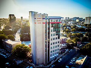
Regency Medical Centre
Hospital in Dar es Salaam, Tanzania
Distance: Approx. 1501 meters
Latitude and longitude: -6.81297222,39.27925
Regency Medical Centre is a multi-specialty hospital located on Aly Khan Road, in Dar es Salaam, Tanzania. Established in 1999, the hospital was founded by Dr. Rajni Kanabar, who was also the hospital's Chairman and the convener of the Tanzania Babies Heart Project till 25 June 2019.
International Commercial Bank Tanzania
Commercial bank in Tanzania
Distance: Approx. 1343 meters
Latitude and longitude: -6.81361111,39.27777778
International Commercial Bank Tanzania Limited (ICBT), is a commercial bank in Tanzania, the third-largest economy in the East African Community. It is licensed by the Bank of Tanzania, the country's central bank and national banking regulator.
Weather in this IP's area
broken clouds
27 Celsius
28 Celsius
27 Celsius
27 Celsius
1018 hPa
58 %
1018 hPa
1016 hPa
10000 meters
3.02 m/s
4.43 m/s
176 degree
63 %
06:35:09
18:23:26