Country:
 Liberia
Region:
City:
Latitude and Longitude:
Time Zone:
Postal Code:
IP information under different IP Channel
ip-api
Country
Region
City
ASN
Time Zone
ISP
Blacklist
Proxy
Latitude
Longitude
Postal
Route
IPinfo
Country
Region
City
ASN
Time Zone
ISP
Blacklist
Proxy
Latitude
Longitude
Postal
Route
MaxMind
Country
Region
City
ASN
Time Zone
ISP
Blacklist
Proxy
Latitude
Longitude
Postal
Route
Luminati
Country
 LU
LUASN
Time Zone
Europe/Luxembourg
ISP
Ses Astra S.A.
Latitude
Longitude
Postal
db-ip
Country
Region
City
ASN
Time Zone
ISP
Blacklist
Proxy
Latitude
Longitude
Postal
Route
ipdata
Country
Region
City
ASN
Time Zone
ISP
Blacklist
Proxy
Latitude
Longitude
Postal
Route
Popular places and events near this IP address
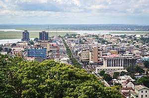
Monrovia
Capital, chief port, and the largest city of Liberia
Distance: Approx. 1499 meters
Latitude and longitude: 6.31333333,-10.80138889
Monrovia () is the capital and largest city of Liberia. Founded in 1822, it is located on Cape Mesurado on the Atlantic coast and as of the 2022 census had 1,761,032 residents, home to 33.5% of Liberia’s total population. Its Metro Area including Montserrado and Margibi counties largely being urbanized, was home to 2,225,911 inhabitants as of the 2022 census.
House of Representatives of Liberia
Lower house of Liberian legislature
Distance: Approx. 144 meters
Latitude and longitude: 6.30166667,-10.79583333
The House of Representatives is the lower chamber of the bicameral legislative branch of Liberia, and together with the Senate comprises the Legislature of Liberia. The number of seats is fixed by law at 73, with each county being apportioned a number of seats based on its percentage of the national population. House members represent single-member districts within the counties drawn up by the National Elections Commission and serve six-year terms.
Greater Monrovia District
Districts located in Montserrado County, Liberia
Distance: Approx. 1411 meters
Latitude and longitude: 6.31055556,-10.80472222
Greater Monrovia is one of four districts located in Montserrado County, Liberia. It contains the country's capital Monrovia. It recorded a population of 970,824 in the 2008 census.
Supreme Court of Liberia
Highest court in Liberia
Distance: Approx. 179 meters
Latitude and longitude: 6.30222222,-10.79722222
The Supreme Court of Liberia is the highest judicial body in Liberia. The court consists of the Chief Justice of Liberia, who is also the top judiciary official, and four associate justices, who are nominated by the President and confirmed by the Senate. The justices hold court at the Temple of Justice on Capitol Hill in Monrovia.

University of Liberia
National university in Liberia
Distance: Approx. 278 meters
Latitude and longitude: 6.29916667,-10.79472222
The University of Liberia (UL or LU in older versions of abbreviation) is a publicly funded institution of higher learning located in Monrovia, Liberia. Authorized by the national government in 1851, the university opened in 1862 as Liberia College. UL has four campuses: the Capitol Hill Campus in Monrovia, the Fendall campus in Louisiana, outside Monrovia, the Medical School Campus in Congo Town, and the Straz-Sinje Campus in Sinje Grand Cape Mount County.
Antoinette Tubman Stadium
Stadium in Liberia
Distance: Approx. 1245 meters
Latitude and longitude: 6.308639,-10.804625
The Antoinette Tubman Stadium (frequently abbreviated ATS Stadium) is a multi-purpose stadium located in Monrovia, Liberia. It is used mostly for football matches although it has also been used for music concerts, major church events, political rallies and Ebola treatment. It has a capacity of 10,000 spectators and is the oldest stadium in Liberia.
Ministry of Foreign Affairs (Liberia)
Foreign ministry of Liberia
Distance: Approx. 249 meters
Latitude and longitude: 6.298492,-10.796313
The Ministry of Foreign Affairs is a cabinet ministry of Liberia responsible for directing Liberia's external relations and the management of its international diplomatic missions. The ministry is located in Monrovia, Liberia's capital.
African Methodist Episcopal University
University in Monrovia, Liberia
Distance: Approx. 1210 meters
Latitude and longitude: 6.3106285,-10.8011504
The African Methodist Episcopal University (AMEU) is a private institution of higher learning located in Monrovia, in the West African nation of Liberia. Located on Camp Johnson Road, the school is the second largest college in Liberia with over 5,000 students. The school was established in 1995 by the African Methodist Episcopal Church, and chartered by the Liberian Legislature in 1996.
Stella Maris Polytechnic University
Private university in Monrovia, Liberia
Distance: Approx. 447 meters
Latitude and longitude: 6.2978,-10.7939
Stella Maris Polytechnic University (SMPU) is a private university in Monrovia, Liberia. Founded in 1988, the school is owned and operated by the Roman Catholic Archdiocese of Monrovia. Located on Capitol Hill, the school has approximately 2,300 students.

Palm Grove Cemetery
Cemetery in Monrovia, Liberia
Distance: Approx. 1581 meters
Latitude and longitude: 6.3114,-10.8061
Palm Grove Cemetery is a cemetery near downtown Monrovia, the capital city of Liberia. During the Tolbert administration, the cemetery became the focus of the national Decoration Day, which continued to be observed after Tolbert was murdered in a 1980 coup d'état and his body dumped at the cemetery. Once the country's national cemetery, it was threatened during June 1982 by Monrovia municipal authorities.

Temple of Justice (Liberia)
Courthouse in Monrovia, Liberia
Distance: Approx. 235 meters
Latitude and longitude: 6.3028,-10.7969
The Temple of Justice is a large building of modern style which was designed by Tommaso Valle in the 1960s on Capitol Hill in Monrovia, Liberia. Dedicated in 1965, it houses the Supreme Court of Liberia, auxiliary courtrooms, and legal offices. It suffered relatively little damage during the First and Second civil wars that lasted from 1989–2003, but poor maintenance and lack of electricity made the Temple unpleasant to work in.

Executive Mansion, Monrovia
Official residence and workplace of the President of Liberia
Distance: Approx. 183 meters
Latitude and longitude: 6.3003,-10.7983
The Executive Mansion of Liberia is the official residence and workplace of the country's president. Located across the street from the Capitol Building in the Capitol Hill district of Monrovia, the current building was constructed during the presidency of William Tubman, which lasted from 1944 to 1971. The construction started in 1961, and was completed in 1964.
Weather in this IP's area
light rain
26 Celsius
27 Celsius
26 Celsius
26 Celsius
1017 hPa
86 %
1017 hPa
1013 hPa
10000 meters
4.41 m/s
5.78 m/s
206 degree
100 %
06:37:22
19:01:45