Country:
 Republic of the Congo
Region:
City:
Latitude and Longitude:
Time Zone:
Postal Code:
IP information under different IP Channel
ip-api
Country
Region
City
ASN
Time Zone
ISP
Blacklist
Proxy
Latitude
Longitude
Postal
Route
IPinfo
Country
Region
City
ASN
Time Zone
ISP
Blacklist
Proxy
Latitude
Longitude
Postal
Route
MaxMind
Country
Region
City
ASN
Time Zone
ISP
Blacklist
Proxy
Latitude
Longitude
Postal
Route
Luminati
Country
 LU
LUASN
Time Zone
Europe/Luxembourg
ISP
Ses Astra S.A.
Latitude
Longitude
Postal
db-ip
Country
Region
City
ASN
Time Zone
ISP
Blacklist
Proxy
Latitude
Longitude
Postal
Route
ipdata
Country
Region
City
ASN
Time Zone
ISP
Blacklist
Proxy
Latitude
Longitude
Postal
Route
Popular places and events near this IP address

Brazzaville
Capital and the largest city of the Republic of the Congo
Distance: Approx. 1440 meters
Latitude and longitude: -4.26944444,15.27111111
Brazzaville (French pronunciation: [bʁazavil], Kongo: Ntamo, Ntambo, Kintamo, Kintambo, Tandala, Mavula; Teke: M'fa, Mfaa, Mfa, Mfoa) is the capital and largest city of the Republic of the Congo (Congo Republic). Administratively, it is a department and a commune. Constituting the financial and administrative centre of the country, it is located on the north side of the Congo River, opposite Kinshasa, the capital city of the Democratic Republic of the Congo (DR Congo).

French Equatorial Africa
Federation of French colonies in central Africa (1910–58)
Distance: Approx. 124 meters
Latitude and longitude: -4.2667,15.2833
French Equatorial Africa (French: Afrique équatoriale française, or AEF) was a federation of French colonial territories in Equatorial Africa which consisted of Gabon, French Congo, Ubangi-Shari, and Chad. It existed from 1910 to 1958 and its administration was based in Brazzaville.

People's Republic of the Congo
1969–1992 socialist state in Central Africa
Distance: Approx. 120 meters
Latitude and longitude: -4.26666667,15.28333333
The People's Republic of the Congo (French: République populaire du Congo) was a Marxist–Leninist socialist state that existed in the Republic of the Congo from 1969 to 1992. The People's Republic of the Congo was founded in December 1969 as the first Marxist-Leninist state in Africa, three months after the government of Alphonse Massamba-Débat was overthrown in the September 1968 coup d'état. The ruling Congolese Party of Labour (French: Parti congolais du travail, PCT) appointed Marien Ngouabi as president, who established the Congo as a one-party communist government aligned with the Soviet Union.
Roman Catholic Archdiocese of Brazzaville
Roman Catholic archdiocese in the Republic of the Congo
Distance: Approx. 1182 meters
Latitude and longitude: -4.2702,15.2739
The Roman Catholic Archdiocese of Brazzaville (Latin: Archidioecesis Brazzapolitana) is the Metropolitan See for the ecclesiastical province of Brazzaville in the Republic of the Congo.
Stade Marchand
Distance: Approx. 3674 meters
Latitude and longitude: -4.27916667,15.25333333
Stade Marchand is a multi-use stadium in Brazzaville, Republic of the Congo. It is used for football matches and serves as the home of Diables Noirs of the Congo Premier League. It has a capacity of 5,000 people.

Nabemba Tower
Office building in Brazzaville, Republic of the Congo
Distance: Approx. 956 meters
Latitude and longitude: -4.27212,15.2891
The Nabemba Tower, also known as Elf Tower, is a high-rise office block in Brazzaville, Republic of the Congo, located directly on the Congo River in the south of the city. At 106 metres and 30 floors it is the tallest building in the Republic of the Congo. It is named after Mont Nabemba, the highest mountain in the country.
Equatorial Congo Airlines
Distance: Approx. 120 meters
Latitude and longitude: -4.26666667,15.28333333
Equatorial Congo Airlines SA, operating as ECAir, is an airline headquartered in Brazzaville; and is the flag carrier of the Republic of the Congo. The airline suspended all operations on 10 October 2016. however it restarted operations in late March 2024.
Brazzaville arms dump blasts
2012 deadly explosions in Congo
Distance: Approx. 2871 meters
Latitude and longitude: -4.2425,15.295
On 4 March 2012, a series of blasts occurred at an army arms dump in Brazzaville, the capital of the Republic of the Congo. At least 300 people were killed by the explosions. Additional bodies were said to be "unfindable." Among the dead were six Chinese workers from a Beijing Construction Engineering Group work site close to the armoury.

2012 Aéro-Service Ilyushin Il-76 crash
Fatal aviation disaster in Brazzaville, Republic of the Congo
Distance: Approx. 2548 meters
Latitude and longitude: -4.25,15.2667
On 30 November 2012, an Ilyushin Il-76 freighter aircraft, operated by the Armenian cargo airline Air Highnesses on behalf of Congolese cargo airline Aéro-Service, crashed on landing at Brazzaville, Republic of the Congo, killing all six occupants and 26 people on the ground. The aircraft was on a domestic flight from Pointe Noire Airport to Maya-Maya Airport and was attempting to land on runway 5L in heavy rain when it clipped high trees about 1,000 metres (3,300 ft; 1,100 yd) from the runway threshold, disintegrating over 500 metres (1,600 ft; 550 yd). The aircraft caught fire and was destroyed, killing all five Armenian crew and an Armenian policeman present on board, as well as 26 local residents, injuring a further 14.
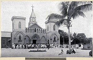
Sacred Heart Cathedral, Brazzaville
Church in Brazzaville, Republic of the Congo
Distance: Approx. 1180 meters
Latitude and longitude: -4.27034,15.27399
The Sacred Heart Cathedral (French: Cathédrale du Sacré-Cœur de Brazzaville) or simply Cathedral of Brazzaville, is a religious building belonging to the Catholic Church and is located in the city of Brazzaville in the African country of the Republic of Congo. The church is the seat of the Bishop of the Archdiocese of Brazzaville and is the oldest existing cathedral in central Africa. The building was built in 1892 and consecrated in 1894.

Basilica of Sainte-Anne-du-Congo in Brazzaville
Distance: Approx. 338 meters
Latitude and longitude: -4.2685,15.2844
The Basilica of Sainte-Anne-du-Congo (French: Basilique Sainte-Anne-du-Congo) is a monumental catholic church in Brazzaville, Republic of the Congo.
2023 Brazzaville crowd crush
Disaster in the Republic of the Congo
Distance: Approx. 2025 meters
Latitude and longitude: -4.26888889,15.26555556
On 21 November, 2023, a crowd crush in Brazzaville, the capital of the Republic of the Congo, occurred on the final day of a military recruitment drive in the Michel d'Ornano Stadium, causing at least 32 deaths and 144 injuries.
Weather in this IP's area
few clouds
26 Celsius
26 Celsius
26 Celsius
26 Celsius
1011 hPa
57 %
1011 hPa
980 hPa
9000 meters
5.14 m/s
240 degree
20 %
06:07:34
18:02:55