Country:
 Czech Republic
Region:
City:
Latitude and Longitude:
Time Zone:
Postal Code:
IP information under different IP Channel
ip-api
Country
Region
City
ASN
Time Zone
ISP
Blacklist
Proxy
Latitude
Longitude
Postal
Route
IPinfo
Country
Region
City
ASN
Time Zone
ISP
Blacklist
Proxy
Latitude
Longitude
Postal
Route
MaxMind
Country
Region
City
ASN
Time Zone
ISP
Blacklist
Proxy
Latitude
Longitude
Postal
Route
Luminati
Country
CZRegion
10
City
prague
ASN
Time Zone
Europe/Prague
ISP
Cato Networks Ltd
Latitude
Longitude
Postal
db-ip
Country
Region
City
ASN
Time Zone
ISP
Blacklist
Proxy
Latitude
Longitude
Postal
Route
ipdata
Country
Region
City
ASN
Time Zone
ISP
Blacklist
Proxy
Latitude
Longitude
Postal
Route
Popular places and events near this IP address
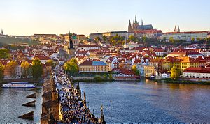
Prague
Capital and largest city of the Czech Republic
Distance: Approx. 61 meters
Latitude and longitude: 50.0875,14.42138889
Prague ( PRAHG; Czech: Praha [ˈpraɦa] ) is the capital and largest city of the Czech Republic and the historical capital of Bohemia. Situated on the Vltava river, Prague is home to about 1.4 million people. The city has a temperate oceanic climate, with relatively warm summers and chilly winters.

Prague astronomical clock
Medieval astronomical clock on the Old Town Hall building in Prague, Czech Republic
Distance: Approx. 100 meters
Latitude and longitude: 50.08700833,14.42091667
The Prague astronomical clock or Prague Orloj (Czech: Pražský orloj [praʃskiː orloj]) is a medieval astronomical clock attached to the Old Town Hall in Prague, the capital of the Czech Republic. The clock was first installed in 1410, making it the third-oldest astronomical clock in the world and the oldest clock still in operation.

Old Town Square
Historic square in Prague, Czech Republic
Distance: Approx. 62 meters
Latitude and longitude: 50.0875,14.4214
Old Town Square (Czech: Staroměstské náměstí [ˈstaroˌmɲɛstskɛː ˈnaːmɲɛsciː] or colloquially Staromák [ˈstaromaːk] ) is a historic square in the Old Town quarter of Prague, the capital of the Czech Republic. It is located between Wenceslas Square and Charles Bridge.
European Association of Archaeologists
Distance: Approx. 61 meters
Latitude and longitude: 50.0875,14.42138889
The European Association of Archaeologists (EAA) is a membership-based, not-for-profit association, open to archaeologists and other related or interested individuals or bodies in Europe and beyond. It was founded in 1994 at an inaugural meeting in Ljubljana, Slovenia, where its Statutes were formally approved, and recognized by the Council of Europe in 1999. EAA has had over 15,000 members on its database from 75 countries.

Jan Hus Memorial
Sculpture in Prague, Czech Republic
Distance: Approx. 26 meters
Latitude and longitude: 50.08777778,14.42111111
The Jan Hus Memorial (Czech: Pomník mistra Jana Husa) stands at one end of Old Town Square, Prague in the Czech Republic. The huge monument depicts victorious Hussite warriors and Protestants who were forced into exile 200 years after Hus in the wake of the lost Battle of the White Mountain during the Thirty Years' War, and a young mother who symbolises national rebirth. The monument was so large that the sculptor designed and built his own villa and studio where the work could be carried out.

Ministry of Regional Development (Czech Republic)
Distance: Approx. 42 meters
Latitude and longitude: 50.08822222,14.42111389
The Ministry of Regional Development of the Czech Republic (Czech: Ministerstvo pro místní rozvoj České republiky) is a government ministry, which was established in 1996.

Kinský Palace (Prague)
Distance: Approx. 64 meters
Latitude and longitude: 50.08805556,14.42166667
Kinský Palace (Czech: Palác Kinských, German: Palais Goltz-Kinsky) is a former palace and now an art museum in Prague, Czech Republic. It is located on the Old Town Square in the Old Town quarter of Prague. The palace's name refers to its former ownership by the Kinsky (Czech: Kinský) noble family.

Old Town Square execution
1621 public execution of leaders of the Bohemian Revolt in Prague
Distance: Approx. 78 meters
Latitude and longitude: 50.0872,14.4209
Old Town Square execution (Czech: Staroměstská exekuce) was the execution of 27 Bohemian leaders (three noblemen, seven knights and 17 burghers) of the Bohemian Revolt by the Austrian House of Habsburg that took place on 21 June 1621 at the Old Town Square in Prague. After the Prague Defenestration in 1618 and subsequent Protestant uprising of the Bohemian estates against the Catholic Habsburgs resulted in the Thirty Years' War and a final defeat in the Battle of White Mountain, Habsburgs took their revenge and executed some of the key leaders of the uprising, although with some others the punishment was reduced and some were pardoned.

Stone Bell House
Distance: Approx. 86 meters
Latitude and longitude: 50.0878,14.422
The Stone Bell House (Czech: Dům U Kamenného zvonu) is located at the Old Town Square in Prague. It is located next to the Kinský Palace, on the corner of Old Town Square and Týnská street.

Old Town Hall (Prague)
Historical building in the Czech Republic
Distance: Approx. 89 meters
Latitude and longitude: 50.0871,14.4207
The Old Town Hall (Czech: Staroměstská radnice) in Prague, the capital of the Czech Republic, is one of the city's most visited monuments. It is located in Old Town Square.
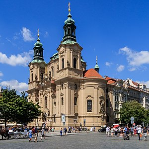
St. Nicholas Church (Staré Město)
Church in Prague, Czech Republic
Distance: Approx. 65 meters
Latitude and longitude: 50.0878,14.4199
The Church of Saint Nicholas (Czech: Kostel svatého Mikuláše) is a Late-Gothic and Baroque church in the Old Town of Prague. It was built between 1732-1737 on the site of a Gothic church from the 13th century which was also dedicated to Saint Nicholas. The church was formerly used by the Czech and Slovak Orthodox Church.

Marian column (Prague)
Column in Prague, Czech Republic
Distance: Approx. 74 meters
Latitude and longitude: 50.0873,14.42125
The Marian column (Czech: Mariánský sloup) of Prague is a religious monument consisting of a column topped with a statue of the Virgin Mary, located in the city's Old Town Square. The original column was erected in 1650, shortly after the conclusion of the Thirty Years' War. It was demolished in November 1918, coinciding with the fall of Austria-Hungary.
Weather in this IP's area
scattered clouds
24 Celsius
24 Celsius
23 Celsius
26 Celsius
1022 hPa
51 %
1022 hPa
999 hPa
10000 meters
6.69 m/s
300 degree
40 %
05:26:04
20:51:19