Country:
 Germany
Region:
City:
Latitude and Longitude:
Time Zone:
Postal Code:
IP information under different IP Channel
ip-api
Country
Region
City
ASN
Time Zone
ISP
Blacklist
Proxy
Latitude
Longitude
Postal
Route
IPinfo
Country
Region
City
ASN
Time Zone
ISP
Blacklist
Proxy
Latitude
Longitude
Postal
Route
MaxMind
Country
Region
City
ASN
Time Zone
ISP
Blacklist
Proxy
Latitude
Longitude
Postal
Route
Luminati
Country
DERegion
by
City
munich
ASN
Time Zone
Europe/Berlin
ISP
Cato Networks Ltd
Latitude
Longitude
Postal
db-ip
Country
Region
City
ASN
Time Zone
ISP
Blacklist
Proxy
Latitude
Longitude
Postal
Route
ipdata
Country
Region
City
ASN
Time Zone
ISP
Blacklist
Proxy
Latitude
Longitude
Postal
Route
Popular places and events near this IP address

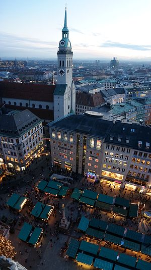
Munich
Capital and most populous city of Bavaria, Germany
Distance: Approx. 39 meters
Latitude and longitude: 48.1375,11.575
Munich ( MEW-nik(h); German: München [ˈmʏnçn̩] ) is the capital and most populous city of the Free State of Bavaria, Germany. With a population of 1,594,632 inhabitants as of 31 May 2024, it is the third-largest city in Germany, after Berlin and Hamburg, and thus the largest which does not constitute its own state, as well as the 11th-largest city in the European Union. The city's metropolitan region is home to about 6.2 million people and the third largest metropolitan region by GDP in the European Union.
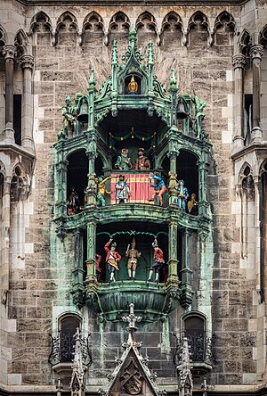
Rathaus-Glockenspiel
Clock in Marienplatz, Munich
Distance: Approx. 12 meters
Latitude and longitude: 48.1375,11.57544
The Rathaus-Glockenspiel is a large mechanical clock located in Marienplatz Square, in the heart of Munich, Germany. Famous for its life-size characters, the clock twice daily re-enacts scenes from Munich's history. First is the story of the marriage of Duke Wilhelm V to Renata of Lorraine in 1568, followed by the story of the Schäfflerstanz, also known as the coopers' dance.
Marienplatz
City square in Munich, Germany
Distance: Approx. 11 meters
Latitude and longitude: 48.1373,11.5755
Marienplatz (English: Mary's Square, i.e. St. Mary, Our Lady's Square) is a central square in the city centre of Munich, Germany.
St. Peter's Church, Munich
Roman Catholic church in Munich, Germany
Distance: Approx. 115 meters
Latitude and longitude: 48.13638889,11.57583333
St. Peter's Church is a Roman Catholic parish church in the inner city of Munich, southern Germany. Its 91-metre (299 ft) tower is commonly known as "Alter Peter"—Old Peter—and is emblematic of Munich.
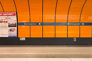
Munich Marienplatz station
Station of the Munich S-Bahn and U-Bahn
Distance: Approx. 26 meters
Latitude and longitude: 48.13722222,11.57527778
Munich Marienplatz is an important stop on the Munich S-Bahn and U-Bahn network, located under the square of the same name in Munich's city centre. The S-Bahn lines , , , , , and intersect with the U-Bahn lines and . The station is one of the most frequently used stations in the network, with up to 24,400 people transferring and 8,000 passengers entering or exiting each hour.
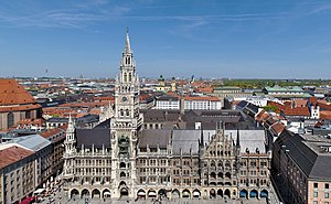
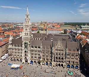
New Town Hall (Munich)
Town hall at the northern part of Marienplatz in Munich, Bavaria, Germany
Distance: Approx. 12 meters
Latitude and longitude: 48.1375,11.57555556
The New Town Hall (German: Neues Rathaus) is a town hall that forms the northern part of Marienplatz in Munich, Bavaria, Germany. It hosts the city government including the city council, offices of the mayors and a small portion of the administration. In 1874 the municipality had left the Old Town Hall for its new domicile.
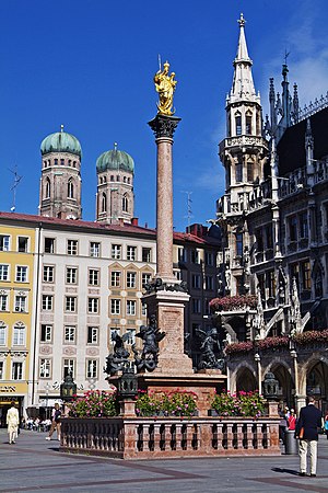
Mariensäule
Marian column in Munich, Bavaria, Germany
Distance: Approx. 22 meters
Latitude and longitude: 48.1372,11.5755
The Mariensäule (lit. 'Mary's Column') is a Marian column located on the Marienplatz in Munich, Germany. Mary is revered here as Patrona Bavariae (Latin: Protector of Bavaria).

Old Town Hall, Munich
City hall in Munich, Germany
Distance: Approx. 135 meters
Latitude and longitude: 48.13666667,11.57694444
The Old Town Hall (German Altes Rathaus), until 1874 the domicile of the municipality, serves today as a building for representative purposes for the city council in Munich, Bavaria, Germany. The Old Town Hall bounds the central square Marienplatz on its east side.

Munich Metropolitan Region
Metropolitan region in Germany
Distance: Approx. 153 meters
Latitude and longitude: 48.1386,11.5765
The Munich Metropolitan Region is one of eleven metropolitan regions in Germany, consisting of the agglomeration areas of Munich, Augsburg, Ingolstadt, Landshut, Rosenheim and Landsberg am Lech. It is Germany's fifth most populous metropolitan region after the Rhine-Ruhr Metropolitan-Region, the Frankfurt Rhine-Main-Region, the Berlin-Brandenburg Metropolitan-Region and the Stuttgart Metropolitan-Region.

Fischbrunnen
Fountain in Munich, Germany
Distance: Approx. 54 meters
Latitude and longitude: 48.13724,11.57619
The Fischbrunnen is a fountain in the center of Munich, whose history can be traced back to the Middle Ages. In 1954, Josef Henselmann created the fountain in its present form, using parts of Konrad Knoll’s neo-gothic fountain that was destroyed during the Second World War.

Rindermarkt
Street in Munich, Germany
Distance: Approx. 137 meters
Latitude and longitude: 48.13626,11.5748
The Rindermarkt is one of the oldest streets in Munich, which connects to the Marienplatz in the north through the former Inner Sendlinger Tor. Its continuation today forms the Sendlinger Straße, which leads to the (outer) Sendlinger Tor. Originally, this street was used as a cattle marketplace, from which the name of the street derives.

Altstadt (Munich)
Distance: Approx. 130 meters
Latitude and longitude: 48.138,11.574
The Munich Old Town is part of the Bavarian capital Munich and has belonged to the city the longest, even if some places which are meanwhile districts of Munich, were mentioned long before Munich's documents spoke of the Old Town. The Old Town forms together with the district Lehel, the municipality No. 1 Altstadt-Lehel.
Weather in this IP's area
broken clouds
27 Celsius
28 Celsius
25 Celsius
28 Celsius
1015 hPa
58 %
1015 hPa
956 hPa
10000 meters
1.34 m/s
4.02 m/s
203 degree
56 %
05:43:18
20:56:52