Country:
 USA
USARegion:
City:
Latitude and Longitude:
Time Zone:
Postal Code:
IP information under different IP Channel
ip-api
Country
Region
City
ASN
Time Zone
ISP
Blacklist
Proxy
Latitude
Longitude
Postal
Route
IPinfo
Country
Region
City
ASN
Time Zone
ISP
Blacklist
Proxy
Latitude
Longitude
Postal
Route
MaxMind
Country
Region
City
ASN
Time Zone
ISP
Blacklist
Proxy
Latitude
Longitude
Postal
Route
Luminati
Country
USASN
Time Zone
America/Chicago
ISP
UNITAS
Latitude
Longitude
Postal
db-ip
Country
Region
City
ASN
Time Zone
ISP
Blacklist
Proxy
Latitude
Longitude
Postal
Route
ipdata
Country
Region
City
ASN
Time Zone
ISP
Blacklist
Proxy
Latitude
Longitude
Postal
Route
Popular places and events near this IP address

Marlborough, Massachusetts
City in Massachusetts, United States
Distance: Approx. 233 meters
Latitude and longitude: 42.34583333,-71.55277778
Marlborough is a city in Middlesex County, Massachusetts, United States. The population was 41,793 at the 2020 census. Marlborough became a prosperous industrial town in the 19th century and made the transition to high technology industry in the late 20th century after the construction of the Massachusetts Turnpike.

Brigham Cemetery
Historic cemetery in Middlesex County, Massachusetts, US
Distance: Approx. 982 meters
Latitude and longitude: 42.34166667,-71.56
Brigham Cemetery is a historic cemetery off West Main Street near Crescent Street in Marlborough, Massachusetts. The small cemetery's first burial was in 1793, and is significant as the city's burial ground for early victims of smallpox. Its burials also include veterans of the American Revolutionary War and the American Civil War.

John Cotting House
Historic house in Massachusetts, United States
Distance: Approx. 338 meters
Latitude and longitude: 42.34694444,-71.54611111
The John Cotting House is a historic house at 74 Main Street in Marlborough, Massachusetts.

Marlborough Center Historic District
Historic district in Massachusetts, United States
Distance: Approx. 126 meters
Latitude and longitude: 42.34777778,-71.54972222
The Marlborough Center Historic District is a historic district encompassing the civic and commercial heart of Marlborough, Massachusetts. It is centered on a stretch of Main Street between Mechanic Street to the west and Bolton Street (Massachusetts Route 85) to the east, and includes properties on adjacent streets. The center is reflective of the city's prosperity as an industrial center from the mid-19th century to the mid-20th century.

Rocklawn Cemetery
Historic cemetery in Massachusetts, United States
Distance: Approx. 1025 meters
Latitude and longitude: 42.35277778,-71.54083333
Rocklawn Cemetery is a historic cemetery on Stevens Street in Marlborough, Massachusetts. Established in 1813 as Chipman Cemetery, it was Marlborough's fifth cemetery. The Rocklawn section of the cemetery was added in 1855, giving the cemetery its present name.

Spring Hill Cemetery (Marlborough, Massachusetts)
Historic site in Middlesex County, Massachusetts, US
Distance: Approx. 607 meters
Latitude and longitude: 42.34805556,-71.54305556
Spring Hill Cemetery is a historic cemetery at High and Brown Streets in Marlborough, Massachusetts. Established in 1675, it is the city's oldest cemetery. It has about 650 known burials, dating from its establishment to 1977.

Temple Building (Marlborough, Massachusetts)
United States historic place
Distance: Approx. 111 meters
Latitude and longitude: 42.34694444,-71.54888889
The Temple Building is a historic commercial and residential building at 149 Main Street in Marlborough, Massachusetts. The four story red brick building was built in 1879–80, and originally housed shops on the ground floor and a hotel on the upper floors. It still has shop space on the ground floor, but the upper levels have been converted to apartments.
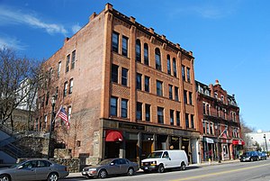
Warren Block (Marlborough, Massachusetts)
United States historic place
Distance: Approx. 111 meters
Latitude and longitude: 42.34694444,-71.54888889
The Warren Block is a historic commercial block at 155 Main Street in Marlborough, Massachusetts. The four-story brick building was built in 1891 for Winslow Warren, owner of the local railway express. The building was designed to house office spaces on most of the first and second floors, and facilities of the local YMCA, including a gymnasium and reading room.

John Brown Bell
Distance: Approx. 397 meters
Latitude and longitude: 42.34747,-71.54549
The John Brown Bell, in Marlborough, Massachusetts, is a distinguished American Civil War-era bell that has been called the "second-most important bell in American history", after the Liberty Bell.
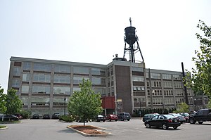
Dennison Manufacturing Co. Paper Box Factory
United States historic place
Distance: Approx. 849 meters
Latitude and longitude: 42.34083333,-71.54361111
The Dennison Manufacturing Co. Paper Box Factory is a historic factory building at 175 Maple Street in Marlborough, Massachusetts. It was built in 1923 and owned by the paper company until 1969.

West Main Street Historic District (Marlborough, Massachusetts)
Historic district in Massachusetts, United States
Distance: Approx. 664 meters
Latitude and longitude: 42.34416667,-71.5575
The West Main Street Historic District of Marlborough, Massachusetts encompasses a residential area west of the city center. It extends along West Main Street from Mechanic Street to Gibbon Street, along Pleasant Street from West Main to Lincoln Street, and also includes short pieces of Witherbee and Winthrop Streets abutting West Main. Most of the buildings in the district are houses built between 1820 and 1930, the period of the city's growth as an industrial center.

Marlborough City Hall (Massachusetts)
The seat of city government of Marlborough, Massachusetts
Distance: Approx. 126 meters
Latitude and longitude: 42.34777778,-71.54972222
Marlborough City Hall is the seat of city government of Marlborough, Massachusetts. It includes the offices of the mayor of Marlborough and the Marlborough City Council. The current city hall building was built in 1905 by architects Allen, Collens and Berry and is an example of Beaux-Arts architecture.
Weather in this IP's area
few clouds
27 Celsius
28 Celsius
25 Celsius
29 Celsius
1018 hPa
53 %
1018 hPa
1005 hPa
10000 meters
0.45 m/s
3.13 m/s
71 degree
21 %
05:35:06
20:10:02