Country:
 USA
USARegion:
City:
Latitude and Longitude:
Time Zone:
Postal Code:
IP information under different IP Channel
ip-api
Country
Region
City
ASN
Time Zone
ISP
Blacklist
Proxy
Latitude
Longitude
Postal
Route
IPinfo
Country
Region
City
ASN
Time Zone
ISP
Blacklist
Proxy
Latitude
Longitude
Postal
Route
MaxMind
Country
Region
City
ASN
Time Zone
ISP
Blacklist
Proxy
Latitude
Longitude
Postal
Route
Luminati
Country
USASN
Time Zone
America/Chicago
ISP
UNITAS
Latitude
Longitude
Postal
db-ip
Country
Region
City
ASN
Time Zone
ISP
Blacklist
Proxy
Latitude
Longitude
Postal
Route
ipdata
Country
Region
City
ASN
Time Zone
ISP
Blacklist
Proxy
Latitude
Longitude
Postal
Route
Popular places and events near this IP address
Becton Regional High School
High school in New Jersey, United States
Distance: Approx. 1071 meters
Latitude and longitude: 40.83257,-74.094149
Becton Regional High School (formally Henry P. Becton Regional High School) is a four-year comprehensive public high school serving students in ninth through twelfth grades from Carlstadt and East Rutherford, in Bergen County, in the U.S. state of New Jersey, operating as part of the Carlstadt-East Rutherford Regional School District. Students from Maywood attend the school as part of a sending/receiving relationship with the Maywood Public Schools. Becton Regional High School is accredited by the New Jersey Department of Education and has been accredited by the Middle States Association of Colleges and Schools since 1938.
WADO
Radio station in New York City
Distance: Approx. 1121 meters
Latitude and longitude: 40.82676667,-74.07514167
WADO (1280 AM) is a commercial radio station licensed to New York, New York. It is owned by Latino Media Network, and broadcasts a Spanish-language sports radio format. By day, WADO is powered at 50,000 watts, the maximum permitted for American AM stations.
Carlstadt-East Rutherford Regional School District
School district in Bergen County, New Jersey, US
Distance: Approx. 1071 meters
Latitude and longitude: 40.83257,-74.094149
The Carlstadt-East Rutherford Regional School District is a regional public high school and school district serving students in ninth through twelfth grades from both Carlstadt and East Rutherford, two relatively small communities in Bergen County, in the U.S. state of New Jersey. Students from Maywood attend the district's high school as part of a sending/receiving relationship. As of the 2022–23 school year, the district, comprised of one school, had an enrollment of 539 students and 45.5 classroom teachers (on an FTE basis), for a student–teacher ratio of 11.9:1.
New Jersey's 9th congressional district
U.S. House district for New Jersey
Distance: Approx. 539 meters
Latitude and longitude: 40.84,-74.08
New Jersey's 9th congressional district is represented in Congress by Democrat Bill Pascrell, who resides in Paterson. Congressman Pascrell was first elected in 1996 from the old 8th district (prior to the 2010 census), defeating incumbent William J. Martini. The 9th district consists largely of municipalities in Bergen County and Passaic County.
East Rutherford School District
School district in Bergen County, New Jersey, US
Distance: Approx. 1480 meters
Latitude and longitude: 40.83495,-74.099559
The East Rutherford School District is a community public school district that serves students in pre-kindergarten through eighth grade from East Rutherford, in Bergen County, in the U.S. state of New Jersey. As of the 2022–23 school year, the district, comprising three schools, had an enrollment of 750 students and 78.9 classroom teachers (on an FTE basis), for a student–teacher ratio of 9.5:1. The district is classified by the New Jersey Department of Education as being in District Factor Group "CD", the sixth-highest of eight groupings.
Carlstadt Public Schools
School district in Bergen County, New Jersey, US
Distance: Approx. 1406 meters
Latitude and longitude: 40.843197,-74.095128
The Carlstadt Public Schools is a community public school district that serves students in pre-kindergarten through eighth grade from the Borough of Carlstadt in Bergen County, in the U.S. state of New Jersey. As of the 2022–23 school year, the district, comprising one school, had an enrollment of 539 students and 45.5 classroom teachers (on an FTE basis), for a student–teacher ratio of 11.9:1. The district is classified by the New Jersey Department of Education as being in District Factor Group "DE", the fifth-highest of eight groupings.
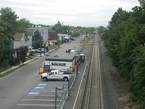
Wood-Ridge station
NJ Transit rail station
Distance: Approx. 960 meters
Latitude and longitude: 40.8437,-74.0789
Wood-Ridge is an active commuter railroad train station in the borough of Wood-Ridge, Bergen County, New Jersey. Located next to the interchange of Route 17 and Moonachie (County Route 36), the single low-level side platform station services trains of New Jersey Transit's Pascack Valley Line between Hoboken Terminal and Spring Valley. The next station to the north is Teterboro and to the south is Secaucus Junction.
Wood-Ridge High School
High school in Bergen County, New Jersey, United States
Distance: Approx. 1461 meters
Latitude and longitude: 40.848495,-74.080791
Wood-Ridge High School is a four-year comprehensive public high school that serves students in seventh through twelfth grade from Wood-Ridge, in Bergen County, in the U.S. state of New Jersey, operating as the lone secondary school of the Wood-Ridge School District. The school was established in 1922. As of the 2022–23 school year, the school had an enrollment of 530 students and 46.4 classroom teachers (on an FTE basis), for a student–teacher ratio of 11.4:1.
New Jersey Music Hall of Fame
Distance: Approx. 1453 meters
Latitude and longitude: 40.824,-74.0736
The New Jersey Music Hall of Fame was founded in 2005 in Asbury Park, New Jersey, with plans to construct a building in downtown Asbury Park or closer to the Boardwalk. New Jersey has a rich musical heritage, covering artists from Count Basie to Frank Sinatra to Bruce Springsteen. New Jersey has also played a role in the technology behind music; Thomas Edison invented the record player in the state in 1877, while Les Paul created the solid-body guitar.
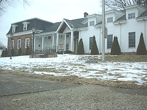
Brinkerhoff House
Historic house in New Jersey, United States
Distance: Approx. 1378 meters
Latitude and longitude: 40.84777778,-74.08222222
The Brinkerhoff House is located in Wood-Ridge, Bergen County, New Jersey, United States. The building was originally constructed in 1792 by George Brinkerhoff. In the 1870s the house was remodeled by Henry E. Brinkerhoff.

Fridolin Arnault House
Historic house in New Jersey, United States
Distance: Approx. 1204 meters
Latitude and longitude: 40.84555556,-74.08693333
The Fridolin Arnault House is located in Wood-Ridge, Bergen County, New Jersey, United States. The house was added to the National Register of Historic Places on December 23, 2009. The Wood-Ridge Historical Society is headquartered in this house.
East Rutherford Operations Center
Regional office of the Federal Reserve Bank of New York
Distance: Approx. 1463 meters
Latitude and longitude: 40.827522,-74.095906
The East Rutherford Operations Center (EROC) at 100 Orchard Street, East Rutherford, New Jersey, is the regional office for cash handling and banknote processing of the Federal Reserve Bank of New York. The facility, which was constructed by Torcon in the early 1990s, features a 400,000-square-foot (37,000 m2) three-story structure which sits on 13 acres. The structure is designed to house fail-safe operations in a secure environment.
Weather in this IP's area
few clouds
23 Celsius
24 Celsius
21 Celsius
24 Celsius
1017 hPa
76 %
1017 hPa
1017 hPa
10000 meters
3.6 m/s
220 degree
20 %
05:49:15
20:16:09