Country:
 USA
USARegion:
City:
Latitude and Longitude:
Time Zone:
Postal Code:
IP information under different IP Channel
ip-api
Country
Region
City
ASN
Time Zone
ISP
Blacklist
Proxy
Latitude
Longitude
Postal
Route
IPinfo
Country
Region
City
ASN
Time Zone
ISP
Blacklist
Proxy
Latitude
Longitude
Postal
Route
MaxMind
Country
Region
City
ASN
Time Zone
ISP
Blacklist
Proxy
Latitude
Longitude
Postal
Route
Luminati
Country
USASN
Time Zone
America/Chicago
ISP
LEXIS-AS
Latitude
Longitude
Postal
db-ip
Country
Region
City
ASN
Time Zone
ISP
Blacklist
Proxy
Latitude
Longitude
Postal
Route
ipdata
Country
Region
City
ASN
Time Zone
ISP
Blacklist
Proxy
Latitude
Longitude
Postal
Route
Popular places and events near this IP address
Miamisburg, Ohio
City in Ohio, United States
Distance: Approx. 655 meters
Latitude and longitude: 39.63055556,-84.26972222
Miamisburg ( my-AM-eez-burg) is a city in southern Montgomery County, Ohio, United States. The population was 19,923 at the 2020 census. A suburb of Dayton, it is part of the Dayton metropolitan area.

Dayton Mall
Shopping mall in Ohio, United States
Distance: Approx. 3574 meters
Latitude and longitude: 39.63395,-84.2206
Dayton Mall is a shopping mall in Miami Township, Montgomery County, Ohio, United States, a suburb of Dayton. The mall's anchor stores are JCPenney and Macy's. Junior anchors are Dick's Sporting Goods, DSW, Guitar Center, H&M, Kirkland's, LensCrafters, Morris Home Furniture, Ross Dress for Less, and Ulta Beauty.

Cox Arboretum and Gardens MetroPark
Botanical garden and park in Dayton, Ohio, United States
Distance: Approx. 3877 meters
Latitude and longitude: 39.65368,-84.22789
The Cox Arboretum and Gardens MetroPark is a 189 acres (76 ha) arboretum and park located at 6733 Springboro Pike, Dayton, Ohio (in Miami Township, south of the city proper). It is open daily without charge. Cox Arboretum and Gardens MetroPark is one of many Dayton area parks within the Five Rivers Metroparks system.

Miamisburg High School
Public school in Miamisburg, Ohio, United States
Distance: Approx. 509 meters
Latitude and longitude: 39.627939,-84.257574
Miamisburg High School is a public high school located in Miamisburg, Ohio, United States, serving grades 9-12. The current principal is Michael Black. It is part of the Miamisburg City School District and is the only high school in Miamisburg.
Miami Township, Montgomery County, Ohio
Civil township in Ohio, United States
Distance: Approx. 667 meters
Latitude and longitude: 39.63444444,-84.25583333
Miami Township is one of the nine townships of Montgomery County, Ohio, United States. The population was 52,156 at the 2020 census.
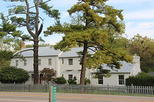
Gebhart Tavern
Museum in Miamisburg, Ohio
Distance: Approx. 2601 meters
Latitude and longitude: 39.638287,-84.290883
Gebhart Tavern, also known as the Daniel Gebhart Tavern Museum, is a small museum located in Miamisburg, Ohio, United States. It is a popular attraction in Miamisburg and is currently being run by the Miamisburg Historical Society.
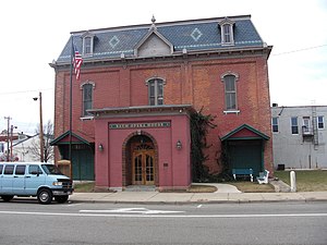
Baum Opera House
Distance: Approx. 2527 meters
Latitude and longitude: 39.6413,-84.2883
Baum Opera House is a historic mansard style opera house located in Miamisburg Ohio, United States. It was built in 1884 by Charles Baum who had originally named it the Star City Opera House. At the time, it was one of the finest opera houses in Ohio.

Mound Laboratories
Distance: Approx. 2084 meters
Latitude and longitude: 39.6291,-84.2863
Mound Laboratory in Miamisburg, Ohio was an Atomic Energy Commission (later Department of Energy) facility for nuclear weapon research during the Cold War, named after the nearby Miamisburg Indian Mound. The laboratory grew out of the World War II era Dayton Project (a site within the Manhattan Project) where the neutron generating triggers for the first plutonium bombs were developed. Post-war construction of a permanent site for Dayton Project activities began in 1947.
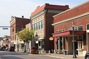
Market Square (Miamisburg, Ohio)
United States historic place
Distance: Approx. 3477 meters
Latitude and longitude: 39.64083333,-84.30055556
Market Square in Miamisburg, Ohio is a square located at the intersection of Central Avenue and Main Street. It is also the name of a 10.4-acre (4.2 ha) historic district including the square and more, that was listed on the National Register of Historic Places in 1975. A date of significance for the location is 1850.

Jacob's Church
Historic church in Ohio, United States
Distance: Approx. 2418 meters
Latitude and longitude: 39.64194444,-84.28638889
Jacob's Church (St. Jacob's Evangelical Lutheran Church) is a historic Lutheran church at 213 E. Central Avenue in Miamisburg, Ohio. It was built in 1864 and added to the National Register in 1990.
1986 Miamisburg train derailment
1986 disaster in Ohio
Distance: Approx. 3190 meters
Latitude and longitude: 39.65105897,-84.28854055
At 4:25 pm on July 8, 1986, a 44 car Baltimore and Ohio railroad freight train, traveling at 45 miles per hour, bound south to Cincinnati, derailed near Miamisburg, Ohio, a small city with an industrial history in Montgomery County, southwest of Dayton. Fifteen of the cars derailed on a bridge; these were tank cars containing yellow phosphorus, molten sulfur and tallow. Carrying a chemical used to make rat poison, fireworks and luminescent coatings, one tank car caught fire.
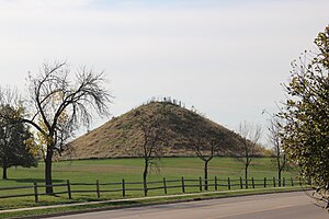
Miamisburg Mound
Archaeological site in Ohio, United States
Distance: Approx. 1653 meters
Latitude and longitude: 39.6276,-84.280896
Miamisburg Mound is a conical Native American Mound in Miamisburg, Ohio. At 65 feet (20 m) tall and 800 feet (240 m) in circumference, it is the largest burial mound in the Eastern United States. Built atop a hill overlooking the Miami River, it is believed to have been built by the Adena Culture between 800BC and 100AD. An excavation in 1869 unearthed several skeletons surrounded by clay and charcoal and a collection of ceremonial goods, including pipes and animal effigies.
Weather in this IP's area
clear sky
29 Celsius
29 Celsius
28 Celsius
31 Celsius
1018 hPa
41 %
1018 hPa
987 hPa
10000 meters
3.09 m/s
160 degree
06:32:09
20:54:43