Country:
 USA
USARegion:
City:
Latitude and Longitude:
Time Zone:
Postal Code:
IP information under different IP Channel
ip-api
Country
Region
City
ASN
Time Zone
ISP
Blacklist
Proxy
Latitude
Longitude
Postal
Route
IPinfo
Country
Region
City
ASN
Time Zone
ISP
Blacklist
Proxy
Latitude
Longitude
Postal
Route
MaxMind
Country
Region
City
ASN
Time Zone
ISP
Blacklist
Proxy
Latitude
Longitude
Postal
Route
Luminati
Country
USASN
Time Zone
America/Chicago
ISP
UNITAS
Latitude
Longitude
Postal
db-ip
Country
Region
City
ASN
Time Zone
ISP
Blacklist
Proxy
Latitude
Longitude
Postal
Route
ipdata
Country
Region
City
ASN
Time Zone
ISP
Blacklist
Proxy
Latitude
Longitude
Postal
Route
Popular places and events near this IP address

Hubba Hideout
Former public location used for skateboarding
Distance: Approx. 236 meters
Latitude and longitude: 37.795632,-122.397826
Hubba Hideout was one of the most famous skateboarding spots. It was located in San Francisco near the Justin Herman Plaza on The Embarcadero. Its central features were two oversized sets of 6 stairs with large concrete ledges on both sides.

Punch Line San Francisco
Comedy club in San Francisco
Distance: Approx. 231 meters
Latitude and longitude: 37.795539,-122.399965
Punch Line San Francisco is a comedy club located at 444 Battery St in San Francisco's Financial District. It has a sister club in Sacramento, California, and is also associated with Cobb's Comedy Club, now in the North Beach neighborhood of San Francisco. It is San Francisco's oldest running comedy club.

One Maritime Plaza
Office tower in San Francisco's Financial District
Distance: Approx. 217 meters
Latitude and longitude: 37.79555556,-122.39916667
One Maritime Plaza is an office tower located in San Francisco's Financial District near the Embarcadero Center towers on Clay and Front Streets. The building, built as the Alcoa Building for Alcoa Corporation and completed in 1967, stands 121 m (398 feet) and has 25 floors of office space. The surrounding plaza was finished in 1967.
Eureka Theatre Company
Theatre company in San Francisco, California
Distance: Approx. 138 meters
Latitude and longitude: 37.79642,-122.39988
The Eureka Theatre Company was an American repertory theatre group located in San Francisco, California. It was founded in 1972 as the Shorter Players by Chris Silva, Robert Woodruff and Carl Lumbly. In 1974 its name was changed to the Eureka Theatre.

The Embarcadero and Broadway station
Distance: Approx. 229 meters
Latitude and longitude: 37.79921,-122.39766
The Embarcadero and Broadway station is a light rail station in San Francisco, California, serving the San Francisco Municipal Railway's E Embarcadero and F Market & Wharves heritage railway lines. It is located on The Embarcadero at Broadway. The station opened on March 4, 2000, with the streetcar's extension to Fisherman's Wharf.

United States Customhouse (San Francisco)
United States historic place
Distance: Approx. 209 meters
Latitude and longitude: 37.79631,-122.400937
The U.S. Customhouse is a historic custom house located in San Francisco, California. It was built to house offices of the United States Customs Service.
Saybrook University
Private university in Pasadena, California
Distance: Approx. 133 meters
Latitude and longitude: 37.7984,-122.4001
Saybrook University is a private university in Pasadena, California. It was founded in 1971 by Eleanor Camp Criswell and others. It offers postgraduate education with a focus on humanistic psychology.
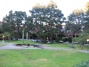
Sydney Walton Square
Distance: Approx. 7 meters
Latitude and longitude: 37.79751,-122.39902
Sydney Walton Square is a public park located just west of the Embarcadero in San Francisco, California, United States. The park is named after San Francisco banker Sydney Grant Walton. The 2-acre park was designed by Peter Walker.
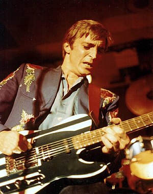
Old Waldorf
Distance: Approx. 247 meters
Latitude and longitude: 37.79536111,-122.39983333
Old Waldorf was a music venue located in San Francisco, California. The famous club was located at 444 Battery St, and was originally opened by Jeffrey Pollack in 1976 before selling it to Bill Graham who closed it in 1983. During its time Old Waldorf hosted some of the biggest names in the music industry, such as Warren Zevon, AC/DC, Devo, Dire Straits, Blue Öyster Cult, Iggy Pop, Blondie, Rory Gallagher, Cheap Trick, Metallica, Pat Benatar, Journey, R.E.M., Television, Spirit, Poco, Afrika Bambaataa, Gary Moore, U2, Dead Kennedys, Albert King, The Tubes, Elvin Bishop, Les Paul, Peter Tosh and many more The Punch Line comedy club now occupies part of Old Waldorf's location.

Sue Bierman Park
Park in San Francisco, United States of America
Distance: Approx. 193 meters
Latitude and longitude: 37.796246,-122.39759
Sue Bierman Park, also known as Ferry Park, is a park in San Francisco, California in the Financial District. Sue Bierman Park replaced off-ramps just north of the Embarcadero Center, and next to the park Ferry Plaza was constructed in front of the San Francisco Ferry Building, which itself was remodeled into an upscale gourmet marketplace in 2003. The park is named after Sue Bierman, a San Francisco civic activist and Supervisor.

Clarks Point (San Francisco)
Cape in San Francisco, United States of America
Distance: Approx. 216 meters
Latitude and longitude: 37.79861111,-122.40111111
Clarks Point was a cape on the north side of Yerba Buena Cove in what is now San Francisco, California. Its former Spanish name was Punta Del Embarcadera. During the California Gold Rush the Clarks Point and the Cove was filled in to form the Embarcadero on San Francisco Bay.
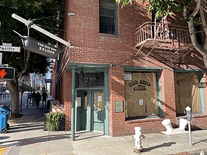
The Old Ship Saloon
Building in San Francisco, California
Distance: Approx. 173 meters
Latitude and longitude: 37.7984,-122.4007
The Old Ship Saloon, formerly the Old Ship Alehouse, is a historic bar dating back to 1851 and the California gold rush when it operated out of the side of a ship run aground until the wreckage was buried and the current structure was built on top of it. It is located at 298 Pacific Avenue in the Jackson Square neighborhood of San Francisco. The Old Ship Saloon is listed as a stop along the Barbary Coast Trail.
Weather in this IP's area
few clouds
15 Celsius
15 Celsius
13 Celsius
20 Celsius
1014 hPa
84 %
1014 hPa
1013 hPa
10000 meters
8.75 m/s
13.38 m/s
290 degree
20 %
06:10:06
20:21:50