Country:
 Australia
Region:
City:
Latitude and Longitude:
Time Zone:
Postal Code:
IP information under different IP Channel
ip-api
Country
Region
City
ASN
Time Zone
ISP
Blacklist
Proxy
Latitude
Longitude
Postal
Route
IPinfo
Country
Region
City
ASN
Time Zone
ISP
Blacklist
Proxy
Latitude
Longitude
Postal
Route
MaxMind
Country
Region
City
ASN
Time Zone
ISP
Blacklist
Proxy
Latitude
Longitude
Postal
Route
Luminati
Country
 HK
HKASN
Time Zone
Asia/Hong_Kong
ISP
Diligent Board Services Australia Pty Ltd
Latitude
Longitude
Postal
db-ip
Country
Region
City
ASN
Time Zone
ISP
Blacklist
Proxy
Latitude
Longitude
Postal
Route
ipdata
Country
Region
City
ASN
Time Zone
ISP
Blacklist
Proxy
Latitude
Longitude
Postal
Route
Popular places and events near this IP address

Ryde, New South Wales
Suburb of Sydney, New South Wales, Australia
Distance: Approx. 208 meters
Latitude and longitude: -33.81527778,151.10111111
Ryde is a suburb of Sydney, New South Wales, Australia. Ryde is located 13 km north-west of the Sydney central business district and 8 km east of Parramatta. Ryde is the administrative centre of the local government area of the City of Ryde and part of the Northern Sydney region.

Meadowbank railway station, Sydney
Railway station in Sydney, New South Wales, Australia
Distance: Approx. 906 meters
Latitude and longitude: -33.816357,151.090019
Meadowbank railway station is located on the Main Northern line, serving the Sydney suburb of Meadowbank. It is served by Sydney Trains T9 Northern Line services.
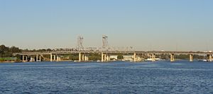
Ryde Bridge
Bridges across the Parramatta River in Sydney, Australia
Distance: Approx. 862 meters
Latitude and longitude: -33.823492,151.095121
The Ryde Bridge, also called the Uhrs Point Bridge, are two road bridges that carry Concord Road, part of the A3, across Parramatta River from Ryde in the northern suburbs of Sydney to Rhodes in Sydney's inner west, in New South Wales, Australia. The two bridges comprise a heritage-listed steel Pratt truss bridge with inoperable lift span that carries three lanes of northbound vehicular traffic plus a grade-separated pedestrian footpath, completed in 1935; and a reinforced concrete fixed-span bridge that carries three lanes of southbound vehicular traffic, completed in 1988.

City of Ryde
Local government area in New South Wales, Australia
Distance: Approx. 24 meters
Latitude and longitude: -33.81666667,151.1
The City of Ryde is a local government area in the Northern Sydney region, in New South Wales, Australia. It was first established as the Municipal District of Ryde in 1870, became a municipality in 1906 and was proclaimed as the City of Ryde in 1992. The local government area extends from the Parramatta River to the Lane Cove River which encircles the area in the north, and is bounded in the east by the peninsula of Hunters Hill and the City of Parramatta in the west.

Meadowbank ferry wharf
Sydney Ferries ferry wharf
Distance: Approx. 1038 meters
Latitude and longitude: -33.82114722,151.08986667
Meadowbank ferry wharf is located on the northern side of the Parramatta River serving the Sydney suburb of Meadowbank.

Top Ryde City
Shopping mall in New South Wales, Australia
Distance: Approx. 772 meters
Latitude and longitude: -33.812182,151.1060215
Top Ryde City (previously known as Top Ryde Shopping Centre) is a large indoor/outdoor shopping centre owned by The Blackstone Group. It is located in the suburb of Ryde in Northern Sydney.

Willandra, Ryde
Heritage listed homestead in New South Wales, Australia
Distance: Approx. 231 meters
Latitude and longitude: -33.816,151.1021
Willandra is a heritage-listed former service station and homestead and now community facility located at 782 Victoria Road, Ryde, New South Wales, Australia. Its design is attributed to William Weaver: 47 and built from 1841 to 1844 by James Devlin. It is also known as the Ryde House.
Marsden High School
School in West Ryde, New South Wales, Australia
Distance: Approx. 766 meters
Latitude and longitude: -33.813,151.09288889
Marsden High School (MHS) is a school located in Meadowbank, New South Wales, Australia. It is a co-educational high school operated by the New South Wales Department of Education with students from years 7 to 12. The school was established in 1959.

Ryde Pumping Station
Historic site in New South Wales, Australia
Distance: Approx. 1119 meters
Latitude and longitude: -33.8099,151.091
The Ryde Pumping Station is a heritage-listed pumping station and offices located at Victoria Road, West Ryde, New South Wales, Australia. It was built from 1891 to 1921 by William Adams & Co. Ltd., State Monier Works, Refshaw & O'Brien.
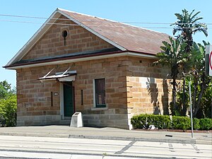
Ryde police station
Historic site in New South Wales, Australia
Distance: Approx. 135 meters
Latitude and longitude: -33.8156,151.1
The Ryde police station is a heritage-listed lockup, police residence and police station located at 808-810 Victoria Road, Ryde in the City of Ryde local government area of New South Wales, Australia. It was designed by Mortimer Lewis and built from 1836 to 1837 by David Taylor; Messrs Brodie & Craig. It is also known as Ryde Police Station (former), Ryde Police Station, Ryde Detective's Offices and Kissing Point Police Watch House or lockup.

Addington House
Historic site in New South Wales, Australia
Distance: Approx. 279 meters
Latitude and longitude: -33.8145,151.0986
Addington House is a heritage-listed former farm, residence and orchard and now community facility located at 813 Victoria Road, Ryde, New South Wales, Australia. It was built from 1794 to 1841 in different stages by James Stewart, James Shepherd, Thomas Bowden. It is also known as New Farm.

The Retreat, Ryde
Historic site in New South Wales, Australia
Distance: Approx. 311 meters
Latitude and longitude: -33.8143,151.0983
The Retreat is a heritage-listed cottage at 817 Victoria Road, Ryde in the City of Ryde local government area of New South Wales, Australia. It was built during 1843 by Isaac Shepherd. It was added to the New South Wales State Heritage Register on 2 April 1999.
Weather in this IP's area
clear sky
8 Celsius
3 Celsius
6 Celsius
9 Celsius
1022 hPa
61 %
1022 hPa
1017 hPa
10000 meters
9.26 m/s
250 degree
7 %
06:50:12
17:13:44