Country:
 Australia
Region:
City:
Latitude and Longitude:
Time Zone:
Postal Code:
IP information under different IP Channel
ip-api
Country
Region
City
ASN
Time Zone
ISP
Blacklist
Proxy
Latitude
Longitude
Postal
Route
IPinfo
Country
Region
City
ASN
Time Zone
ISP
Blacklist
Proxy
Latitude
Longitude
Postal
Route
MaxMind
Country
Region
City
ASN
Time Zone
ISP
Blacklist
Proxy
Latitude
Longitude
Postal
Route
Luminati
Country
 HK
HKASN
Time Zone
Asia/Hong_Kong
ISP
UNITAS
Latitude
Longitude
Postal
db-ip
Country
Region
City
ASN
Time Zone
ISP
Blacklist
Proxy
Latitude
Longitude
Postal
Route
ipdata
Country
Region
City
ASN
Time Zone
ISP
Blacklist
Proxy
Latitude
Longitude
Postal
Route
Popular places and events near this IP address

Western Australian School of Mines
School in Western Australia, Australia
Distance: Approx. 266 meters
Latitude and longitude: -30.74849,121.47413
Western Australian School of Mines (WASM) was founded in 1902 as the Kalgoorlie School of Mines It was a tertiary school specialising in subjects directly related to the Western Australian mining industry. Originally located in Coolgardie, WASM later moved to Kalgoorlie and continued to be primarily funded from independent sources. In 1969 the Department of Mines transferred management of WASM to Western Australian Institute of Technology which later became Curtin University.

Kalgoorlie railway station
Railway station in Kalgoorlie, Western Australia
Distance: Approx. 698 meters
Latitude and longitude: -30.746,121.4669
Kalgoorlie railway station is the easternmost attended station in Western Australia, located at the eastern terminus of the Eastern Goldfields Railway. It serves the city of Kalgoorlie. Beyond Kalgoorlie, the line continues east as the Trans-Australian Railway.
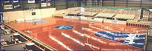
Niels Hansen Basketball Stadium
Sports venue in Kalgoorlie, Western Australia
Distance: Approx. 480 meters
Latitude and longitude: -30.74194444,121.47555556
Niels Hansen Basketball Stadium is a purpose-built basketball stadium located in Kalgoorlie, Western Australia. It is the home of the Kalgoorlie-Boulder Basketball Association (KBBA) and the Goldfields Giants. The stadium is named after local Goldfields basketball stalwart, Niels Hansen.
Eastern Goldfields College
Public co-educational high day school in Kalgoorlie, Western Australia, Australia
Distance: Approx. 573 meters
Latitude and longitude: -30.751233,121.474627
Eastern Goldfields College is a public co-educational high day school, located in Kalgoorlie, Western Australia. It is located on the Curtin University campus in Kalgoorlie and shares many facilities with the University. The College accepts year 11 and 12 students from across the Goldfields region.
Anglican Diocese of Kalgoorlie
Anglican diocese in Western Australia
Distance: Approx. 191 meters
Latitude and longitude: -30.74469444,121.47305556
The Diocese of Kalgoorlie was a diocese of the Church of England in Australia (now the Anglican Church of Australia). It covered much of the Goldfields-Esperance region in Western Australia, and existed from the consecration of its first bishop in 1914 until its re-absorption back into the Anglican Diocese of Perth in 1973. At that point the Kalgoorlie diocese was reported to contain only eight parishes, and was financially unviable as a separate entity.

Kalgoorlie (suburb)
Suburb of Kalgoorlie, Western Australia
Distance: Approx. 848 meters
Latitude and longitude: -30.749,121.466
Kalgoorlie is the central suburb of the Kalgoorlie–Boulder metropolitan area in the Goldfields–Esperance region of Western Australia.

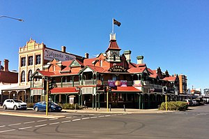
Palace Hotel, Kalgoorlie
Hotel in Kalgoorlie, Western Australia
Distance: Approx. 35 meters
Latitude and longitude: -30.7464,121.4743
The Palace Hotel is one of a group of heritage hotels on Hannan Street in Kalgoorlie, Western Australia.
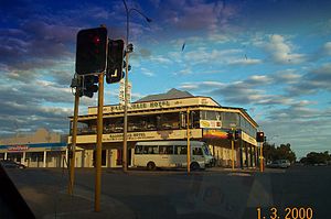
Exchange Hotel, Kalgoorlie
Historic hotel building in Kalgoorlie, Western Australia
Distance: Approx. 49 meters
Latitude and longitude: -30.746,121.4747
For other hotels named Exchange Hotel, see Exchange Hotel. The Exchange Hotel is a historic landmark hotel in Kalgoorlie, Western Australia.

York Hotel, Kalgoorlie
Hotel in Kalgoorlie, Western Australia
Distance: Approx. 319 meters
Latitude and longitude: -30.74828,121.47204
The York Hotel is a heritage hotel on Hannan Street, in Kalgoorlie, Western Australia.
Kalgoorlie Hotel
Hotel on Hannan Street, Kalgoorlie, Western Australia
Distance: Approx. 468 meters
Latitude and longitude: -30.7492,121.4709
The Kalgoorlie Hotel is a historic hotel in Kalgoorlie, Western Australia.
Sir Richard Moore Oval
Sports venue in Kalgoorlie, Western Australia
Distance: Approx. 686 meters
Latitude and longitude: -30.74268389,121.46822611
Sir Richard Moore Oval, also known as Kalgoorlie Oval, is a sports venue in Kalgoorlie, Western Australia used primarily for Australian rules football. The ground formerly hosted cricket. The ground has hosted several West Australian State Premiership matches.
Williamstown, Western Australia
Suburb of Kalgoorlie–Boulder, Western Australia
Distance: Approx. 639 meters
Latitude and longitude: -30.74473,121.48069
Williamstown is a mixed-use suburb of Kalgoorlie–Boulder, a city in the Eastern Goldfields region of Western Australia. It is located to the east of the main Kalgoorlie townsite, and is separated from other residential areas by the Goldfields Highway. It contains the Mount Charlotte Gold Mine.
Weather in this IP's area
clear sky
9 Celsius
7 Celsius
9 Celsius
9 Celsius
1019 hPa
61 %
1019 hPa
972 hPa
10000 meters
3.6 m/s
360 degree
06:42:50
17:18:06