Country:
 Costa Rica
Region:
City:
Latitude and Longitude:
Time Zone:
Postal Code:
IP information under different IP Channel
ip-api
Country
Region
City
ASN
Time Zone
ISP
Blacklist
Proxy
Latitude
Longitude
Postal
Route
IPinfo
Country
Region
City
ASN
Time Zone
ISP
Blacklist
Proxy
Latitude
Longitude
Postal
Route
MaxMind
Country
Region
City
ASN
Time Zone
ISP
Blacklist
Proxy
Latitude
Longitude
Postal
Route
Luminati
Country
CRRegion
sj
City
sanjose
ASN
Time Zone
America/Costa_Rica
ISP
Instituto Costarricense de Electricidad y Telecom.
Latitude
Longitude
Postal
db-ip
Country
Region
City
ASN
Time Zone
ISP
Blacklist
Proxy
Latitude
Longitude
Postal
Route
ipdata
Country
Region
City
ASN
Time Zone
ISP
Blacklist
Proxy
Latitude
Longitude
Postal
Route
Popular places and events near this IP address
Cartago, Costa Rica
City in Cartago Province, Costa Rica
Distance: Approx. 49 meters
Latitude and longitude: 9.86666667,-83.91666667
Cartago (Spanish pronunciation: [kaɾˈtaɣo]) is the head city of Cartago canton of the Cartago Province, and is composed of the Oriental and Occidental districts as stated in the administrative divisions of Costa Rica. It was the capital of Costa Rica from 1574 to 1824.
Costa Rica Institute of Technology
University in Costa Rica
Distance: Approx. 1625 meters
Latitude and longitude: 9.85455556,-83.90902778
The Costa Rica Institute of Technology (TEC) (Spanish: Tecnológico de Costa Rica) is a university in Costa Rica specializing in engineering and advanced science and research, modeled as an institute of technology. Its main campus is located in the Dulce Nombre district of Cartago canton in the Cartago Province of Costa Rica, 24 km (15 mi) east of the capital San José. The TEC is a national autonomous institution of higher education, dedicated to teaching, research and extension in technology and associated sciences.

Estadio José Rafael Fello Meza Ivankovich
Multi-use stadium in Cartago, Costa Rica
Distance: Approx. 988 meters
Latitude and longitude: 9.8584718,-83.9187133
Estadio Jose Rafael "Fello" Meza Ivankovich is a multi-use stadium in Cartago, Costa Rica. It is currently used mostly for football matches and is the home stadium of C.S. Cartaginés. The stadium holds 8350 people and was built in 1949.

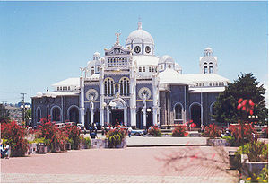
Basilica of Our Lady of the Angels, Cartago
Distance: Approx. 551 meters
Latitude and longitude: 9.86388889,-83.91277778
The Basílica de Nuestra Señora de los Ángeles (Our Lady of the Angels Basilica) is a Roman Catholic basilica in Costa Rica, located in the city of Cartago and dedicated to the Virgen de los Pardos, officially known as Virgen de los Ángeles (the Lady of the Angels). The basilica was built in 1639 and was partially destroyed by an earthquake. The basilica has since been restored and constitutes a unique mix of colonial architecture as well as 19th-century Byzantine style; the current building dates back to 1939.
Roman Catholic Diocese of Cartago in Costa Rica
Latin Catholic ecclesiastical jurisdiction in Costa Rica
Distance: Approx. 650 meters
Latitude and longitude: 9.8652,-83.9222
The Diocese of Cartago (Latin: Dioecesis Carthaginensis in Costa Rica) is a Latin Church ecclesiastical territory or diocese of the Catholic Church in Costa Rica. The Diocese of Cartago in Costa Rica is a suffragan diocese in the ecclesiastical province covering all Costa Rica of the metropolitan Archdiocese of San José de Costa Rica . Its cathedral episcopal see is the Catedral de Nuestra Señora de El Carmen, dedicated to Our Lady of Carmel, in Cartago, Cartago province, central Costa Rica.

Lankester Botanical Garden
Distance: Approx. 4266 meters
Latitude and longitude: 9.83888889,-83.89027778
The Lankester Botanical Gardens (also known as the Jardín Botánico Lankester or Charles H. Lankester Botanical Garden) are a set of gardens outside of Cartago, Costa Rica. The garden is open to the public, but is operated by the University of Costa Rica (UCR) as a research center and is a major center for orchid research in both Central America and the Caribbean.
Hospital Max Peralta
Hospital in Cartago Province, Costa Rica
Distance: Approx. 846 meters
Latitude and longitude: 9.8614,-83.9217
Hospital Max Peralta is a hospital in Cartago, Costa Rica. It is named after Dr. Maximiliano Peralta Jimenez who graduated from Jefferson Medical College (now Sidney Kimmel Medical College, Thomas Jefferson University) in Philadelphia in 1894.
Llanos de Santa Lucía
District in Paraíso canton, Cartago province, Costa Rica
Distance: Approx. 4420 meters
Latitude and longitude: 9.8481479,-83.8811829
Llanos de Santa Lucía formerly known as Santa Lucía is the youngest of the districts of the Paraíso canton, in the Cartago province of Costa Rica. It was established as the fifth district on 21 July 2004.
Oriental District
District in Cartago canton, Cartago province, Costa Rica
Distance: Approx. 701 meters
Latitude and longitude: 9.8609457,-83.9152618
Oriental is a district of the Cartago canton, in the Cartago province of Costa Rica.
Occidental District
District in Cartago canton, Cartago province, Costa Rica
Distance: Approx. 1316 meters
Latitude and longitude: 9.8626528,-83.927722
Occidental is a district of the Cartago canton, in the Cartago province of Costa Rica.
Carmen District, Cartago
District in Cartago province, Costa Rica
Distance: Approx. 1606 meters
Latitude and longitude: 9.8814997,-83.9157244
Carmen is a district of the Cartago canton, in the Cartago province of Costa Rica.
San Rafael District, Oreamuno
District in Oreamuno canton, Cartago province, Costa Rica
Distance: Approx. 2380 meters
Latitude and longitude: 9.8701713,-83.8951285
San Rafael is a district of the Oreamuno canton, in the Cartago province of Costa Rica.
Weather in this IP's area
overcast clouds
21 Celsius
22 Celsius
20 Celsius
21 Celsius
1014 hPa
92 %
1014 hPa
859 hPa
6605 meters
1.42 m/s
2.71 m/s
61 degree
87 %
05:24:52
17:59:12