Country:
 Colombia
Region:
City:
Latitude and Longitude:
Time Zone:
Postal Code:
IP information under different IP Channel
ip-api
Country
Region
City
ASN
Time Zone
ISP
Blacklist
Proxy
Latitude
Longitude
Postal
Route
IPinfo
Country
Region
City
ASN
Time Zone
ISP
Blacklist
Proxy
Latitude
Longitude
Postal
Route
MaxMind
Country
Region
City
ASN
Time Zone
ISP
Blacklist
Proxy
Latitude
Longitude
Postal
Route
Luminati
Country
CORegion
dc
City
bogota
ASN
Time Zone
America/Bogota
ISP
Ses Astra S.A.
Latitude
Longitude
Postal
db-ip
Country
Region
City
ASN
Time Zone
ISP
Blacklist
Proxy
Latitude
Longitude
Postal
Route
ipdata
Country
Region
City
ASN
Time Zone
ISP
Blacklist
Proxy
Latitude
Longitude
Postal
Route
Popular places and events near this IP address

Administrative Department of Security
Law enforcement agency
Distance: Approx. 857 meters
Latitude and longitude: 4.615,-74.0873
The Administrative Department of Security (Spanish: Departamento Administrativo de Seguridad, DAS) was the security service agency of Colombia, which was also responsible for border and immigration services. It was dissolved on 31 October 2011 as part of a wider Executive Reform, and was replaced by the Dirección Nacional de Inteligencia (DNI).

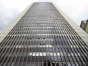
Torre Colpatria
Office skyscraper in Bogotá, Colombia
Distance: Approx. 1275 meters
Latitude and longitude: 4.61104,-74.070288
The Torre Colpatria (English: Colpatria Tower) is a 50-story skyscraper in the downtown area of Bogotá, Colombia. It is the fourth tallest building in the country. Constructed from 1973 to 1978 and opened in 1979, it has a total height of 196 metres (643 ft), becoming the tallest skyscraper of Colombia and holding that title until 2016, when the south tower of the BD Bacatá was topped off.
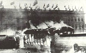
Bogotazo
1948 riots in Bogotá, Colombia over the assassination of pres. candidate Jorge Eliécer Gaitán
Distance: Approx. 1327 meters
Latitude and longitude: 4.6005,-74.0741
El Bogotazo (from "Bogotá" and the -azo suffix of violent augmentation) was a massive outbreak of rioting after the assassination in Bogotá, Colombia of Liberal leader and presidential candidate Jorge Eliécer Gaitán on 9 April 1948 during the government of President Mariano Ospina Pérez. The 10-hour riot left much of downtown Bogotá destroyed. The aftershock of Gaitan's murder continued extending through the countryside and escalated a period of violence which had begun eighteen years before, in 1930, and was triggered by the fall of the conservative party from government and the rise of the liberals.
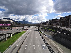
Norte-Quito-Sur
Distance: Approx. 1135 meters
Latitude and longitude: 4.61861111,-74.08666667
Avenida Norte-Quito-Sur or NQS is an arterial road in Bogotá, Colombia that crosses the city from northeast to southwest. The avenue is formed from the union of three old avenues, Avenida Ciudad de Quito, Avenida Novena, and Autopista Sur.

Los Mártires
Locality of Bogotá in Bogotá D.C., Colombia
Distance: Approx. 1091 meters
Latitude and longitude: 4.60444444,-74.09
Los Mártires (Spanish for "The Martyrs") is the 14th locality of Bogotá, capital of Colombia. It is located near the city's downtown to its west. This district is mostly inhabited by lower middle and working class residents.
DAS Building bombing
1989 bomb attack in Bogotá, Colombia
Distance: Approx. 829 meters
Latitude and longitude: 4.615231,-74.086708
The DAS Building bombing was a truck bomb attack in Bogotá, Colombia, at 7:30 am on December 6, 1989, targeting the Administrative Department of Security (DAS) headquarters. A truck parked near the building exploded, killing 57 people instantly and injuring 2,248. The bomb blast, an estimated 500 kg of dynamite, destroyed 14 city blocks and destroyed more than 300 commercial properties.

Santa Fe, Bogotá
Locality of Bogotá in Bogotá D.C., Colombia
Distance: Approx. 579 meters
Latitude and longitude: 4.61388889,-74.07861111
Santa Fe (Spanish pronunciation: [santaˈfe]) is the third locality of Bogotá, Capital District of Colombia. Santa Fe is part of the traditional downtown of the city of Bogotá, the area where the city was founded by Gonzalo Jiménez de Quesada on August 6, 1538. This area once comprised Bogotá's total main urban area and was known as "Santa Fe de Bogotá" with its traditional neighbourhoods.
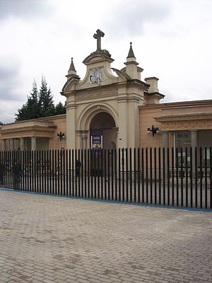
Central Cemetery of Bogotá
Distance: Approx. 1031 meters
Latitude and longitude: 4.61638889,-74.07527778
Central Cemetery of Bogotá (Spanish: Cementerio Central de Bogotá) is one of the main and most famous cemeteries in Colombia located in Bogotá. Houses several national heroes, poets and former Colombian presidents. It was opened in 1836 and was declared National Monument in 1984.

El Cartucho
Barrio in Distrital Capital Cundinamarca, Colombia
Distance: Approx. 1346 meters
Latitude and longitude: 4.59761,-74.08137639
El Cartucho or Calle del Cartucho was a street in the neighborhood of Santa Inés in Bogota which was destroyed and replaced by a park. At its time, it was one of the poorest and most dangerous areas in Colombia, known for rampant drug trafficking and inhabited by the poverty stricken. El Cartucho was widely considered to be a symbol of urban degradation.
Avianca Building
Office in Bogotá, Colombia
Distance: Approx. 1298 meters
Latitude and longitude: 4.6025,-74.0725
Avianca Building is a 161-meter-tall office skyscraper located at the intersection of 16th street and Seventh Avenue, next to Santander Park in the city of Bogotá, Colombia.

Hotel Tequendama
Hotel in Bogotá, Colombia
Distance: Approx. 1048 meters
Latitude and longitude: 4.61277778,-74.07277778
Hotel Tequendama & Centro de Convenciones (Convention Center) is an historic hotel in Bogotá, Colombia. It is located in the San Diego neighborhood of the town of Santa Fe at the intersection of Tenth Avenue and Twenty-Sixth Avenue. The hotel, designed by Holabird & Root, John Burgee, and the Colombian architectural firm Cuéllar Serrano Gómez, was constructed between 1950 and 1951.

Bogotá La Sabana railway station
Distance: Approx. 321 meters
Latitude and longitude: 4.60726,-74.08324
The Bogotá La Sabana railway station (in Spanish: Estación de la Sabana) is a neoclassical building in Bogotá (Colombia), home to the central station of the Bogotá Savannah Railway and the National Railways of Colombia (Ferrocarriles Nacionales de Colombia, FNC). Inaugurated on 20 July 1917, this construction replaced the old station built at the end of the 1880s. It is located on the locality of Los Mártires, near the downtown of the city.
Weather in this IP's area
scattered clouds
12 Celsius
12 Celsius
12 Celsius
12 Celsius
1019 hPa
100 %
1019 hPa
752 hPa
10000 meters
2.06 m/s
10 degree
40 %
05:52:48
18:12:37