Country:
 Belgium
Region:
City:
Latitude and Longitude:
Time Zone:
Postal Code:
IP information under different IP Channel
ip-api
Country
Region
City
ASN
Time Zone
ISP
Blacklist
Proxy
Latitude
Longitude
Postal
Route
IPinfo
Country
Region
City
ASN
Time Zone
ISP
Blacklist
Proxy
Latitude
Longitude
Postal
Route
MaxMind
Country
Region
City
ASN
Time Zone
ISP
Blacklist
Proxy
Latitude
Longitude
Postal
Route
Luminati
Country
 SE
SEASN
Time Zone
Europe/Stockholm
ISP
Arelion Sweden AB
Latitude
Longitude
Postal
db-ip
Country
Region
City
ASN
Time Zone
ISP
Blacklist
Proxy
Latitude
Longitude
Postal
Route
ipdata
Country
Region
City
ASN
Time Zone
ISP
Blacklist
Proxy
Latitude
Longitude
Postal
Route
Popular places and events near this IP address

De Brouckère metro station
Metro station in Brussels, Belgium
Distance: Approx. 245 meters
Latitude and longitude: 50.85083333,4.35222222
De Brouckère is a rapid transit station located beneath the Place de Brouckère/De Brouckèreplein in central Brussels, Belgium. It consists of both a metro station (serving lines 1 and 5) and a premetro (underground tram) station (serving lines 3 and 4 on the North–South Axis between Brussels-North railway station and Albert premetro station). The station opened on 17 December 1969, as a premetro station on the tram line between De Brouckère and Schuman, and it also became a heavy metro station in 1976, serving former lines 1A and 1B. Following the reorganisation of the Brussels Metro on 4 April 2009, it is served by lines 1 and 5, which cross Brussels from east to west.
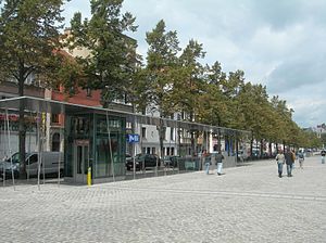
Sainte-Catherine metro station
Metro station in Brussels, Belgium
Distance: Approx. 215 meters
Latitude and longitude: 50.85222222,4.34777778
Sainte-Catherine (French) or Sint-Katelijne (Dutch) is a Brussels Metro station. It is located at the Place Sainte-Catherine/Sint-Katelijneplein, between the Quai aux Briques/Baksteenkaai and the Quai au Bois à Brûler/Brandhoutkaai, in the municipality of the City of Brussels, Belgium. It is also situated near Saint Catherine's Church, which gives the station its name.

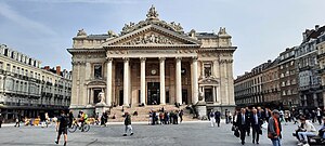
Brussels Stock Exchange
Stock exchange in Brussels, Belgium
Distance: Approx. 281 meters
Latitude and longitude: 50.84805556,4.35027778
The Brussels Stock Exchange (French: Bourse de Bruxelles; Dutch: Beurs van Brussel), abbreviated to BSE, was founded in Brussels, Belgium, by decree of Napoleon in 1801. In 2002, the BSE merged with the Amsterdam, Lisbon and Paris stock exchanges into Euronext, renaming the BSE Euronext Brussels. The most well known stock market index on the BSE is the BEL20.

Manstein Plan
War plan of the German Army during the Battle of France in 1940
Distance: Approx. 95 meters
Latitude and longitude: 50.85,4.35
The Manstein Plan or Case Yellow (German: Fall Gelb; also known after the war as Unternehmen Sichelschnitt a transliteration of the English Operation Sickle Cut), was the war plan of the German armed forces (Wehrmacht) for the Battle of France in 1940. The original invasion plan was an awkward compromise devised by General Franz Halder, the chief of staff of Oberkommando des Heeres (OKH, Army High Command) that satisfied no one. Documents with details of the plan fell into Belgian hands during the Mechelen incident on 10 January 1940 and the plan was revised several times, each giving more emphasis to an attack by Army Group A through the Ardennes, which progressively reduced the offensive by Army Group B through the Low Countries to a diversion.
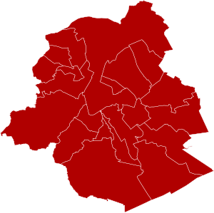
Arrondissement of Brussels-Capital
Administrative Arrondissement in Brussels Capital Region, Belgium
Distance: Approx. 95 meters
Latitude and longitude: 50.85,4.35
The Arrondissement of Brussels-Capital (Dutch: Arrondissement Brussel-Hoofdstad; French: Arrondissement de Bruxelles-Capitale; German: Verwaltungsbezirk Brüssel-Hauptstadt) is the only administrative arrondissement in the Brussels Capital Region in Belgium. Because it is the only administrative arrondissement in the Brussels Region, its territory coincides with that of the latter. The arrondissement was created in 1963 upon the splitting of the arrondissement of Brussels into the capital one and the surrounding arrondissement of Halle-Vilvoorde.
Saint-Géry Island
Former island in Brussels, Belgium
Distance: Approx. 270 meters
Latitude and longitude: 50.8481,4.3476
Saint-Géry Island (French: île Saint-Géry) or Sint-Goriks Island (Dutch: ) was the largest island in the river Senne in Brussels, Belgium. It was named after Saint Gaugericus of Cambrai, who according to legend, built a chapel there around 580. It ceased to exist as an island when the Senne was covered over in the late 19th century, and a former covered market, the Halles Saint-Géry/Sint-Gorikshallen, was built in its centre.

Bourse - Grand-Place premetro station
Metro station in Brussels, Belgium
Distance: Approx. 259 meters
Latitude and longitude: 50.8481,4.34936
Bourse - Grand-Place (French) or Beurs - Grote Markt (Dutch) is a premetro (underground tram) station in central Brussels, Belgium, located under the Boulevard Anspach/Anspachlaan, next to the Place de la Bourse/Beursplein and the former Brussels Stock Exchange, after which it is named. It is also located metres from the Grand-Place/Grote Markt (Brussels' main square). The station in part of the North–South Axis, a tram tunnel crossing the city centre between Brussels-North railway station and Albert premetro station.

Saint John the Baptist at the Béguinage
Church in Brussels, Belgium
Distance: Approx. 282 meters
Latitude and longitude: 50.85270278,4.35046667
The Church of St. John the Baptist at the Béguinage (French: Église Saint-Jean-Baptiste au Béguinage; Dutch: Sint-Jan-Baptist ten Begijnhofkerk) is a Roman Catholic parish church in central Brussels, Belgium. It is dedicated to Saint John the Baptist.

Brussels massacre
1370 killing of Jews in Brussels, present-day Belgium
Distance: Approx. 95 meters
Latitude and longitude: 50.85,4.35
The Brussels massacre was an anti-Semitic episode in Brussels (then within the Duchy of Brabant) in 1370 in connection with an alleged host desecration at the Brussels synagogue. A number of Jews, variously given as six or about twenty, were executed or otherwise killed, while the rest of the small community was banished. The event occurred on May 22.
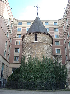
Black Tower (Brussels)
Medieval tower in Brussels, Belgium
Distance: Approx. 81 meters
Latitude and longitude: 50.85083333,4.34972222
The Black Tower (French: Tour Noire; Dutch: Zwarte Toren) is a medieval tower in central Brussels, Belgium. It is one of the best preserved remains of the first fortifications of Brussels, built at the start of the 13th century. It is notable for being a single medieval tower surrounded by modern-day buildings.
Place de la Bourse, Brussels
Square in Brussels, Belgium
Distance: Approx. 239 meters
Latitude and longitude: 50.84833333,4.34972222
The Place de la Bourse (French) or Beursplein (Dutch), meaning "Stock Exchange Square", is a major square in central Brussels, Belgium. It was created following the covering of the river Senne (1867–1871). The former Brussels Stock Exchange building, of which it takes its name, is located on this square.

Saint Catherine's Church, Brussels
Church in Brussels, Belgium
Distance: Approx. 50 meters
Latitude and longitude: 50.85083333,4.34861111
Saint Catherine's Church (French: Église Sainte-Catherine; Dutch: Sint-Katelijnekerk) is a Roman Catholic parish church in Brussels, Belgium. It is dedicated to Saint Catherine. The current church was designed by the architect Joseph Poelaert and built between 1854 and 1874 on the site of a basin of the former Port of Brussels, replacing an older church dating back to the 15th century.
Weather in this IP's area
clear sky
24 Celsius
24 Celsius
23 Celsius
25 Celsius
1025 hPa
52 %
1025 hPa
1021 hPa
10000 meters
2.57 m/s
50 degree
06:03:26
21:34:32