Country:
 USA
USARegion:
City:
Latitude and Longitude:
Time Zone:
Postal Code:
IP information under different IP Channel
ip-api
Country
Region
City
ASN
Time Zone
ISP
Blacklist
Proxy
Latitude
Longitude
Postal
Route
IPinfo
Country
Region
City
ASN
Time Zone
ISP
Blacklist
Proxy
Latitude
Longitude
Postal
Route
MaxMind
Country
Region
City
ASN
Time Zone
ISP
Blacklist
Proxy
Latitude
Longitude
Postal
Route
Luminati
Country
USRegion
fl
City
gainesville
ASN
Time Zone
America/New_York
ISP
UNITAS
Latitude
Longitude
Postal
db-ip
Country
Region
City
ASN
Time Zone
ISP
Blacklist
Proxy
Latitude
Longitude
Postal
Route
ipdata
Country
Region
City
ASN
Time Zone
ISP
Blacklist
Proxy
Latitude
Longitude
Postal
Route
Popular places and events near this IP address
Bedford, New Hampshire
Town in New Hampshire, United States
Distance: Approx. 379 meters
Latitude and longitude: 42.94638889,-71.51583333
Bedford is a town in Hillsborough County, New Hampshire, United States. At the 2020 census, the population was 23,322, reflecting a growth of 10% from 2010. Bedford is a suburb of Manchester, New Hampshire's largest city.

Saint Anselm College
Benedictine college in Goffstown, New Hampshire, U.S.
Distance: Approx. 4664 meters
Latitude and longitude: 42.985,-71.50638889
Saint Anselm College is a private Benedictine liberal arts college in Goffstown, New Hampshire. Founded in 1889, it is the third-oldest Catholic college in New England. Named after Saint Anselm of Canterbury, the college continues to have a fully functioning and independent Benedictine abbey attached to it, Saint Anselm Abbey.

Sebbins Pond
Distance: Approx. 3759 meters
Latitude and longitude: 42.92805556,-71.47888889
Sebbins Pond is an approximately 20-acre (81,000 m2) body of water in Bedford, New Hampshire. It is located in the eastern part of the town, between Back River Road and the Everett Turnpike. It is named for a man with the last name of Sebbins, who in 1735 set up shop at a site near the pond to make shingles, which he then dragged down to the nearby Merrimack River to ship – two years before the first permanent settlement in Bedford in 1737.

Bedford High School (New Hampshire)
Public high school in Bedford, New Hampshire, United States
Distance: Approx. 954 meters
Latitude and longitude: 42.936,-71.516
Bedford High School is a public high school in the town of Bedford, New Hampshire, United States. The high school adjoins the town's Ross A. Lurgio Middle School (7th and 8th grades). The combined schools are situated on a 40-acre (160,000 m2) campus at 47 Nashua Road.

Mount Washington College
For-profit college in Manchester, New Hampshire (1900–2016)
Distance: Approx. 5128 meters
Latitude and longitude: 42.97222222,-71.46944444
Mount Washington College was a for-profit college in Manchster, New Hampshire, United States. It opened in 1900 and was known as Hesser College until 2013. It was owned by Kaplan, Inc., and offered associate and bachelor's degrees focused in business and information technology, and claimed a flexible class scheduling system tailored to a diverse group of students.
St. Joseph Cemetery (Manchester, New Hampshire)
Cemetery in New Hampshire, United States
Distance: Approx. 4157 meters
Latitude and longitude: 42.97527778,-71.49111111
Saint Joseph Cemetery is a Corporal Work of Mercy of the Roman Catholic Bishop of Manchester, New Hampshire. It is administered in his name by the pastor and people of the Cathedral of St. Joseph, Manchester.

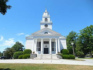
Bedford Presbyterian Church
Historic church in New Hampshire, United States
Distance: Approx. 102 meters
Latitude and longitude: 42.945,-71.52
The Bedford Presbyterian Church is a historic Presbyterian church building at 4 Church Road in Bedford, New Hampshire. The white clapboard structure was built in 1832 for a congregation organized in 1749 and was for many years the town's only church. The building was listed on the National Register of Historic Places in 2007.

Saint Anselm Abbey (New Hampshire)
American Benedictine monastery in New Hampshire
Distance: Approx. 4774 meters
Latitude and longitude: 42.98638889,-71.50888889
Saint Anselm Abbey, located in Goffstown, New Hampshire, United States, is a Benedictine abbey composed of men living under the Rule of Saint Benedict within the Catholic Church. The abbey was founded in 1889 under the patronage of Saint Anselm of Canterbury, a Benedictine monk of Bec and former archbishop of Canterbury in England. The monks are involved in the operation of Saint Anselm College.
New Hampshire Institute of Politics
Distance: Approx. 5022 meters
Latitude and longitude: 42.98666667,-71.49861111
The New Hampshire Institute of Politics (NHIOP) is an academic institute at Saint Anselm College in Goffstown, New Hampshire. Founded in 2001, the institute has hosted hundreds of potential candidates for the U.S. presidency.

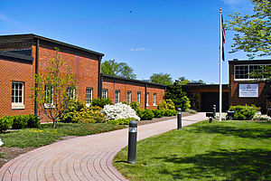
Bedford Town Hall
United States historic place
Distance: Approx. 379 meters
Latitude and longitude: 42.94638889,-71.51583333
The Bedford Town Hall is located at 70 Bedford Center Road in Bedford, New Hampshire. Built in 1910, it is a prominent early work of Chase R. Whitcher, a noted architect of northern New England in the early 20th century. The building is the third town hall to stand on this site, and was listed on the National Register of Historic Places in 1984.

Varney School
United States historic place
Distance: Approx. 5213 meters
Latitude and longitude: 42.98027778,-71.47861111
The Varney School is a historic school building at 84 Varney Street in Manchester, New Hampshire. Built in 1890 and enlarged in 1914-15, it is a well-preserved example of a Late Victorian school building, and an emblem of the growth in that time of the city's west side. The building was listed on the National Register of Historic Places in 1982.
WBNH-LP
Radio station in New Hampshire, United States
Distance: Approx. 454 meters
Latitude and longitude: 42.94675,-71.51505556
WBNH-LP is an alternative rock formatted broadcast radio station licensed to Bedford, New Hampshire, serving Manchester, and its immediate southern and western suburbs in New Hampshire. WBNH-LP is owned and operated by the Town of Bedford, New Hampshire. The station was assigned the WBNH-LP call sign on November 6, 2014, and was licensed on February 8, 2016.
Weather in this IP's area
overcast clouds
22 Celsius
22 Celsius
21 Celsius
23 Celsius
1018 hPa
67 %
1018 hPa
1007 hPa
10000 meters
0.84 m/s
0.95 m/s
80 degree
100 %
05:33:20
20:11:34