Country:
 France
Region:
City:
Latitude and Longitude:
Time Zone:
Postal Code:
IP information under different IP Channel
ip-api
Country
Region
City
ASN
Time Zone
ISP
Blacklist
Proxy
Latitude
Longitude
Postal
Route
IPinfo
Country
Region
City
ASN
Time Zone
ISP
Blacklist
Proxy
Latitude
Longitude
Postal
Route
MaxMind
Country
Region
City
ASN
Time Zone
ISP
Blacklist
Proxy
Latitude
Longitude
Postal
Route
Luminati
Country
 CH
CHASN
Time Zone
Europe/Zurich
ISP
VTX Services SA
Latitude
Longitude
Postal
db-ip
Country
Region
City
ASN
Time Zone
ISP
Blacklist
Proxy
Latitude
Longitude
Postal
Route
ipdata
Country
Region
City
ASN
Time Zone
ISP
Blacklist
Proxy
Latitude
Longitude
Postal
Route
Popular places and events near this IP address
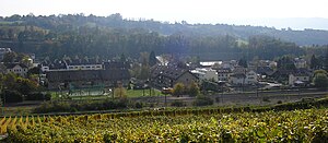
Dardagny
Municipality in Geneva, Switzerland
Distance: Approx. 5045 meters
Latitude and longitude: 46.18333333,6
Dardagny (French pronunciation: [daʁdaɲi]) is a municipality of the Canton of Geneva, Switzerland. In 1978, Dardagny received the Wakker Prize for the development and preservation of its architectural heritage.

Péron, Ain
Commune in Auvergne-Rhône-Alpes, France
Distance: Approx. 3163 meters
Latitude and longitude: 46.19,5.9264
Péron (French pronunciation: [peʁɔ̃]) is a commune in the Ain department in eastern France.

Challex
Commune in Auvergne-Rhône-Alpes, France
Distance: Approx. 4022 meters
Latitude and longitude: 46.1814,5.9758
Challex is a commune in the Ain department in eastern France.

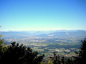
Le Reculet
Distance: Approx. 5111 meters
Latitude and longitude: 46.25666667,5.93
Le Reculet is the second-highest peak in the Jura Mountains, with an elevation of 1718 metres. It is located in the Ain department of France. It is a few kilometres south of the Crêt de la Neige on the territory of the town of Thoiry.

Saint-Jean-de-Gonville
Commune in Auvergne-Rhône-Alpes, France
Distance: Approx. 403 meters
Latitude and longitude: 46.2166,5.95
Saint-Jean-de-Gonville (French pronunciation: [sɛ̃ ʒɑ̃ də ɡɔ̃vil]; Arpitan: Sant-Jian-de-Govèlyes) is a commune in the Ain department in eastern France.

Sergy, Ain
Commune in Auvergne-Rhône-Alpes, France
Distance: Approx. 5727 meters
Latitude and longitude: 46.252,5.999
Sergy (French pronunciation: [sɛʁʒi]; Arpitan: Sèrgi) is a commune in the Ain department in eastern France.
Thoiry, Ain
Commune in Auvergne-Rhône-Alpes, France
Distance: Approx. 3554 meters
Latitude and longitude: 46.2372,5.9806
Thoiry (French pronunciation: [twaʁi]) is a commune in the Ain department in eastern France. The little village was the scene of the September 1926 meeting between Aristide Briand of France and Gustav Stresemann of Germany. During the meeting the two discussed proposals for finally settling the various claims from the First World War, and their common interest in the then-fashionable paneuropean ideas.

Dardagny Castle
Swiss Castle
Distance: Approx. 4037 meters
Latitude and longitude: 46.19416667,5.99527778
Dardagny Castle is a castle in the municipality of Dardagny in the Canton of Geneva in Switzerland. It is a Swiss heritage site of national significance.
La Plaine, Geneva
Distance: Approx. 5530 meters
Latitude and longitude: 46.17777778,6.00111111
La Plaine is a village in Switzerland forming part of the commune of Dardagny in the canton of Geneva. On the right bank of the Rhône, it is the site of a perfume factory belonging to the Firmenich group.
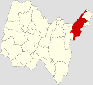
Canton of Thoiry
Canton of France
Distance: Approx. 2957 meters
Latitude and longitude: 46.23,5.98
The canton of Thoiry is an administrative division of the Ain department, in eastern France. It was created at the French canton reorganisation which came into effect in March 2015. Its seat is in Thoiry.

Russin railway station
Distance: Approx. 5899 meters
Latitude and longitude: 46.18805556,6.01805556
Russin railway station (French: Gare de Russin) is a railway station in the municipality of Russin, in the Swiss canton of Geneva. It is an intermediate stop on the standard gauge Lyon–Geneva line of Swiss Federal Railways.

La Plaine railway station
Distance: Approx. 5399 meters
Latitude and longitude: 46.1786654,5.99999275
La Plaine railway station (French: Gare de La Plaine) is a railway station in the municipality of Dardagny, in the Swiss canton of Geneva. It is an intermediate stop on the standard gauge Lyon–Geneva line of Swiss Federal Railways.
Weather in this IP's area
clear sky
18 Celsius
18 Celsius
18 Celsius
20 Celsius
1021 hPa
84 %
1021 hPa
962 hPa
10000 meters
0.51 m/s
340 degree
06:14:39
21:10:27