Country:
 Switzerland
Region:
City:
Latitude and Longitude:
Time Zone:
Postal Code:
IP information under different IP Channel
ip-api
Country
Region
City
ASN
Time Zone
ISP
Blacklist
Proxy
Latitude
Longitude
Postal
Route
IPinfo
Country
Region
City
ASN
Time Zone
ISP
Blacklist
Proxy
Latitude
Longitude
Postal
Route
MaxMind
Country
Region
City
ASN
Time Zone
ISP
Blacklist
Proxy
Latitude
Longitude
Postal
Route
Luminati
Country
CHASN
Time Zone
Europe/Zurich
ISP
VTX Services SA
Latitude
Longitude
Postal
db-ip
Country
Region
City
ASN
Time Zone
ISP
Blacklist
Proxy
Latitude
Longitude
Postal
Route
ipdata
Country
Region
City
ASN
Time Zone
ISP
Blacklist
Proxy
Latitude
Longitude
Postal
Route
Popular places and events near this IP address
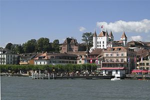
Nyon
Place in Vaud, Switzerland
Distance: Approx. 481 meters
Latitude and longitude: 46.38333333,6.23333333
Nyon (French pronunciation: [njɔ̃] ; historically German: Neuis or Neuss and Italian: Nione, [ˈnjoːne]) is a municipality in Nyon District in the canton of Vaud in Switzerland. It is located some 25 kilometers north east of Geneva's city centre, and since the 1970s it has become part of the Geneva metropolitan area. It lies on the shores of Lake Geneva and is the seat of Nyon District.

Prangins
Municipality in Vaud, Switzerland
Distance: Approx. 2034 meters
Latitude and longitude: 46.4,6.25
Prangins (French pronunciation: [pʁɑ̃ʒɛ̃]) is a municipality in the district of Nyon in the canton of Vaud in Switzerland. It is located on Lake Geneva.

Eysins
Municipality in Vaud, Switzerland
Distance: Approx. 3041 meters
Latitude and longitude: 46.38333333,6.2
Eysins is a municipality in the district of Nyon in the canton of Vaud in Switzerland.
Signy-Avenex
Municipality in Vaud, Switzerland
Distance: Approx. 3041 meters
Latitude and longitude: 46.38333333,6.2
Signy-Avenex (French pronunciation: [siɲi avnɛ] ) is a municipality in the district of Nyon in the canton of Vaud in Switzerland.

HBG (time signal)
Time signal radio station in Switzerland
Distance: Approx. 2977 meters
Latitude and longitude: 46.408356,6.252769
HBG was a low frequency time signal transmitter for the Swiss time reference system. It transmitted on 75 kHz with 20 kW power, and was located in Prangins, Switzerland. Due to the cost of urgently needed renovation for the ageing antennas, and the ease with which all existing users could switch to the DCF77 time signal, the Swiss Federal Government decided to shut down HBG at the end of 2011.

Colovray Sports Centre
Stadium in Vaud, Switzerland
Distance: Approx. 1730 meters
Latitude and longitude: 46.370711,6.226201
Centre Sportif de Colovray Nyon is where FC Stade Nyonnais play their home football and rugby games. The site is opposite the UEFA headquarters. The centre has six pitches for different things and hosts a variety of activities, football, rugby and athletics.
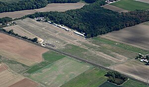
La Côte Airfield
Private airfield in Switzerland
Distance: Approx. 2945 meters
Latitude and longitude: 46.40638889,6.25805556
The La Côte Airfield (ICAO code LSGP) is a private airfield in Prangins, Switzerland. It hosted a fly-in in 2009, 2011, 2013, on August 15, 2015 and in 2019.
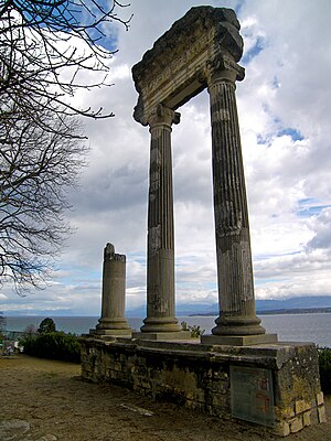
Noviodunum (Switzerland)
Distance: Approx. 274 meters
Latitude and longitude: 46.381,6.238
Noviodunum or Colonia Iulia Equestris was a Roman era settlement in what is now Nyon in the Canton of Vaud in Switzerland. Noviodunum is a name of Celtic origin, meaning "new fort": It comes from nowyo, Celtic for "new", and dun, the Celtic for "hillfort" or "fortified settlement", cognate of English town. It was the urban center of the larger Colonia.

Nyon Castle
Castle in Nyon, Switzerland
Distance: Approx. 138 meters
Latitude and longitude: 46.38218,6.24063
Nyon Castle is a castle in the municipality of Nyon of the Canton of Vaud in Switzerland. It is a Swiss heritage site of national significance.

Duillier Castle
Castle in Duillier, Switzerland
Distance: Approx. 2662 meters
Latitude and longitude: 46.406822,6.234244
Duillier Castle is a castle in the municipality of Duillier of the Canton of Vaud in Switzerland. It is a Swiss heritage site of national significance.
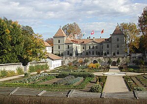
Prangins Castle
Castle in Prangins, Switzerland
Distance: Approx. 1546 meters
Latitude and longitude: 46.39416,6.25196
Prangins Castle is a castle in the municipality of Prangins of the Canton of Vaud in Switzerland. It is a Swiss heritage site of national significance. It is home to one part of the Swiss National Museum.

Nyon railway station
Swiss railway station
Distance: Approx. 306 meters
Latitude and longitude: 46.38438889,6.236
Nyon railway station (French: Gare de Nyon) is a railway station in the municipality of Nyon, in the Swiss canton of Vaud. It is an intermediate stop on the standard gauge Lausanne–Geneva line of Swiss Federal Railways and the southern terminus of the 1,000 mm (3 ft 3+3⁄8 in) gauge Nyon–St-Cergue–Morez line of the Chemin de fer Nyon–St-Cergue–Morez.
Weather in this IP's area
clear sky
18 Celsius
18 Celsius
18 Celsius
19 Celsius
1022 hPa
87 %
1022 hPa
977 hPa
10000 meters
0.51 m/s
06:12:58
21:09:50