Country:
 Switzerland
Region:
City:
Latitude and Longitude:
Time Zone:
Postal Code:
IP information under different IP Channel
ip-api
Country
Region
City
ASN
Time Zone
ISP
Blacklist
Proxy
Latitude
Longitude
Postal
Route
IPinfo
Country
Region
City
ASN
Time Zone
ISP
Blacklist
Proxy
Latitude
Longitude
Postal
Route
MaxMind
Country
Region
City
ASN
Time Zone
ISP
Blacklist
Proxy
Latitude
Longitude
Postal
Route
Luminati
Country
CHASN
Time Zone
Europe/Zurich
ISP
VTX Services SA
Latitude
Longitude
Postal
db-ip
Country
Region
City
ASN
Time Zone
ISP
Blacklist
Proxy
Latitude
Longitude
Postal
Route
ipdata
Country
Region
City
ASN
Time Zone
ISP
Blacklist
Proxy
Latitude
Longitude
Postal
Route
Popular places and events near this IP address
Colombier, Neuchâtel
Former municipality in Neuchâtel, Switzerland
Distance: Approx. 2892 meters
Latitude and longitude: 46.96666667,6.86666667
Colombier (French pronunciation: [kɔlɔ̃bje] ) is a former municipality in the Boudry District in the canton of Neuchâtel in Switzerland. The municipalities of Auvernier, Bôle and Colombier merged on 1 January 2013 into the new municipality of Milvignes.
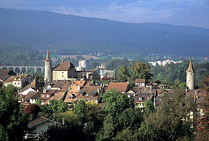
Boudry
Municipality in Neuchâtel, Switzerland
Distance: Approx. 324 meters
Latitude and longitude: 46.95,6.83333333
Boudry is a municipality in the canton of Neuchâtel in Switzerland.

Cortaillod
Municipality in Neuchâtel, Switzerland
Distance: Approx. 942 meters
Latitude and longitude: 46.95,6.85
Cortaillod is a municipality in the canton of Neuchâtel in Switzerland. The Neolithic Cortaillod culture was named after Cortaillod, where four Neolithic villages have been discovered.
Bevaix
Former municipality in Neuchâtel, Switzerland
Distance: Approx. 2436 meters
Latitude and longitude: 46.93333333,6.81666667
Bevaix is a former municipality in the district of Boudry in the canton of Neuchâtel in Switzerland. On 1 January 2018 the former municipalities of Bevaix, Saint-Aubin-Sauges, Gorgier, Vaumarcus, Montalchez and Fresens merged into the new municipality of La Grande-Béroche.
Bôle
Former municipality in Neuchâtel, Switzerland
Distance: Approx. 2091 meters
Latitude and longitude: 46.96666667,6.85
Bôle is a former municipality in the district of Boudry in the canton of Neuchâtel in Switzerland. The municipalities of Auvernier, Bôle and Colombier merged on 1 January 2013 into the new municipality of Milvignes.
Boudry District
District in Switzerland
Distance: Approx. 324 meters
Latitude and longitude: 46.95,6.83333333
Boudry District was one of the six districts of the canton of Neuchâtel, Switzerland, until the district level was eliminated on 1 January 2018. It had a population of 40,701. The district capital was the town of Boudry.
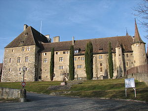
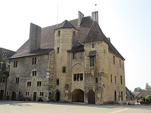
Colombier Castle
Distance: Approx. 2645 meters
Latitude and longitude: 46.96611111,6.86305556
Colombier Castle is a castle in the former municipality of Colombier (now part of Milvignes) of the Canton of Neuchâtel in Switzerland. It is a Swiss heritage site of national significance.
Neuchâtel Airport
Airport in Neuchâtel, Switzerland
Distance: Approx. 2243 meters
Latitude and longitude: 46.957556,6.864907
Neuchâtel Airport is an airport in Neuchâtel, Switzerland.

Colombier railway station
Distance: Approx. 2152 meters
Latitude and longitude: 46.96763611,6.84888389
Colombier railway station (French: Gare de Colombier) is a railway station in the municipality of Milvignes, in the Swiss canton of Neuchâtel. It is an intermediate stop on the standard gauge Jura Foot line of Swiss Federal Railways.

Boudry railway station
Distance: Approx. 1080 meters
Latitude and longitude: 46.959446,6.83505439
Boudry railway station (French: Gare de Boudry) is a railway station in the municipality of Boudry, in the Swiss canton of Neuchâtel. It is an intermediate stop on the standard gauge Jura Foot line of Swiss Federal Railways.
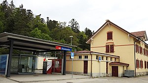
Chambrelien railway station
Distance: Approx. 2716 meters
Latitude and longitude: 46.96710611,6.81226389
Chambrelien railway station (French: Gare de Chambrelien) is a railway station in the municipality of Rochefort, in the Swiss canton of Neuchâtel. It is a reversing station on the standard gauge Neuchâtel–Le Locle-Col-des-Roches line of Swiss Federal Railways.

Bôle railway station
Distance: Approx. 2174 meters
Latitude and longitude: 46.96942306,6.83837389
Bôle railway station (French: Gare de Bôle) is a railway station in the municipality of Milvignes, in the Swiss canton of Neuchâtel. It is an intermediate stop on the standard gauge Neuchâtel–Pontarlier line of Swiss Federal Railways.
Weather in this IP's area
clear sky
18 Celsius
18 Celsius
17 Celsius
20 Celsius
1022 hPa
91 %
1022 hPa
970 hPa
10000 meters
06:08:45
21:09:16