Country:
 France
Region:
City:
Latitude and Longitude:
Time Zone:
Postal Code:
IP information under different IP Channel
ip-api
Country
Region
City
ASN
Time Zone
ISP
Blacklist
Proxy
Latitude
Longitude
Postal
Route
IPinfo
Country
Region
City
ASN
Time Zone
ISP
Blacklist
Proxy
Latitude
Longitude
Postal
Route
MaxMind
Country
Region
City
ASN
Time Zone
ISP
Blacklist
Proxy
Latitude
Longitude
Postal
Route
Luminati
Country
 CH
CHASN
Time Zone
Europe/Zurich
ISP
VTX Services SA
Latitude
Longitude
Postal
db-ip
Country
Region
City
ASN
Time Zone
ISP
Blacklist
Proxy
Latitude
Longitude
Postal
Route
ipdata
Country
Region
City
ASN
Time Zone
ISP
Blacklist
Proxy
Latitude
Longitude
Postal
Route
Popular places and events near this IP address

Chaveyriat
Commune in Auvergne-Rhône-Alpes, France
Distance: Approx. 5920 meters
Latitude and longitude: 46.1833,5.0667
Chaveyriat (French pronunciation: [ʃaveʁja]) is a commune in the Ain department in eastern France. It sits north of the D396 road, and is located 7 km north east of Neuville-les-Dames and 13 km west of Bourg-en-Bresse. The romanesque parish church is dedicated to St John the Baptist.
Condeissiat
Commune in Auvergne-Rhône-Alpes, France
Distance: Approx. 6215 meters
Latitude and longitude: 46.1667,5.0833
Condeissiat (French pronunciation: [kɔ̃dɛsja]; Arpitan: Condèssiê) is a commune in the Ain department in eastern France.
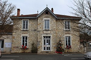
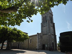
Buellas
Commune in Auvergne-Rhône-Alpes, France
Distance: Approx. 1239 meters
Latitude and longitude: 46.2,5.1333
Buellas (French pronunciation: [bɥɛlas] ; Arpitan: Bouèla) is a commune in the Ain department in eastern France.

Saint-André-sur-Vieux-Jonc
Commune in Auvergne-Rhône-Alpes, France
Distance: Approx. 6078 meters
Latitude and longitude: 46.1575,5.1472
Saint-André-sur-Vieux-Jonc is a commune in the Ain department in eastern France.

Montcet
Commune in Auvergne-Rhône-Alpes, France
Distance: Approx. 1492 meters
Latitude and longitude: 46.2133,5.1131
Montcet (French pronunciation: [mɔ̃sɛ]) is a commune in the Ain department in eastern France.

Montracol
Commune in Auvergne-Rhône-Alpes, France
Distance: Approx. 3317 meters
Latitude and longitude: 46.1833,5.1167
Montracol (French pronunciation: [mɔ̃ʁakɔl]) is a commune in the Ain department in eastern France.

Polliat
Commune in Auvergne-Rhône-Alpes, France
Distance: Approx. 4351 meters
Latitude and longitude: 46.25,5.1267
Polliat (French pronunciation: [pɔlja]) is a commune in the Ain department in eastern France.
Saint-Denis-lès-Bourg
Commune in Auvergne-Rhône-Alpes, France
Distance: Approx. 4555 meters
Latitude and longitude: 46.2025,5.19
Saint-Denis-lès-Bourg (French pronunciation: [sɛ̃ dəni lɛ buʁ] , literally Saint-Denis near Bourg) is a commune in the Ain department in eastern France.

Saint-Rémy, Ain
Commune in Auvergne-Rhône-Alpes, France
Distance: Approx. 3694 meters
Latitude and longitude: 46.19,5.1692
Saint-Rémy (French pronunciation: [sɛ̃ ʁemi] ) is a commune in the Ain department in eastern France.

Vandeins
Commune in Auvergne-Rhône-Alpes, France
Distance: Approx. 4100 meters
Latitude and longitude: 46.2183,5.08
Vandeins (French pronunciation: [vɑ̃dɛ̃]; Arpitan: Vandens) is a commune in the Ain department in eastern France.
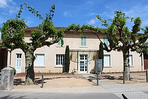
Parc botanique de la Teyssonnière
Botanical garden in Rhône-Alpes, France
Distance: Approx. 1157 meters
Latitude and longitude: 46.2036,5.1426
The Parc botanique de la Teyssonnière (15 hectares) is a botanical garden and park located on the Chemin de La Teyssonnière, Buellas, Ain, Rhône-Alpes, France. It is open daily in May; an admission fee is charged. The garden was originally created as a park surrounding the mansion of engineer and mayor Charles-de-Nestor Agricol Lateyssonnière (1777-1845), and revived from 1957 onwards by radiologist Dr.
Arboretum des Grands Murcins
Distance: Approx. 1448 meters
Latitude and longitude: 46.2,5.142
The Arboretum des Grands Murcins (3 hectares) is a private arboretum located near Arcon, Loire, Auvergne-Rhône-Alpes, France. It is open daily without charge. The arboretum was created in 1936-1937 by the Friends of Trees and the Savings Bank of Roanne, on an experimental plot of 2 hectares at an altitude of 760 meters.
Weather in this IP's area
few clouds
17 Celsius
17 Celsius
17 Celsius
19 Celsius
1020 hPa
92 %
1020 hPa
994 hPa
10000 meters
0.76 m/s
1.2 m/s
354 degree
22 %
06:17:56
21:13:43