Country:
 Switzerland
Region:
City:
Latitude and Longitude:
Time Zone:
Postal Code:
IP information under different IP Channel
ip-api
Country
Region
City
ASN
Time Zone
ISP
Blacklist
Proxy
Latitude
Longitude
Postal
Route
IPinfo
Country
Region
City
ASN
Time Zone
ISP
Blacklist
Proxy
Latitude
Longitude
Postal
Route
MaxMind
Country
Region
City
ASN
Time Zone
ISP
Blacklist
Proxy
Latitude
Longitude
Postal
Route
Luminati
Country
CHASN
Time Zone
Europe/Zurich
ISP
VTX Services SA
Latitude
Longitude
Postal
db-ip
Country
Region
City
ASN
Time Zone
ISP
Blacklist
Proxy
Latitude
Longitude
Postal
Route
ipdata
Country
Region
City
ASN
Time Zone
ISP
Blacklist
Proxy
Latitude
Longitude
Postal
Route
Popular places and events near this IP address
TASIS Switzerland
American international school in Montagnola, Lugano, Canton of Ticino, Switzerland
Distance: Approx. 151 meters
Latitude and longitude: 45.9829,8.9168
TASIS or TASIS Switzerland, formally known as The American School In Switzerland, is a private American international boarding and day school in Switzerland. TASIS ranked number 67 in IB test scores among European private schools. Located in Montagnola, Collina D'Oro near Lugano, in the Canton of Ticino, the school enrolls approximately 700 pupils from around the world.

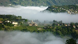
Montagnola
Swiss village in Ticino
Distance: Approx. 199 meters
Latitude and longitude: 45.98333333,8.91666667
Montagnola (Italian pronunciation: [montaɲˈɲola]) is a small Swiss village in Collina d'Oro municipality. Located in the Italian-speaking canton of Ticino, it is close to the border between Switzerland and Italy. It looks over Lake Lugano and the city of Lugano upon it.
Collina d'Oro
Municipality in Ticino, Switzerland
Distance: Approx. 199 meters
Latitude and longitude: 45.98333333,8.91666667
Collina d'Oro (English: Golden Hill) is a municipality in the district of Lugano in the canton of Ticino in Switzerland. It was formed from the 2004 union of the villages of Agra, Gentilino, and Montagnola. On 1 April 2012, it incorporated the formerly independent municipality of Carabietta.
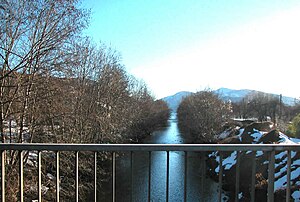
Vedeggio
River in Switzerland
Distance: Approx. 1671 meters
Latitude and longitude: 45.9949,8.9074
The Vedeggio is a river of the Swiss Canton Ticino which rises on the slopes of Monte Camoghè (2200m) between Bellinzona and Lugano, crosses the plain of Vedeggio (which takes its name from the river), and enters Lake Lugano at Agno. Its final section, from the outskirts of Agno until its emission into Lake Lugano has been cut into a straight channel for ease of civil planning in the town.

Lago di Muzzano
Distance: Approx. 1905 meters
Latitude and longitude: 45.99722222,8.92805556
Lago di Muzzano is a lake in Ticino, Switzerland. It is bordered by the municipalities of Sorengo, Muzzano and Collina d'Oro. Its surface area is 23 ha (57 acres).

Agra, Switzerland
Distance: Approx. 1675 meters
Latitude and longitude: 45.96666667,8.91666667
Agra is a village and former municipality in the canton of Ticino, Switzerland. In 2004 the municipality was merged with the other, neighboring municipalities Gentilino and Montagnola to form a new and larger municipality Collina d'Oro.

Gentilino
Village in Switzerland
Distance: Approx. 1668 meters
Latitude and longitude: 45.99222222,8.93305556
Gentilino is a village and former municipality in the canton of Ticino, Switzerland, close to Lake Lugano and the city of Lugano. The local Church of Sant'Abbondio (in Italian: Chiesa di Sant'Abbondio a Gentilino - not to be confused with the Swiss municipality of Sant'Abbondio above Lake Maggiore, or the Basilica of Sant'Abbondio in Lombardy, Italy) is noteworthy for dating from the eleventh century. The cemetery of Sant'Abbondio is the resting place of Hugo Ball, Bruno Walter, and Hermann Hesse.
Pambio Noranco
Quarter in Ticino, Switzerland
Distance: Approx. 1486 meters
Latitude and longitude: 45.98888889,8.93388889
Pambio Noranco is a quarter of the city of Lugano, Switzerland. Pambio Noranco was formerly a municipality of its own, having been incorporated into Lugano in 2004.
Pambio
Distance: Approx. 1443 meters
Latitude and longitude: 45.988,8.934
Pambio is a village and former municipality in the District of Lugano, in the canton of Ticino in southern Switzerland.
Noranco
Distance: Approx. 742 meters
Latitude and longitude: 45.984,8.9267
Noranco is a village and former municipality in the district of Lugano in the canton of Ticino, Switzerland. The village, formerly a municipality of its own, was merged with neighboring Pambio in 1904 to form the new municipality of Pambio-Noranco. In 2004, the municipality was similarly incorporated into the larger, neighboring municipality of Lugano and now forms a quarter of that city.
Agnuzzo
Distance: Approx. 1373 meters
Latitude and longitude: 45.99399167,8.91618056
Agnuzzo is a village in the municipality of Muzzano, Canton of Ticino, Switzerland. The village borders Lake Lugano between Agno and Montagnola on the northern end of the lake's western spur. The current population is around 730.

Cappella-Agnuzzo railway station
Railway station in Switzerland
Distance: Approx. 1390 meters
Latitude and longitude: 45.99327,8.92444806
Cappella-Agnuzzo railway station is a railway station in the municipality of Collina d'Oro in the Swiss canton of Ticino. The station is on the metre gauge Lugano–Ponte Tresa railway (FLP), between Lugano and Ponte Tresa. The station has a passing loop, with side platforms.
Weather in this IP's area
scattered clouds
22 Celsius
22 Celsius
20 Celsius
23 Celsius
1021 hPa
83 %
1021 hPa
970 hPa
10000 meters
0.51 m/s
40 %
06:03:30
20:57:52