Country:
 Switzerland
Region:
City:
Latitude and Longitude:
Time Zone:
Postal Code:
IP information under different IP Channel
ip-api
Country
Region
City
ASN
Time Zone
ISP
Blacklist
Proxy
Latitude
Longitude
Postal
Route
IPinfo
Country
Region
City
ASN
Time Zone
ISP
Blacklist
Proxy
Latitude
Longitude
Postal
Route
MaxMind
Country
Region
City
ASN
Time Zone
ISP
Blacklist
Proxy
Latitude
Longitude
Postal
Route
Luminati
Country
CHRegion
ge
City
grandlancy
ASN
Time Zone
Europe/Zurich
ISP
VTX Services SA
Latitude
Longitude
Postal
db-ip
Country
Region
City
ASN
Time Zone
ISP
Blacklist
Proxy
Latitude
Longitude
Postal
Route
ipdata
Country
Region
City
ASN
Time Zone
ISP
Blacklist
Proxy
Latitude
Longitude
Postal
Route
Popular places and events near this IP address
Arrissoules Tunnel
Distance: Approx. 2973 meters
Latitude and longitude: 46.796,6.781
Arissoules Tunnel (French: Tunnel d'Arrissoules) is a motorway tunnel in the Swiss cantons of Fribourg and Vaud, near the village of Arrissoules. The tunnel forms part of the A1 motorway from Geneva to St. Margrethen.

Arrissoules
Village in Vaud, Switzerland
Distance: Approx. 2845 meters
Latitude and longitude: 46.79833333,6.77972222
Arrissoules is a village in the district of Yverdon of the Canton of Vaud, Switzerland. The village was an independent municipality until it was incorporated into Rovray on January 1, 2005. The Arrissoules Tunnel of the A1 motorway is located near the village.

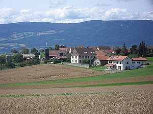
Chavannes-le-Chêne
Municipality in Vaud, Switzerland
Distance: Approx. 3640 meters
Latitude and longitude: 46.78333333,6.78333333
Chavannes-le-Chêne is a municipality in the district of Jura-Nord Vaudois of the canton of Vaud in Switzerland.

Chêne-Pâquier
Municipality in Vaud, Switzerland
Distance: Approx. 4173 meters
Latitude and longitude: 46.76666667,6.76666667
Chêne-Pâquier is a municipality in the district of Jura-Nord Vaudois of the canton of Vaud in Switzerland.

Molondin
Municipality in Vaud, Switzerland
Distance: Approx. 3787 meters
Latitude and longitude: 46.76666667,6.75
Molondin is a municipality in the district of Jura-Nord Vaudois of the canton of Vaud in Switzerland.
Rovray
Municipality in Vaud, Switzerland
Distance: Approx. 2638 meters
Latitude and longitude: 46.78333333,6.76666667
Rovray is a municipality in the district of Jura-Nord Vaudois in the canton of Vaud in Switzerland.

Villars-Epeney
Municipality in Vaud, Switzerland
Distance: Approx. 3750 meters
Latitude and longitude: 46.78333333,6.7
Villars-Epeney is a municipality in the district of Jura-Nord Vaudois of the canton of Vaud in Switzerland.

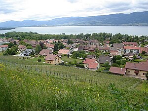
Yvonand
Municipality in Vaud, Switzerland
Distance: Approx. 572 meters
Latitude and longitude: 46.8,6.75
Yvonand is a municipality in the district of Jura-Nord Vaudois (former Yverdon) of the canton of Vaud in Switzerland. Located on the southwestern shore of Lake Neuchâtel the village has a population of almost 2,500 which may rise to 7,000 in summer, due to the popularity of the sandy beaches, which gently shelve into the lake.
Cheyres
Former municipality in Fribourg, Switzerland
Distance: Approx. 3605 meters
Latitude and longitude: 46.81666667,6.78333333
Cheyres (Arpitan: Chêres, locally Tsêre [ˈtsɛʁ(ə)] or Tsàrè) is a former municipality in the district of Broye in the canton of Fribourg in Switzerland. On 1 January 2017 the former municipalities of Cheyres and Châbles merged into the new municipality of Cheyres-Châbles.
Montborget
Village in the district of Broye in the canton of Fribourg, Switzerland
Distance: Approx. 3112 meters
Latitude and longitude: 46.80000556,6.78333889
Montborget (French: [mɔ̃bɔʁʒɛ], Franco-Provençal: [mɔ̃bɔʁˈdzɛ] ) is a village and former municipality in the district of Broye in the canton of Fribourg, Switzerland. It was first recorded in 1314 as Mauborget. The municipality had 98 inhabitants in 1811, which increased to 124 in 1850 and 137 in 1900.
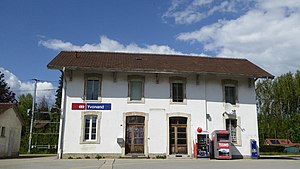
Yvonand railway station
Railway station in Yvonand, Switzerland
Distance: Approx. 325 meters
Latitude and longitude: 46.800875,6.74668694
Yvonand railway station (French: Gare d'Yvonand) is a railway station in the municipality of Yvonand, in the Swiss canton of Vaud. It is an intermediate stop on the standard gauge Fribourg–Yverdon line of Swiss Federal Railways.

Cheyres railway station
Railway station in Cheyres, Switzerland
Distance: Approx. 3823 meters
Latitude and longitude: 46.81694611,6.78639389
Cheyres railway station (French: Gare de Cheyres) is a railway station in the municipality of Cheyres, in the Swiss canton of Fribourg. It is an intermediate stop on the standard gauge Fribourg–Yverdon line of Swiss Federal Railways.
Weather in this IP's area
scattered clouds
18 Celsius
18 Celsius
17 Celsius
20 Celsius
1022 hPa
78 %
1022 hPa
972 hPa
10000 meters
2.17 m/s
3.32 m/s
46 degree
25 %
06:09:37
21:09:09