Country:
 Japan
JapanRegion:
City:
Latitude and Longitude:
Time Zone:
Postal Code:
IP information under different IP Channel
ip-api
Country
Region
City
ASN
Time Zone
ISP
Blacklist
Proxy
Latitude
Longitude
Postal
Route
IPinfo
Country
Region
City
ASN
Time Zone
ISP
Blacklist
Proxy
Latitude
Longitude
Postal
Route
MaxMind
Country
Region
City
ASN
Time Zone
ISP
Blacklist
Proxy
Latitude
Longitude
Postal
Route
Luminati
Country
JPRegion
24
City
oka
ASN
Time Zone
Asia/Tokyo
ISP
Matsusaka Cable-TV Station Inc.
Latitude
Longitude
Postal
db-ip
Country
Region
City
ASN
Time Zone
ISP
Blacklist
Proxy
Latitude
Longitude
Postal
Route
ipdata
Country
Region
City
ASN
Time Zone
ISP
Blacklist
Proxy
Latitude
Longitude
Postal
Route
Popular places and events near this IP address

Matsusaka
City in Kansai, Japan
Distance: Approx. 750 meters
Latitude and longitude: 34.57794444,136.52758333
Matsusaka (松阪市, Matsusaka-shi, Local dialect: Mattsaka or Massaka) is a city located in Mie Prefecture, Japan. As of 1 August 2021, the city had an estimated population of 157,235 in 66,018 households and a population density of 250 people per km². The total area of the city is 623.64 square kilometres (240.79 sq mi).

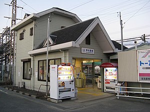
Matsusaka Station
Railway station in Matsusaka, Mie Prefecture, Japan
Distance: Approx. 720 meters
Latitude and longitude: 34.5768853,136.5355539
Matsusaka Station (松阪駅, Matsusaka-eki) is a union passenger railway station in the city of Matsusaka, Mie Prefecture, operated jointly by Central Japan Railway Company (JR Central) and Kintetsu.
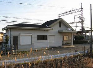
Higashi-Matsusaka Station
Railway station in Matsusaka, Mie Prefecture, Japan
Distance: Approx. 2284 meters
Latitude and longitude: 34.5655,136.546
Higashi-Matsusaka Station (東松阪駅, Higashi-Matsusaka-eki) is a passenger railway station located in the city of Matsusaka, Mie Prefecture, Japan, operated by the private railway operator Kintetsu Railway.
Ise-Nakahara Station
Railway station in Matsusaka, Mie Prefecture, Japan
Distance: Approx. 4828 meters
Latitude and longitude: 34.6149,136.4973
Ise-Nakahara Station (伊勢中原駅, Ise-Nakahara-eki) is a passenger railway station located in the city of Matsusaka, Mie Prefecture, Japan, operated by the private railway operator Kintetsu Railway.

Matsugasaki Station (Mie)
Railway station in Matsusaka, Mie Prefecture, Japan
Distance: Approx. 1990 meters
Latitude and longitude: 34.59638889,136.51861111
Matsugasaki Station (松ヶ崎駅, Matsugasaki-eki) is a passenger railway station located in the city of Matsusaka, Mie Prefecture, Japan, operated by the private railway operator Kintetsu Railway.
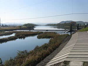
Kushida River
River in Japan
Distance: Approx. 4320 meters
Latitude and longitude: 34.605334,136.571556
The Kushida River (櫛田川, Kushida-gawa) is a major river that flows through central Mie Prefecture on the island of Honshū, Japan. It is officially classified as a Class 1 river by the Japanese government, one of four Class 1 rivers that flow solely through Mie. The majority of river's course is through the city of Matsusaka.

Rokken Station (Mie)
Railway station in Matsusaka, Mie Prefecture, Japan
Distance: Approx. 4495 meters
Latitude and longitude: 34.6175,136.5075
Rokken Station (六軒駅, Rokken-eki) is a railway station is a passenger railway station in located in the city of Matsusaka, Mie Prefecture, Japan, operated by Central Japan Railway Company (JR Tōkai).

Tokuwa Station
Railway station in Matsusaka, Mie Prefecture, Japan
Distance: Approx. 3740 meters
Latitude and longitude: 34.5539,136.5534
Tokuwa Station (徳和駅, Tokuwa-eki) is a passenger railway station in located in the city of Matsusaka, Mie Prefecture, Japan, operated by Central Japan Railway Company (JR Tōkai).

Matsusaka Castle
Distance: Approx. 1033 meters
Latitude and longitude: 34.57583333,136.52583333
Matsusaka Castle (松坂城, Matsusaka-jō) was a Japanese castle (now in ruins) located in the city of Matsusaka, Mie Prefecture, Japan. Throughout most of the Edo period, Matsusaka Castle was a secondary administrative center for the Kishu-Tokugawa clan, daimyō of Kishū Domain. It has been protected as a National Historic Site since 2011.

Kaminoshō Station
Railway station in Matsusaka, Mie Prefecture, Japan
Distance: Approx. 3503 meters
Latitude and longitude: 34.598,136.4994
Kaminoshō Station (上ノ庄駅, Kaminoshō-eki) is a passenger railway station in located in the city of Matsusaka, Mie Prefecture, Japan, operated by Central Japan Railway Company (JR Tōkai).

Rokken rail accident
Distance: Approx. 4495 meters
Latitude and longitude: 34.6175,136.5075
The Rokken train wreck (六軒事故, Rokken jiko) occurred on October 15, 1956, when two passenger trains collided and derailed at Rokken Station on the Japan National Railways (JNR) Sangu Line in Matsusaka, Mie Prefecture. The accident led to improvements in the Japanese rail signaling system.

Takarazuka Kofun (Mie)
Group of Kofun period burial mounds in Japan
Distance: Approx. 4017 meters
Latitude and longitude: 34.55,136.51527778
The Takarazuka Kofun (宝塚古墳) is a group of Kofun period burial mounds located in the Takarazuka neighborhood of the city of Matsusaka, Mie Prefecture in the Kansai region of Japan. It was designated a National Historic Site of Japan in 1932.
Weather in this IP's area
broken clouds
29 Celsius
33 Celsius
29 Celsius
29 Celsius
1006 hPa
71 %
1006 hPa
1005 hPa
10000 meters
3.55 m/s
10.03 m/s
320 degree
61 %
05:01:45
18:58:43