Country:
 France
Region:
City:
Latitude and Longitude:
Time Zone:
Postal Code:
IP information under different IP Channel
ip-api
Country
Region
City
ASN
Time Zone
ISP
Blacklist
Proxy
Latitude
Longitude
Postal
Route
IPinfo
Country
Region
City
ASN
Time Zone
ISP
Blacklist
Proxy
Latitude
Longitude
Postal
Route
MaxMind
Country
Region
City
ASN
Time Zone
ISP
Blacklist
Proxy
Latitude
Longitude
Postal
Route
Luminati
Country
FRRegion
idf
City
clichy
ASN
Time Zone
Europe/Paris
ISP
ADISTA SAS
Latitude
Longitude
Postal
db-ip
Country
Region
City
ASN
Time Zone
ISP
Blacklist
Proxy
Latitude
Longitude
Postal
Route
ipdata
Country
Region
City
ASN
Time Zone
ISP
Blacklist
Proxy
Latitude
Longitude
Postal
Route
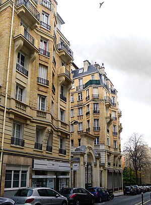
Popular places and events near this IP address

Porte de Clignancourt station
Metro station in Paris, France
Distance: Approx. 921 meters
Latitude and longitude: 48.89694444,2.345
Porte de Clignancourt (French pronunciation: [pɔʁt də kliɲɑ̃kuʁ]) is a station of the Paris Métro, the northern terminus of line 4, situated in the 18th Arrondissement.

Garibaldi station (Paris Métro)
Underground station in Paris
Distance: Approx. 718 meters
Latitude and longitude: 48.90639,2.33194
Garibaldi (French pronunciation: [ɡaʁibaldi] ) is a station on line 13 of the Paris Métro in the commune of Saint-Ouen.

Porte de Saint-Ouen station
Metro station in Paris, France
Distance: Approx. 505 meters
Latitude and longitude: 48.89666667,2.32861111
Porte de Saint-Ouen (French pronunciation: [pɔʁt də sɛ̃t‿wɛ̃]) is a station on line 13 of the Paris Métro on the border of the 17th and 18th arrondissements. Unusually it has an escalator directly linking the platform to the street at the exit to the Rue Leibniz.

Guy Môquet station
Metro station in Paris, France
Distance: Approx. 973 meters
Latitude and longitude: 48.89222222,2.32722222
Guy Môquet (French pronunciation: [ɡi mokɛ]) is a station on Line 13 of the Paris Métro. It is located on the border between the 17th arrondissement and 18th arrondissement, on the line's northeastern branch.

Radio Nova (France)
French radio station
Distance: Approx. 288 meters
Latitude and longitude: 48.9004118,2.3371903
Radio Nova (or simply Nova) is a radio station broadcast from Paris, created in 1981 by Jean-François Bizot. Its playlist is characterized by non-mainstream or underground artists of various music genres, such as electro, new wave, reggae, jazz, hip hop and world music.
Rue Marcadet
Distance: Approx. 939 meters
Latitude and longitude: 48.89166667,2.33527778
Rue Marcadet is a road that stretches the north side of the Butte Montmartre in Paris, France. It is located in the 18th arrondissement.

Stade Bauer
Football stadium in Saint-Ouen-sur-Seine, France
Distance: Approx. 852 meters
Latitude and longitude: 48.90583333,2.34083333
The Stade Bauer is a football stadium in Saint-Ouen-sur-Seine in the northern suburbs of Paris. The stadium is mainly used by Red Star F.C. who currently play in Ligue 2 from 2024–25 but have tasted success in the Coupe de France, winning it on five occasions (1921, 1922, 1923, 1928, 1942).

Saint-Ouen station (Paris RER)
Railway station in Saint-Ouen, France
Distance: Approx. 985 meters
Latitude and longitude: 48.90527778,2.3225
Saint-Ouen is a station in Paris' express suburban rail system, the RER. It is situated in Saint-Ouen, in the département of Seine-Saint-Denis.

Thiers wall
Former defensive wall in Paris
Distance: Approx. 999 meters
Latitude and longitude: 48.89995,2.34695
The Thiers wall (Enceinte de Thiers) was the last of the defensive walls of Paris. It was an enclosure constructed between 1841 and 1846 and was proposed by the French prime minister Adolphe Thiers but was actually implemented by his successor. The 33 kilometres (21 mi) long wall and ditch made a complete circuit around the city as it stood at the time of the July Monarchy.

Square des Épinettes
Distance: Approx. 805 meters
Latitude and longitude: 48.89430556,2.32652778
The Square des Épinettes is a green space in the Épinettes district of Paris (17th arrondissement). It was created in 1893 by Jean-Camille Formigé. Two sculptures in the garden represent famous personalities of the area : Maria Deraismes, a feminist, and Jean Leclaire, an entrepreneur.
Bichat–Claude Bernard Hospital
Hospital in Paris, France
Distance: Approx. 159 meters
Latitude and longitude: 48.89888889,2.33194444
The Bichat–Claude Bernard Hospital (French: Hôpital Bichat-Claude-Bernard [opital biʃa klod bɛʁnaʁ]) is located in the 18th arrondissement of Paris, France, and is operated by Assistance Publique – Hôpitaux de Paris (APHP). It was founded in 1881 as l'Hôpital Bichat (after Xavier Bichat), incorporating the units of nearby Hôpital Claude-Bernard upon the latter's demolition in 1970. The Bichat–Claude Bernard Hospital is also a teaching hospital of the Université Paris Cité.

Saint-Ouen station (Paris Métro)
Metro station in Paris
Distance: Approx. 979 meters
Latitude and longitude: 48.904497,2.321806
Saint-Ouen station (French pronunciation: [sɛ̃t‿wɛ̃]) is a station on the Paris Métro, serving Line 14 and offering a transfer to the RER C via Saint-Ouen RER station. It is located at the limits of the territories of the communes of Saint-Ouen-sur-Seine and Clichy. It is the 304th station of the métro.
Weather in this IP's area
clear sky
18 Celsius
18 Celsius
16 Celsius
19 Celsius
1023 hPa
73 %
1023 hPa
1018 hPa
10000 meters
3.6 m/s
70 degree
06:20:11
21:33:52