Country:
 Liechtenstein
Region:
City:
Latitude and Longitude:
Time Zone:
Postal Code:
IP information under different IP Channel
ip-api
Country
Region
City
ASN
Time Zone
ISP
Blacklist
Proxy
Latitude
Longitude
Postal
Route
IPinfo
Country
Region
City
ASN
Time Zone
ISP
Blacklist
Proxy
Latitude
Longitude
Postal
Route
MaxMind
Country
Region
City
ASN
Time Zone
ISP
Blacklist
Proxy
Latitude
Longitude
Postal
Route
Luminati
Country
 CH
CHASN
Time Zone
Europe/Zurich
ISP
VTX Services SA
Latitude
Longitude
Postal
db-ip
Country
Region
City
ASN
Time Zone
ISP
Blacklist
Proxy
Latitude
Longitude
Postal
Route
ipdata
Country
Region
City
ASN
Time Zone
ISP
Blacklist
Proxy
Latitude
Longitude
Postal
Route
Popular places and events near this IP address

Schellenberg
Municipality in Unterland, Liechtenstein
Distance: Approx. 1762 meters
Latitude and longitude: 47.23360556,9.54805833
Schellenberg (German pronunciation: [ˈʃɛlənˌbɛʁk] ) is a municipality in the lowland area of Liechtenstein, on the banks of the Rhine.
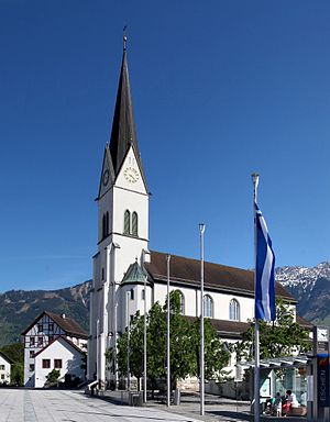
Eschen
Municipality in Unterland, Liechtenstein
Distance: Approx. 2087 meters
Latitude and longitude: 47.21666667,9.51666667
Eschen (German pronunciation: [ˈɛʃn̩] ; High Alemannic: Escha) is a municipality in the north of Liechtenstein. It has a population of 4,466, and covers an area of 10.3 square kilometres (4.0 square miles). It is the fourth-largest town in Liechtenstein by population.
Mauren
Municipality in Unterland, Liechtenstein
Distance: Approx. 835 meters
Latitude and longitude: 47.21666667,9.53333333
Mauren (German pronunciation: [ˈmaʊ̯ʁən] ; High Alemannic: Muura) is a municipality in Liechtenstein that is situated in the north of the country. It has a population of 4,401. The Curta mechanical calculator was produced by Contina AG, in Mauren.
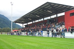
Sportpark Eschen-Mauren
Multi-sport complex in Eschen, Liechtenstein
Distance: Approx. 1439 meters
Latitude and longitude: 47.20583333,9.53777778
Sportpark Eschen-Mauren is a multi-sport complex in Eschen, Liechtenstein. It is currently used mostly for football matches and is the home ground of USV Eschen/Mauren as well as Liechtenstein national youth football teams. It was the national stadium of Liechtenstein national football team until 1998 when the Rheinpark Stadion in Vaduz opened.

Nendeln
Village in Unterland, Liechtenstein
Distance: Approx. 2051 meters
Latitude and longitude: 47.2,9.55
Nendeln is a village located in the municipality of Eschen in Liechtenstein.

Schaanwald
Village in Unterland, Liechtenstein
Distance: Approx. 1705 meters
Latitude and longitude: 47.21666667,9.56666667
Schaanwald is a village in Liechtenstein, located in the municipality of Mauren.

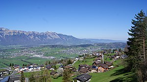
Eschnerberg
Distance: Approx. 1762 meters
Latitude and longitude: 47.23333333,9.55
Eschnerberg, also Eschner Berg, Schellenberg, (especially used in the Austrian village of Feldkirch) is 698 m high (Klocker close to Hinterschellenberg) mountain of seven peaks in the Rhine Valley, on the borderline of Liechtenstein and the Austrian State Voralberg, close to Feldkirch.
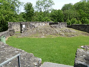
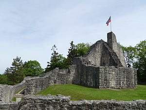
Untere Burg
Castle ruin located in the municipality of Schellenberg, Liechtenstein
Distance: Approx. 1698 meters
Latitude and longitude: 47.2332,9.5424
Untere Burg ("Lower Castle"), also known colloquially as Burg Alt-Schellenberg ("Castle of Alt-Schellenberg"), is a castle ruin located in the municipality of Schellenberg, Liechtenstein. It lies at the edge of a local forest, a few hundred metres north of the main road between Vorderer Schellenberg and Mittleler Schellenberg (two of the burroughs in the village of Alt-Schellenberg). It is freely open to tourists and accessible by foot or mountain bike via a local footpath.
Obere Burg
Castle in Liechtenstein
Distance: Approx. 1823 meters
Latitude and longitude: 47.2329,9.5542
Obere Burg ('Upper Castle'), also known colloquially as Burg Neu-Schellenberg ('Castle of Neu-Schellenberg'), is a castle ruin located in the municipality of Schellenberg, Liechtenstein. It lies at the western edge of Hinterschloss, one of the burroughs in the village of Neu-Schellenberg. It is freely open to tourists.
Schaanwald railway station
Railway station serving Liechtenstein
Distance: Approx. 1496 meters
Latitude and longitude: 47.2116,9.5616
Schaanwald was a railway station in Liechtenstein along the Feldkirch–Buchs railway line. It is one of four railway stations in Liechtenstein and located in the village of Schaanwald in the Mauren municipality. The station is currently disused and not served by any train service.

Unterland (electoral district)
Electoral district of Liechtenstein in Schellenberg
Distance: Approx. 1762 meters
Latitude and longitude: 47.23360556,9.54805833
Unterland (German: Wahlkreis Unterland), meaning "lower land", is one of the two electoral districts of Liechtenstein. The district's administrative seat is the town of Schellenberg, due to its historical existence as the Lordship of Schellenberg (German: Herrschaft Schellenberg). It has 10 seats in the Landtag.

Lordship of Schellenberg
Historic state of the Holy Roman Empire
Distance: Approx. 1762 meters
Latitude and longitude: 47.23360556,9.54805833
The Lordship of Schellenberg (German: Herrschaft Schellenberg) was a historic state of the Holy Roman Empire, now located in the Principality of Liechtenstein. Its capital was the town of Schellenberg.
Weather in this IP's area
clear sky
25 Celsius
26 Celsius
22 Celsius
28 Celsius
1022 hPa
73 %
1022 hPa
970 hPa
10000 meters
2.24 m/s
2.68 m/s
335 degree
05:57:03
20:59:19