Country:
 Switzerland
Region:
City:
Latitude and Longitude:
Time Zone:
Postal Code:
IP information under different IP Channel
ip-api
Country
Region
City
ASN
Time Zone
ISP
Blacklist
Proxy
Latitude
Longitude
Postal
Route
IPinfo
Country
Region
City
ASN
Time Zone
ISP
Blacklist
Proxy
Latitude
Longitude
Postal
Route
MaxMind
Country
Region
City
ASN
Time Zone
ISP
Blacklist
Proxy
Latitude
Longitude
Postal
Route
Luminati
Country
CHASN
Time Zone
Europe/Zurich
ISP
VTX Services SA
Latitude
Longitude
Postal
db-ip
Country
Region
City
ASN
Time Zone
ISP
Blacklist
Proxy
Latitude
Longitude
Postal
Route
ipdata
Country
Region
City
ASN
Time Zone
ISP
Blacklist
Proxy
Latitude
Longitude
Postal
Route
Popular places and events near this IP address
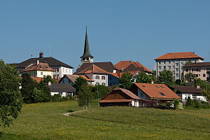
Saignelégier
Municipality in Jura, Switzerland
Distance: Approx. 739 meters
Latitude and longitude: 47.25,7
Saignelégier (French pronunciation: [sɛɲleʒje]) is a municipality in the canton of Jura in Switzerland. It is the seat of the district of Franches-Montagnes. On 1 January 2009, the formerly independent municipalities of Goumois and Les Pommerats merged into Saignelégier.
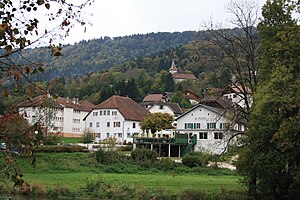
Goumois
Former municipality in Jura, Switzerland
Distance: Approx. 3701 meters
Latitude and longitude: 47.26666667,6.95
Goumois (French pronunciation: [ɡumwa]) was a municipality in the district of Franches-Montagnes in the canton of Jura in Switzerland. On 1 January 2009, the formerly independent municipalities of Goumois and Les Pommerats merged into Saignelégier.

Le Bémont
Municipality in Jura, Switzerland
Distance: Approx. 1918 meters
Latitude and longitude: 47.26666667,7.01666667
Le Bémont is a municipality in the district of Franches-Montagnes in the canton of Jura in Switzerland.
Les Pommerats
Former municipality in Jura, Switzerland
Distance: Approx. 1532 meters
Latitude and longitude: 47.26666667,6.98333333
Les Pommerats (French pronunciation: [le pɔmʁa]) is a municipality in the district of Franches-Montagnes in the canton of Jura in Switzerland. On 1 January 2009, the formerly independent municipalities of Goumois and Les Pommerats merged into Saignelégier.

Muriaux
Municipality in Jura, Switzerland
Distance: Approx. 1211 meters
Latitude and longitude: 47.25,6.98333333
Muriaux is a municipality in the district of Franches-Montagnes in the canton of Jura in Switzerland. On 1 January 2009, the formerly independent municipality of Le Peuchapatte merged into the municipality of Muriaux.
Franches-Montagnes District
District in Switzerland
Distance: Approx. 1211 meters
Latitude and longitude: 47.25,6.98333333
Franches-Montagnes District (German: Freiberge, French: District des Franches-Montagnes, Franc-Comtois: Dichtrict des Fraintches-Montaignes) is one of the three districts of the canton of Jura, Switzerland. Its capital is the town of Saignelégier. The French-speaking district has a population of 10,479 (as of 31 December 2020).
Goumois, Doubs
Commune in Bourgogne-Franche-Comté, France
Distance: Approx. 3566 meters
Latitude and longitude: 47.2617,6.95
Goumois (French pronunciation: [ɡumwa]) is a commune in the department of Doubs, in the eastern French region of Bourgogne-Franche-Comté.

Sommêtres
Mountain in Switzerland
Distance: Approx. 3210 meters
Latitude and longitude: 47.23652,6.96545
The Sommêtres (1,079 m) are a chain of rocks overlooking the Doubs, north of Le Noirmont in the canton of Canton of Jura. The Sommêtres are a popular climbing area.

Le Bémont railway station
Distance: Approx. 1519 meters
Latitude and longitude: 47.26305556,7.01388889
Le Bémont railway station (French: Gare du Bémont) is a railway station in the municipality of Le Bémont, in the Swiss canton of Jura. It is located on the 1,000 mm (3 ft 3+3⁄8 in) La Chaux-de-Fonds–Glovelier line of the Chemins de fer du Jura.

Saignelégier railway station
Distance: Approx. 226 meters
Latitude and longitude: 47.25469444,6.9945
Saignelégier railway station (French: Gare de Saignelégier) is a railway station in the municipality of Saignelégier, in the Swiss canton of Jura. It is located on the 1,000 mm (3 ft 3+3⁄8 in) La Chaux-de-Fonds–Glovelier line of the Chemins de fer du Jura. Historically, the station was the meeting point of the two companies that built the original line, the Chemin de fer Saignelégier-La Chaux-de-Fonds and the Régional Saignelégier–Glovelier, and the Chemins de fer du Jura still maintains depot facilities adjacent to the station.
Muriaux railway station
Distance: Approx. 1623 meters
Latitude and longitude: 47.24388889,6.985
Muriaux railway station (French: Gare de Muriaux) is a railway station in the municipality of Muriaux, in the Swiss canton of Jura. It is located on the 1,000 mm (3 ft 3+3⁄8 in) La Chaux-de-Fonds–Glovelier line of the Chemins de fer du Jura.

Les Emibois railway station
Distance: Approx. 2837 meters
Latitude and longitude: 47.23194444,6.985
Les Emibois railway station (French: Gare des Emibois) is a railway station in the municipality of Muriaux, in the Swiss canton of Jura. It is located on the 1,000 mm (3 ft 3+3⁄8 in) La Chaux-de-Fonds–Glovelier line of the Chemins de fer du Jura.
Weather in this IP's area
clear sky
19 Celsius
19 Celsius
17 Celsius
21 Celsius
1021 hPa
67 %
1021 hPa
911 hPa
10000 meters
0.65 m/s
1.49 m/s
115 degree
06:07:07
21:09:37