Country:
 Switzerland
Region:
City:
Latitude and Longitude:
Time Zone:
Postal Code:
IP information under different IP Channel
ip-api
Country
Region
City
ASN
Time Zone
ISP
Blacklist
Proxy
Latitude
Longitude
Postal
Route
IPinfo
Country
Region
City
ASN
Time Zone
ISP
Blacklist
Proxy
Latitude
Longitude
Postal
Route
MaxMind
Country
Region
City
ASN
Time Zone
ISP
Blacklist
Proxy
Latitude
Longitude
Postal
Route
Luminati
Country
CHASN
Time Zone
Europe/Zurich
ISP
VTX Services SA
Latitude
Longitude
Postal
db-ip
Country
Region
City
ASN
Time Zone
ISP
Blacklist
Proxy
Latitude
Longitude
Postal
Route
ipdata
Country
Region
City
ASN
Time Zone
ISP
Blacklist
Proxy
Latitude
Longitude
Postal
Route
Popular places and events near this IP address

Rickenbach, Thurgau
Municipality in Thurgau, Switzerland
Distance: Approx. 4338 meters
Latitude and longitude: 47.45,9.05
Rickenbach is a municipality in the district of Münchwilen in the canton of Thurgau in Switzerland.

Wilen
Municipality in Thurgau, Switzerland
Distance: Approx. 4306 meters
Latitude and longitude: 47.45,9.03333333
Wilen is a municipality in the district of Münchwilen in the canton of Thurgau in Switzerland. Prior to Thurgau's 1998 reorganisation, Wilen was known as Wilen bei Wil and was part of Rickenbach bei Wil, which was then broken up into the municipalities of Rickenbach and Wilen.
Jonschwil
Municipality in St. Gallen, Switzerland
Distance: Approx. 4051 meters
Latitude and longitude: 47.43333333,9.08333333
Jonschwil is a municipality in the Wahlkreis (constituency) of Wil in the canton of St. Gallen in Switzerland.

Ganterschwil
Former municipality in St. Gallen, Switzerland
Distance: Approx. 4524 meters
Latitude and longitude: 47.38333333,9.08333333
Ganterschwil is a former municipality in the Wahlkreis (constituency) of Toggenburg in the canton of St. Gallen in Switzerland. On 1 January 2013 the former municipalities of Bütschwil and Ganterschwil merged to form the new municipality of Bütschwil-Ganterschwil.

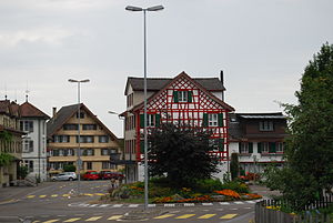
Kirchberg, St. Gallen
Municipality in St. Gallen, Switzerland
Distance: Approx. 1391 meters
Latitude and longitude: 47.4,9.03333333
Kirchberg is a municipality in the Wahlkreis (constituency) of Toggenburg in the canton of St. Gallen in Switzerland.

Lütisburg
Municipality in St. Gallen, Switzerland
Distance: Approx. 3497 meters
Latitude and longitude: 47.4,9.08333333
Lütisburg is a municipality in the Wahlkreis (constituency) of Toggenburg in the canton of St. Gallen in Switzerland.

Bettenauer Weiher
Reservoir in Oberuzwil, Canton of St. Gallen
Distance: Approx. 5178 meters
Latitude and longitude: 47.43,9.10333333
Bettenauer Weiher (or Bettenauerweier, coll. "Betti") is a reservoir between Jonschwil and Oberuzwil in the Canton of St. Gallen, Switzerland.

Alttoggenburg District
Defunct district of St. Gallen, Switzerland
Distance: Approx. 1391 meters
Latitude and longitude: 47.4,9.03333333
Alttoggenburg District (German: Bezirk Alttoggenburg) is a former district of the canton of St. Gallen in Switzerland. The district existed from its formation in 1831 until the canton's 14 districts (German: Bezirke) were reorganized into 8 constituencies (Wahlkreise) on January 1, 2003.

Bazenheid railway station
Distance: Approx. 2179 meters
Latitude and longitude: 47.41012806,9.06904194
Bazenheid railway station (German: Bahnhof Bazenheid) is a railway station in Kirchberg, in the Swiss canton of St. Gallen. It is an intermediate stop on the Wil–Ebnat-Kappel line and is served by local trains only.

Lütisburg railway station
Distance: Approx. 3851 meters
Latitude and longitude: 47.38382694,9.07067389
Lütisburg railway station (German: Bahnhof Lütisburg) is a railway station in Lütisburg, in the Swiss canton of St. Gallen. It is an intermediate stop on the Wil–Ebnat-Kappel line and is served by local trains only.
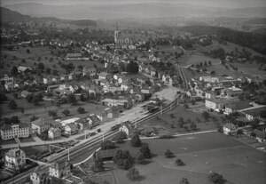
Bazenheid
Distance: Approx. 2141 meters
Latitude and longitude: 47.41222222,9.06861111
Bazenheid (Allemannic German: Bàzehäid) is a village in the municipality of Kirchberg, located in the canton of St. Gallen. As of 2013, a population of 3560 lives there and it contains approximately 30% foreigners.

Schwarzenbach railway station
Disused railway station in Switzerland
Distance: Approx. 4305 meters
Latitude and longitude: 47.44516667,9.06858333
Schwarzenbach SG railway station (German: Bahnhof Schwarzenbach) was a railway station in Schwarzenbach in the municipality of Jonschwil in the canton of St. Gallen (SG), Switzerland. It was located on the St.
Weather in this IP's area
scattered clouds
24 Celsius
24 Celsius
22 Celsius
26 Celsius
1021 hPa
66 %
1021 hPa
940 hPa
10000 meters
1.89 m/s
2.31 m/s
31 degree
29 %
05:58:25
21:01:58