Country:
 Portugal
Region:
City:
Latitude and Longitude:
Time Zone:
Postal Code:
IP information under different IP Channel
ip-api
Country
Region
City
ASN
Time Zone
ISP
Blacklist
Proxy
Latitude
Longitude
Postal
Route
IPinfo
Country
Region
City
ASN
Time Zone
ISP
Blacklist
Proxy
Latitude
Longitude
Postal
Route
MaxMind
Country
Region
City
ASN
Time Zone
ISP
Blacklist
Proxy
Latitude
Longitude
Postal
Route
Luminati
Country
PTRegion
11
City
lisbon
ASN
Time Zone
Europe/Lisbon
ISP
G-Core Labs S.A.
Latitude
Longitude
Postal
db-ip
Country
Region
City
ASN
Time Zone
ISP
Blacklist
Proxy
Latitude
Longitude
Postal
Route
ipdata
Country
Region
City
ASN
Time Zone
ISP
Blacklist
Proxy
Latitude
Longitude
Postal
Route
Popular places and events near this IP address

São Jorge Castle
Historic castle in Lisbon, Portugal
Distance: Approx. 325 meters
Latitude and longitude: 38.71388889,-9.13361111
São Jorge Castle (Portuguese: Castelo de São Jorge; Portuguese pronunciation: [kɐʃˈtɛlu dɨ sɐ̃w̃ ˈʒɔɾʒɨ]), sometimes known in English as Saint George's Castle, is a historic castle in the Portuguese capital of Lisbon, located in the freguesia of Santa Maria Maior. Human occupation of the castle hill dates to at least the 8th century BC while the oldest fortifications on the site date from the 2nd century BC. The hill on which Saint George's Castle stands has played an important part in the history of Lisbon, having served as the location of fortifications occupied successively by Phoenicians, Carthaginians, Romans, and Moors, before its conquest by the Portuguese in the 1147 Siege of Lisbon. Since the 12th century, the castle has variously served as a royal palace, a military barracks, home of the Torre do Tombo National Archive, and now as a national monument and museum.
Monastery of the Mónicas
Building in Lisbon, Portugal
Distance: Approx. 321 meters
Latitude and longitude: 38.71525,-9.13027778
The Monastery of the Mónicas (Portuguese: Mosteiro das Mónicas), located in São Vicente, Lisbon, was a Portuguese nunnery dedicated to the mother of Augustine of Hippo, Saint Monica. It later became a prison.
Santa Justa, Lisbon
Civil parish in Lisbon, Portugal
Distance: Approx. 243 meters
Latitude and longitude: 38.716,-9.136
Santa Justa (Portuguese pronunciation: [ˈsɐ̃tɐ ˈʒuʃtɐ]) (English: Saint Justa) is a former civil parish (freguesia) in the city and municipality of Lisbon, Portugal. It has a population of 700 inhabitants and a total area of 0.24 km². At the administrative reorganization of Lisbon on 8 December 2012 it became part of the parish Santa Maria Maior.
São Jorge de Arroios, Lisbon
Civil parish in Lisbon, Portugal
Distance: Approx. 16 meters
Latitude and longitude: 38.71666667,-9.13333333
São Jorge de Arroios (English: Saint George in Arroios) is a former parish (freguesia) in the municipality of Lisbon, Portugal. With the administrative reorganization of Lisbon on 8 December 2012 it became part of the parish of Arroios.
Igreja do Menino Deus
Catholic church and national monument in Portugal
Distance: Approx. 396 meters
Latitude and longitude: 38.7136,-9.1314
Igreja do Menino Deus is a church in Portugal. It is classified as a National Monument. It was designed by the architect João Antunes.

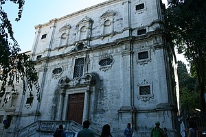
Igreja de São Domingos (Lisbon)
Church in Lisbon, Portugal
Distance: Approx. 490 meters
Latitude and longitude: 38.71473611,-9.13838056
Church of St. Dominic (Portuguese: Igreja de São Domingos) is a Catholic church in Lisbon, Portugal. It is classified as a National Monument.
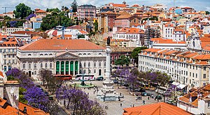
Santa Maria Maior, Lisbon
Civil parish in Lisbon, Portugal
Distance: Approx. 480 meters
Latitude and longitude: 38.713,-9.136
Santa Maria Maior (Portuguese pronunciation: [ˈsɐ̃tɐ mɐˈɾi.ɐ mɐˈjɔɾ]) is a freguesia (civil parish) and district of Lisbon, the capital of Portugal. Located in the historic center of Lisbon, Santa Maria Maior is to the west of São Vicente, east of Misericórdia, and south of Arroios and Santo António. It is home to numerous historic monuments, including Lisbon Cathedral, the Rossio, and the Praça do Comércio, as well as famous neighborhoods, such as the Lisbon Baixa, as well as parts of Bairro Alto and Alfama.

Praça Martim Moniz
Distance: Approx. 314 meters
Latitude and longitude: 38.71547222,-9.13658333
Praça Martim Moniz is a square in Lisbon, Portugal named after Martim Moniz. There are stops on the Lisbon Metro "Martim Moniz" and Lisbon tramway at the square.
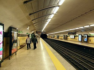
Martim Moniz Station
Metro station in Lisbon, Portugal
Distance: Approx. 200 meters
Latitude and longitude: 38.7168,-9.1357
Martim Moniz is a station on the Green Line of the Lisbon Metro. The station is located in the Martim Moniz Square.

Hospital de São José
Hospital in Lisbon, Portugal
Distance: Approx. 322 meters
Latitude and longitude: 38.7169,-9.1371
Hospital de São José (Portuguese pronunciation: [ɔʃpiˈtal dɨ sɐ̃w ʒuˈzɛ], "Saint Joseph's Hospital") is a public Central Hospital serving the Greater Lisbon area as part of the Central Lisbon University Hospital Centre (CHULC), a state-owned enterprise. Saint Joseph's has operated as a hospital since 1775, following the destruction of its institutional predecessor as the main public hospital in the city of Lisbon, the 15th-century All Saints' Royal Hospital, in the 1755 Lisbon earthquake.

Graça Convent
Catholic building in Lisbon, Portugal
Distance: Approx. 221 meters
Latitude and longitude: 38.716988,-9.13087
Graça Convent (Portuguese: Convento da Graça) is one of the oldest convents in Lisbon. It is located in Largo da Graça, in the parish of São Vicente, on Lisbon's highest hill. It faces a belvedere overlooking the city and the Tagus River.

Convent of the Incarnation (Lisbon)
Former convent in Lisbon, Portugal
Distance: Approx. 495 meters
Latitude and longitude: 38.71644444,-9.13908333
The Convent of the Incarnation (Portuguese: Convento da Encarnação), or the Monastery of the Incarnation of the Commandery of St. Benedict of Avis (Portuguese: Mosteiro da Encarnação das Comendadeiras de São Bento de Avis), is a former convent, constructed in 1630, and located in the parish of Arroios, Lisboa, Portugal. Since 1996, it has been classified as a "Property of Public Interest".
Weather in this IP's area
clear sky
31 Celsius
31 Celsius
28 Celsius
32 Celsius
1012 hPa
42 %
1012 hPa
1006 hPa
10000 meters
4.12 m/s
190 degree
06:34:35
20:51:14