Country:
 Ireland
Region:
City:
Latitude and Longitude:
Time Zone:
Postal Code:
IP information under different IP Channel
ip-api
Country
Region
City
ASN
Time Zone
ISP
Blacklist
Proxy
Latitude
Longitude
Postal
Route
IPinfo
Country
Region
City
ASN
Time Zone
ISP
Blacklist
Proxy
Latitude
Longitude
Postal
Route
MaxMind
Country
Region
City
ASN
Time Zone
ISP
Blacklist
Proxy
Latitude
Longitude
Postal
Route
Luminati
Country
 IM
IMASN
Time Zone
Europe/Isle_of_Man
ISP
CL-1379-14537
Latitude
Longitude
Postal
db-ip
Country
Region
City
ASN
Time Zone
ISP
Blacklist
Proxy
Latitude
Longitude
Postal
Route
ipdata
Country
Region
City
ASN
Time Zone
ISP
Blacklist
Proxy
Latitude
Longitude
Postal
Route
Popular places and events near this IP address

Dublin Castle
Irish government complex and historical castle site in central Dublin
Distance: Approx. 146 meters
Latitude and longitude: 53.3429,-6.2675
Dublin Castle (Irish: Caisleán Bhaile Átha Cliath) is a major Irish government complex, conference centre, and tourist attraction. It is located off Dame Street in central Dublin. It is a former motte-and-bailey castle and was chosen for its position at the highest point of central Dublin.
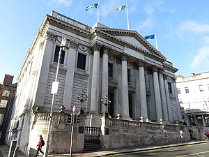
City Hall, Dublin
18th-century civic building in Dublin, Ireland
Distance: Approx. 21 meters
Latitude and longitude: 53.344012,-6.26725
The City Hall, Dublin (Irish: Halla na Cathrach, Baile Átha Cliath), originally the Royal Exchange, is a civic building in Dublin, Ireland. It was built between 1769 and 1779, to the designs of architect Thomas Cooley, and is a notable example of 18th-century architecture in the city. Originally used by the merchants of the city, it is today the formal seat of Dublin City Council.

Chapel Royal, Dublin
Church within Dublin Castle, Ireland
Distance: Approx. 136 meters
Latitude and longitude: 53.3431,-6.2663
The Chapel Royal in Dublin Castle is a 19th-century Gothic revival chapel which served as the official Church of Ireland chapel of the Household of the Lord Lieutenant of Ireland from 1814 until the creation of the Irish Free State in December 1922, which terminated the office of Lord Lieutenant. In 1943, the chapel was reconsecrated as a Catholic place of worship and rededicated as the Church of the Most Holy Trinity, but it has not been used for worship since 1983.

Gaiety School of Acting
Drama school in Dublin, Ireland
Distance: Approx. 141 meters
Latitude and longitude: 53.345014,-6.265579
The Gaiety School of Acting (GSA) is a drama school located on Essex Street West in Temple Bar, Dublin, Ireland. It was founded by theatre director Joe Dowling in 1986. Patrick Sutton, theatre director, was director of the Gaiety School of Acting for 30 years from 1993.
Project Arts Centre
Irish arts venue based in Dublin
Distance: Approx. 110 meters
Latitude and longitude: 53.345,-6.26624
Project Arts Centre is a multidisciplinary arts centre based in Temple Bar, Dublin, which hosts visual arts, theatre, dance, music, and performance.

Olympia Theatre, Dublin
Concert hall and theatre in Dublin, Ireland
Distance: Approx. 73 meters
Latitude and longitude: 53.34427778,-6.26611111
The Olympia Theatre, branded since 2021 for sponsorship purposes as the 3Olympia Theatre, is a concert hall and theatre venue in Dublin, Ireland, located on Dame Street. In addition to Irish acts, the venue has played host to many well-known international artists down through the years such as Charlie Chaplin, Laurel and Hardy, David Bowie, Billy Connolly, Hall & Oates, R.E.M., Gary Numan, Radiohead and Adele. The venue is owned by Caroline Downey of the music promotion company MCD Productions, with naming sponsorship provided under an eight-year deal with telecoms company, 3 (Three Ireland).

Church of St. John the Evangelist, Dublin
Former church in Ireland
Distance: Approx. 138 meters
Latitude and longitude: 53.34435512,-6.2692612
The Church of St. John the Evangelist was a Church of Ireland church located on the west side of Fishamble Street in the centre of Dublin, Ireland. It was founded in the 12th century, and a great many of its parish records survive.
St. Mary del Dam
Distance: Approx. 38 meters
Latitude and longitude: 53.34388889,-6.26743611
St. Mary del Dam is a former parish church in Dublin, Ireland that for many years occupied an important position in the city, and after which Dame Street is named.

Clarence Hotel
Distance: Approx. 122 meters
Latitude and longitude: 53.345263,-6.266782
The Clarence Hotel is a four-star 51-room hotel located at 6–8 Wellington Quay, Dublin, Ireland. It is in the Temple Bar neighbourhood, on the River Liffey. It was built in 1852, and bought by U2 lead singer Bono and lead guitarist The Edge and their business partners in 1992, and opened after refurbishment in 1996.

Garda Museum
Police museum in Dublin, Ireland
Distance: Approx. 138 meters
Latitude and longitude: 53.342964,-6.266992
The Garda Museum (Irish: Músaem an Gharda Síochána) is a police museum located in Dublin, Ireland, located in the Treasury Building of Dublin Castle. Opened in 2017 and designed by Dara Lynne Lenehan, it covers the history of law enforcement in the Republic of Ireland (excluding Northern Ireland), including medieval watchmen, the Baronial Constabulary, County Constabulary, the Dublin Metropolitan Police, the Royal Irish Constabulary and the Civic Guard/Garda Síochána. The then Commissioner Nóirín O'Sullivan officially opened it in December 2016, but legal disputes meant that the public could not visit until August 2017.

Parliament Street, Dublin
Street in Dublin, Ireland
Distance: Approx. 121 meters
Latitude and longitude: 53.3452,-6.2679
Parliament Street (Irish: Sráid na Pairliminte) is a street located on Dublin's Southside. It runs from the junction of Dame Street and Cork Hill on its southern end to the junction of Essex Quay and Wellington Quay on its northern end where it joins directly onto Grattan Bridge and subsequently Capel Street.

Newcomen Bank
Georgian neo-classical building in Dublin, Ireland
Distance: Approx. 51 meters
Latitude and longitude: 53.3438702,-6.2677291
Newcomen Bank is a former Georgian bank building and private residence on the junction of Cork Hill, Lord Edward Street and Castle Street, designed by architect Thomas Ivory in 1781 with the assistance of James Hoban. The bank itself was usually referred to as Newcomen's bank, Newcomen bank or Gleadowe-Newcomen's bank. The building was constructed and named for the Newcomen family.
Weather in this IP's area
broken clouds
20 Celsius
19 Celsius
18 Celsius
21 Celsius
1015 hPa
69 %
1015 hPa
1014 hPa
10000 meters
4.63 m/s
280 degree
75 %
05:33:46
21:29:08