Country:
 Malta
MaltaRegion:
City:
Latitude and Longitude:
Time Zone:
Postal Code:
IP information under different IP Channel
ip-api
Country
Region
City
ASN
Time Zone
ISP
Blacklist
Proxy
Latitude
Longitude
Postal
Route
IPinfo
Country
Region
City
ASN
Time Zone
ISP
Blacklist
Proxy
Latitude
Longitude
Postal
Route
MaxMind
Country
Region
City
ASN
Time Zone
ISP
Blacklist
Proxy
Latitude
Longitude
Postal
Route
Luminati
Country
 IM
IMASN
Time Zone
Europe/Isle_of_Man
ISP
CL-1379-14537
Latitude
Longitude
Postal
db-ip
Country
Region
City
ASN
Time Zone
ISP
Blacklist
Proxy
Latitude
Longitude
Postal
Route
ipdata
Country
Region
City
ASN
Time Zone
ISP
Blacklist
Proxy
Latitude
Longitude
Postal
Route
Popular places and events near this IP address

Senglea
City and local council in South Eastern Region, Malta
Distance: Approx. 507 meters
Latitude and longitude: 35.88777778,14.51694444
Senglea (Maltese: L-Isla [ˈlɪslɐ]), also known by its title Città Invicta (or Civitas Invicta), is a fortified city in the South Eastern Region of Malta. It is one of the Three Cities in the Grand Harbour area, the other two being Cospicua and Vittoriosa, and has a population of approximately 2,720 people. The city's title Città Invicta was given because it managed to resist the Ottoman invasion at the Great Siege of Malta in 1565.
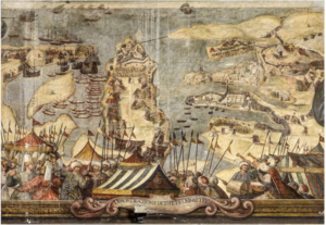
Great Siege of Malta
Ottoman Empire's invasion of Malta in 1565
Distance: Approx. 29 meters
Latitude and longitude: 35.89194444,14.51833333
The Great Siege of Malta (Maltese: L-Assedju l-Kbir) occurred in 1565 when the Ottoman Empire attempted to conquer the island of Malta, then held by the Knights Hospitaller. The siege lasted nearly four months, from 18 May to 8 September 1565. The Knights Hospitaller had been headquartered in Malta since 1530, after being driven out of Rhodes, also by the Ottomans, in 1522, following the siege of Rhodes.
Battle of Malta
1283 battle part of the War of the Sicilian Vespers
Distance: Approx. 350 meters
Latitude and longitude: 35.89483333,14.52041667
The Battle of Malta took place on 8 July 1283 in the entrance to the Grand Harbour, the principal harbour of Malta, as part of the War of the Sicilian Vespers. An Aragonese fleet of galleys, commanded by Roger of Lauria, attacked and defeated a fleet of Angevin galleys commanded by Guillaume Cornut and Bartholomé Bonvin. The Angevin ships arrived in Malta first, and proceeded to relieve the Angevin garrison, which was besieged within the walls of the Castello del Mare.

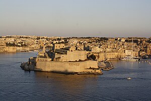
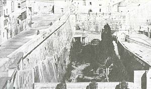
Fort St. Angelo
Bastioned fort in Birgu, Malta
Distance: Approx. 29 meters
Latitude and longitude: 35.89194444,14.51833333
Fort St. Angelo (Maltese: Forti Sant'Anġlu or Fortizza Sant'Anġlu) is a bastioned fort in Birgu, Malta, located at the centre of the Grand Harbour. It was originally built in the medieval period as a castle called the Castrum Maris (English: Castle by the Sea; Italian: Castello al Mare).

Malta Maritime Museum
Maritime museum in Birgu, Malta
Distance: Approx. 571 meters
Latitude and longitude: 35.8875,14.52083333
The Malta Maritime Museum (Maltese: Mużew Marittimu ta' Malta) is a maritime museum in Birgu, Malta. It is housed in the former Royal Naval Bakery, which was built in the 1840s as the main bakery for the Mediterranean Fleet. The museum has a collection of over 20,000 artifacts, and it is the largest museum on the island.

Villa Bighi
Hospital in Kalkara, Malta
Distance: Approx. 568 meters
Latitude and longitude: 35.89308333,14.5245
Royal Naval Hospital Bighi (RNH Bighi) also known as Bighi Hospital, was a major naval hospital located in the small town of Kalkara on the island of Malta. It was built on the site of the gardens of Palazzo Bichi, that was periodically known as Palazzo Salvatore. RNH Bighi served the eastern Mediterranean in the 19th and 20th centuries and, in conjunction with the RN Hospital at Mtarfa, contributed to the nursing and medical care of casualties whenever hostilities occurred in the Mediterranean.

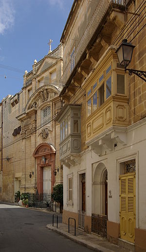
Auberge d'Allemagne, Birgu
Auberge in Birgu, Malta
Distance: Approx. 578 meters
Latitude and longitude: 35.88811111,14.52225
The Auberge d'Allemagne (Maltese: Auberge d'Allemagne) was an auberge in Birgu, Malta. It was built in the 16th century to house knights of the Order of Saint John from the langue of Germany.
Monastery of St. Scholastica
Distance: Approx. 515 meters
Latitude and longitude: 35.8889,14.5223
The Monastery of St. Scholastica is a monastery in Birgu, Malta. The monastery is dedicated to Santa Scholastica, but the church is dedicated to St Anne.
Church of Our Lady of Liesse
Church in Valletta, Malta
Distance: Approx. 549 meters
Latitude and longitude: 35.89508333,14.51336111
The Church of Our Lady of Liesse (Maltese: Knisja tal-Madonna ta' Liesse) is a church in Valletta, Malta. The church was built in 1740 on the site of a 17th-century church. The cupola was built to the design of the Maltese architect Francesco Zammit.
Ġnien is-Sultan
Distance: Approx. 544 meters
Latitude and longitude: 35.8945,14.51297222
Ġnien is-Sultan (Maltese for King's Garden), also known as the Giardino della Marina (Italian for Marina Garden), the Grand Master's Garden or Lascaris Garden, was a garden in Valletta, Malta. It was established in the 17th century by Giovanni Paolo Lascaris, and included a summer residence for the Grand Master. The garden included several Baroque elements designed by Francesco Buonamici.

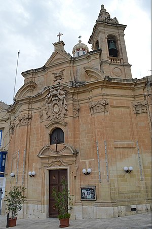
Church of Mary's Nativity within the Fort
Church in Birgu, Malta
Distance: Approx. 30 meters
Latitude and longitude: 35.891935,14.518314
The Church of the Nativity of Mary is a Roman Catholic church located within the historical Fort St. Angelo, in Birgu, Malta.
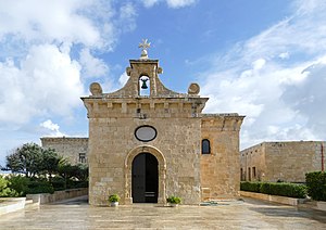
Chapel of St Anne, Fort St Angelo
Church in Birgu, Malta
Distance: Approx. 64 meters
Latitude and longitude: 35.8924,14.51763
The Chapel of St Anne (Maltese: Kappella ta' Sant'Anna) is a Roman Catholic chapel in Fort St Angelo in Birgu, Malta. Its existence was first documented in the 13th century, and according to tradition it stands on the site of an ancient temple. The present building was constructed around 1430 and it was enlarged in 1532 by the Order of St John.
Weather in this IP's area
few clouds
34 Celsius
36 Celsius
34 Celsius
34 Celsius
1016 hPa
46 %
1016 hPa
1016 hPa
10000 meters
2.06 m/s
20 %
06:05:42
20:10:56