Country:
 Ireland
Region:
City:
Latitude and Longitude:
Time Zone:
Postal Code:
IP information under different IP Channel
ip-api
Country
Region
City
ASN
Time Zone
ISP
Blacklist
Proxy
Latitude
Longitude
Postal
Route
IPinfo
Country
Region
City
ASN
Time Zone
ISP
Blacklist
Proxy
Latitude
Longitude
Postal
Route
MaxMind
Country
Region
City
ASN
Time Zone
ISP
Blacklist
Proxy
Latitude
Longitude
Postal
Route
Luminati
Country
 IM
IMASN
Time Zone
Europe/Isle_of_Man
ISP
Interactive Sports Limited
Latitude
Longitude
Postal
db-ip
Country
Region
City
ASN
Time Zone
ISP
Blacklist
Proxy
Latitude
Longitude
Postal
Route
ipdata
Country
Region
City
ASN
Time Zone
ISP
Blacklist
Proxy
Latitude
Longitude
Postal
Route
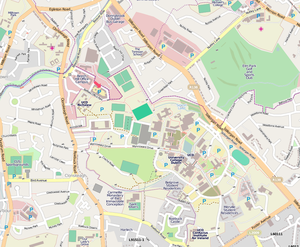
Popular places and events near this IP address

Ailesbury Road
Residential street, Dublin, Ireland
Distance: Approx. 698 meters
Latitude and longitude: 53.320024,-6.22149
Ailesbury Road (Bóthar Aylesbury in Irish), is a tree-lined avenue in the affluent Dublin 4 area in Dublin, Ireland. It links Sydney Parade Station on Sydney Parade Avenue and the Church of the Sacred Heart at Anglesea Road, Donnybrook. Historically, many embassies and diplomatic residences have been located on the road, including the striking residence of the French Ambassador, the embassy of the People's Republic of China, and the Japanese embassy (before it relocated to the nearby Merrion Centre).

St. Vincent's University Hospital
Hospital in Dublin, Ireland
Distance: Approx. 737 meters
Latitude and longitude: 53.31669167,-6.21273611
St. Vincent's Hospital (Irish: Ospidéal Ollscoile Naomh Uinseann) is a teaching hospital located at Elm Park, south of the city of Dublin, Ireland. It is at the junction of Merrion Road and Nutley Lane opposite the Merrion Centre and adjacent to Elm Park Golf Club.

UCD School of Medicine
Distance: Approx. 587 meters
Latitude and longitude: 53.30914,-6.22683
The UCD School of Medicine (Scoil an Leighis UCD) at University College Dublin, Ireland, was founded in 1854. At undergraduate level, the school offers programmes in Medicine MB BCh BAO (undergraduate and graduate entry), BSc Biomedical Health and Life Sciences, and the BSc Radiography. At graduate level, the school UCD offers over 40 programmes for health care professionals.
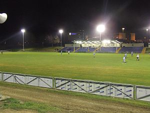
UCD Bowl
Distance: Approx. 530 meters
Latitude and longitude: 53.31027778,-6.22805556
The UCD Bowl, also known as the Belfield Bowl, is a rugby union and football stadium in Dún Laoghaire–Rathdown, Ireland. It is the home ground of University College Dublin R.F.C. in the AIB All Ireland League and League of Ireland Premier Division side University College Dublin A.F.C. It has also hosted training sessions for the Ireland national rugby union team and various touring international teams including the All Blacks. It was one of the venues for the 2017 Women's Rugby World Cup.

RTÉ
Irish public service broadcaster
Distance: Approx. 315 meters
Latitude and longitude: 53.315926,-6.225837
Raidió Teilifís Éireann (pronounced [ˈɾˠadʲiːoː ˈtʲɛlʲəfʲiːʃ ˈeːɾʲən̪ˠ] ; Irish for 'Radio [and] Television of Ireland'; RTÉ) is an Irish public service broadcaster. It both produces and broadcasts programmes on television, radio and online. The radio service began on 1 January 1926, while regular television broadcasts began on 31 December 1961, making it one of the oldest continuously operating public service broadcasters in the world.

Elm Park Golf Club
Distance: Approx. 249 meters
Latitude and longitude: 53.314444,-6.219115
Elm Park Golf & Sports Club operates an 18-hole golf course and tennis club located at Nutley Lane, Donnybrook, Dublin 4, Ireland.

RTÉ Television Centre
Broadcasting campus for Irish network Raidió Teilifís Éireann
Distance: Approx. 207 meters
Latitude and longitude: 53.315634,-6.223251
The RTÉ Television Centre is a television studio building which is owned by Ireland's national public service broadcaster Raidió Teilifís Éireann. It is part of the RTÉ campus located at Donnybrook in South Dublin. The building houses the main production studios for RTÉ Television, the control rooms for all RTÉ's TV channels, and RTÉ's main newsroom.
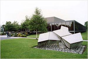
Complex and Adaptive Systems Laboratory
Distance: Approx. 620 meters
Latitude and longitude: 53.308266,-6.223735
Complex and Adaptive Systems Laboratory (CASL) is an interdisciplinary research institute in University College Dublin. It is formed around four research clusters. The institute houses research groups from a number of Schools within UCD, notably computer science.
RTÉ Radio Centre
Radio production centre for Irish broadcaster Raidió Teilifís Éireann
Distance: Approx. 405 meters
Latitude and longitude: 53.316525,-6.226733
The RTÉ Radio Centre is the main production and control centre for the national radio networks of the Irish public service broadcaster Raidió Teilifís Éireann. The building is located on the RTÉ campus at Donnybrook in Dublin. Construction of the building commenced in June 1969 and was completed in April 1971.
University College Dublin
Public research university in Ireland
Distance: Approx. 609 meters
Latitude and longitude: 53.30833333,-6.22222222
University College Dublin (commonly referred to as UCD) (Irish: Coláiste na hOllscoile, Baile Átha Cliath) is a public research university in Dublin, Ireland, and a member institution of the National University of Ireland. With 38,417 students, it is Ireland's largest university, and amongst the most prestigious universities in Europe. Five Nobel Laureates are among UCD's alumni and current and former staff.
Billings Park UCD
Sports pitch at the University College Dublin
Distance: Approx. 519 meters
Latitude and longitude: 53.31040833,-6.22805833
Billings Park is a GAA ground in Dún Laoghaire–Rathdown, Ireland. It is one of the sports pitches at University College Dublin and is located on its Belfield campus. The pitch is named after Dave Billings, a former UCD student who spent 18 years as Head of Gaelic Games in UCD. It was one of the venues for the 2017 Women's Rugby World Cup.

Embassy of Poland, Dublin
Diplomatic mission
Distance: Approx. 771 meters
Latitude and longitude: 53.32002778,-6.21763889
The Polish Embassy in Dublin (Polish: Ambasada Rzeczypospolitej Polskiej w Dublinie) is the diplomatic mission of the Republic of Poland in Ireland. It is located in the capital city of Ireland, Dublin. As of September 2023, the current Polish Ambassador to Ireland is Arkady Rzegocki.
Weather in this IP's area
scattered clouds
18 Celsius
18 Celsius
17 Celsius
19 Celsius
1018 hPa
79 %
1018 hPa
1016 hPa
10000 meters
3.09 m/s
300 degree
40 %
05:33:44
21:28:49