Country:
 Portugal
Region:
City:
Latitude and Longitude:
Time Zone:
Postal Code:
IP information under different IP Channel
ip-api
Country
Region
City
ASN
Time Zone
ISP
Blacklist
Proxy
Latitude
Longitude
Postal
Route
IPinfo
Country
Region
City
ASN
Time Zone
ISP
Blacklist
Proxy
Latitude
Longitude
Postal
Route
MaxMind
Country
Region
City
ASN
Time Zone
ISP
Blacklist
Proxy
Latitude
Longitude
Postal
Route
Luminati
Country
 IM
IMASN
Time Zone
Europe/Isle_of_Man
ISP
CL-1379-14537
Latitude
Longitude
Postal
db-ip
Country
Region
City
ASN
Time Zone
ISP
Blacklist
Proxy
Latitude
Longitude
Postal
Route
ipdata
Country
Region
City
ASN
Time Zone
ISP
Blacklist
Proxy
Latitude
Longitude
Postal
Route
Popular places and events near this IP address

Colégio Militar
Military high school in Lisbon, Portugal
Distance: Approx. 1451 meters
Latitude and longitude: 38.7600116,-9.1858982
Colégio Militar (Portuguese for "Military College") is a military secondary school in Lisbon, Portugal. It was founded by Marechal António Teixeira Rebello in 1803.
Instituto Nacional de Engenharia, Tecnologia e Inovação
Portuguese research institute
Distance: Approx. 1562 meters
Latitude and longitude: 38.7692954,-9.1815165
The Instituto Nacional de Engenharia, Tecnologia e Inovação (National Institute of Engineering, Technology and Innovation), usually known as INETI for short, was a state-run R&D institution in Lisbon, Portugal, with scientific and technological activities in areas like new systems, processes and products; environmental and sustainable management; geological resources and risks; citizen protection, health and safety; space and defence; laboratory support and testing; etc. In 2007 it was merged into the Laboratório Nacional de Energia e Geologia. The Instituto Nacional de Engenharia, Tecnologia e Inovação (National Institute for Engineering, Technology and Innovation) carries out research, testing and technological development.

Brandoa
Civil parish in Lisbon, Portugal
Distance: Approx. 1503 meters
Latitude and longitude: 38.76666667,-9.21666667
Brandoa (Portuguese pronunciation: [bɾɐ̃ˈdoɐ]) is a former civil parish, located in the municipality of Amadora, Portugal. In 2013, the parish merged into the new parish Encosta do Sol. It is situated in the outskirts of Lisbon, with 2,39 km² of area and 15,647 inhabitants (2001).

Carnide
Civil parish in Lisbon, Portugal
Distance: Approx. 1245 meters
Latitude and longitude: 38.76,-9.189
Carnide (Portuguese pronunciation: [kɐɾˈniðɨ]) is a freguesia (civil parish) and typical quarter of Lisbon, the capital city of Portugal. Located in northern Lisbon, Carnide is north of São Domingos de Benfica and Benfica, east of Lumiar, and directly south of Lisbon's border with Odivelas. The population in 2021 was 18,028.
Registro Internacional Naval
Distance: Approx. 1594 meters
Latitude and longitude: 38.76830556,-9.18105556
Registro Internacional Naval (RINAVE) is a maritime classification society, based in Lisbon, Portugal.
Pontinha (Odivelas)
Civil parish in Lisbon, Portugal
Distance: Approx. 1100 meters
Latitude and longitude: 38.77694444,-9.20388889
Pontinha, with an area of 4.64 km2, is a former civil parish in the municipality of Odivelas, Portugal. In 2013, the parish merged into the new parish Pontinha e Famões. It is on the periphery of the metropolitan area of Lisbon, District of Lisbon, within the NUTS III Region of Lisboa e Vale do Tejo.
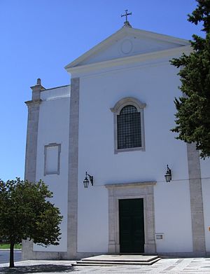
Igreja de Nossa Senhora da Luz (Carnide)
Distance: Approx. 1189 meters
Latitude and longitude: 38.761981,-9.1878248
The Church-Shrine of Our Lady of Light (Portuguese: Igreja-Santuário de Nossa Senhora da Luz) is a Marian shrine and Catholic church in freguesia Carnide of Lisbon, Portugal. It is classified as a National Monument.
Pontinha e Famões
Civil parish in Lisbon, Portugal
Distance: Approx. 415 meters
Latitude and longitude: 38.764,-9.2
Pontinha e Famões is a civil parish in the municipality of Odivelas, Portugal. It was formed in 2013 by the merger of the former parishes Pontinha and Famões. The population in 2011 was 34,143, in an area of 9.22 km².

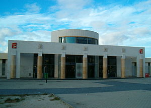
Alfornelos Station
Lisbon Blue Line metro station
Distance: Approx. 932 meters
Latitude and longitude: 38.76055556,-9.205
Alfornelos station is part of the Blue Line of the Lisbon Metro and is located in the Alfornelos neighbourhood of Amadora.

Pontinha Station
Lisbon metro station
Distance: Approx. 712 meters
Latitude and longitude: 38.76166667,-9.19666667
Pontinha station is part of the Blue Line of the Lisbon Metro and is located in the Bairro Mário Madeira neighbourhood of Lisbon, near the border with Amadora and Odivelas.

Carnide Station
Station on the Lisbon Metro
Distance: Approx. 1164 meters
Latitude and longitude: 38.75861111,-9.19277778
Carnide station is part of the Blue Line of the Lisbon Metro and is located near the Bairro da Horta Nova neighbourhood of Lisbon.
Encosta do Sol
Civil parish in Lisbon, Portugal
Distance: Approx. 1195 meters
Latitude and longitude: 38.766,-9.213
Encosta do Sol is a civil parish in the municipality of Amadora, Portugal. It was formed in 2013 by the merger of the former parishes Alfornelos and Brandoa. The population in 2021 was 27.093 , in an area of 2.8 km2.
Weather in this IP's area
few clouds
25 Celsius
25 Celsius
24 Celsius
26 Celsius
1012 hPa
58 %
1012 hPa
1001 hPa
10000 meters
5.66 m/s
310 degree
20 %
06:33:52
20:52:30