Country:
 USA
USARegion:
City:
Latitude and Longitude:
Time Zone:
Postal Code:
IP information under different IP Channel
ip-api
Country
Region
City
ASN
Time Zone
ISP
Blacklist
Proxy
Latitude
Longitude
Postal
Route
IPinfo
Country
Region
City
ASN
Time Zone
ISP
Blacklist
Proxy
Latitude
Longitude
Postal
Route
MaxMind
Country
Region
City
ASN
Time Zone
ISP
Blacklist
Proxy
Latitude
Longitude
Postal
Route
Luminati
Country
 IM
IMASN
Time Zone
Europe/Isle_of_Man
ISP
CL-1379-14537
Latitude
Longitude
Postal
db-ip
Country
Region
City
ASN
Time Zone
ISP
Blacklist
Proxy
Latitude
Longitude
Postal
Route
ipdata
Country
Region
City
ASN
Time Zone
ISP
Blacklist
Proxy
Latitude
Longitude
Postal
Route
Popular places and events near this IP address

Vernon County, Missouri
County in Missouri, United States
Distance: Approx. 1765 meters
Latitude and longitude: 37.85,-94.34
Vernon County is a county located in the western region of the U.S. state of Missouri, on the border with Kansas. As of the 2020 census, the population was 19,707. Its county seat is Nevada.

Nevada, Missouri
City in Missouri, United States
Distance: Approx. 745 meters
Latitude and longitude: 37.84444444,-94.34944444
Nevada ( niv-AY-də) is a city in and the county seat of Vernon County, Missouri, United States. The population was 8,386 at the 2010 census, and 8,254 in the 2018 estimate. The local government has a council-manager model.
Cottey College
Private women's college in Nevada, Missouri, US
Distance: Approx. 1386 meters
Latitude and longitude: 37.8381,-94.3704
Cottey College is a private women's college in Nevada, Missouri. It was founded by Virginia Alice (Cottey) Stockard in 1884. Since 1927 it has been owned and supported by the P.E.O. Sisterhood, a philanthropic women's organization based in Des Moines, Iowa.
Vernon County Courthouse (Missouri)
United States historic place
Distance: Approx. 231 meters
Latitude and longitude: 37.83861111,-94.35722222
Vernon County Courthouse is a historic courthouse located at Nevada, Vernon County, Missouri. It was built between 1906 and 1908. It was listed on the National Register of Historic Places in 1997.
KNEM
Radio station in Nevada, Missouri
Distance: Approx. 3351 meters
Latitude and longitude: 37.86028,-94.38191
KNEM (1240 AM) is a radio station broadcasting a adult contemporary music format. Licensed to Nevada, Missouri, United States, the station is currently owned by Harbit Communications, Inc. The station is co-owned with KNMO-FM, which broadcasts on 97.5 FM. On October 3, 2023, KNEM dropped its simulcast with KNMO-FM and changed its format to adult contemporary, branded as "Sunny 99.9".
KNMO-FM
Radio station in Nevada, Missouri
Distance: Approx. 4705 meters
Latitude and longitude: 37.87928,-94.33772
KNMO-FM (97.5 MHz) is a radio station airing a country music format licensed to Nevada, Missouri. The station is owned by Harbit Communications, Inc.
Birch Branch
Stream in the American state of Missouri
Distance: Approx. 3702 meters
Latitude and longitude: 37.8280947,-94.3943954
Birch Branch is a stream in Vernon County in the U.S. state of Missouri. It is a tributary of Little Dry Wood Creek. Birch Branch most likely was named on account of birch timber in the area.
Landon Branch
Stream in Vernon County in the U.S
Distance: Approx. 6487 meters
Latitude and longitude: 37.7814291,-94.3643944
Landon Branch is a stream in Vernon County in the U.S. state of Missouri. Landon Branch has the name of the local Landon family.
Center Township, Vernon County, Missouri
Township in the US state of Missouri
Distance: Approx. 3642 meters
Latitude and longitude: 37.8072,-94.3461
Center Township is a township in Vernon County, in the U.S. state of Missouri. Center Township was erected in 1855, and named for the fact the geographical center point of Vernon County lies within its borders.

Vernon County Jail, Sheriff's House and Office
United States historic place
Distance: Approx. 313 meters
Latitude and longitude: 37.840145,-94.358049
Vernon County Jail, Sheriff's House and Office, also known as the Bushwhacker Museum, is a historic jail and sheriff's residence located at Nevada, Vernon County, Missouri. The stone building was built in 1871 and consists of: a two-story, rectangular-plan, Federal-style residence; a two-story, four-room office; and a one-story, rectangular jail. The building ceased use as a jail in 1960 and houses a local history museum.: 2 It was listed on the National Register of Historic Places in 1977.
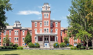
Infirmary Building, Missouri State Hospital Number 3
United States historic place
Distance: Approx. 2404 meters
Latitude and longitude: 37.860514,-94.359117
Infirmary Building, Missouri State Hospital Number 3, also known as the Nevada State Hospital, is a historic hospital building located at Nevada, Vernon County, Missouri. It was built in 1937, as a Public Works Administration (PWA) project. It is an X-shaped Kirkbride Plan building and consists of a four-story central block with four three- and four-story wings.
Nevada High School (Missouri)
Public secondary school in Nevada, Missouri, United States
Distance: Approx. 1208 meters
Latitude and longitude: 37.84485,-94.366427
Nevada High School is a public high school located in Nevada, Missouri. It serves students in grades 9 through 12 and is the only high school in the Nevada R-V School District.
Weather in this IP's area
overcast clouds
25 Celsius
26 Celsius
25 Celsius
27 Celsius
1016 hPa
79 %
1016 hPa
986 hPa
10000 meters
1.34 m/s
2.68 m/s
212 degree
88 %
06:16:55
20:30:41