Country:
 Switzerland
Region:
City:
Latitude and Longitude:
Time Zone:
Postal Code:
IP information under different IP Channel
ip-api
Country
Region
City
ASN
Time Zone
ISP
Blacklist
Proxy
Latitude
Longitude
Postal
Route
IPinfo
Country
Region
City
ASN
Time Zone
ISP
Blacklist
Proxy
Latitude
Longitude
Postal
Route
MaxMind
Country
Region
City
ASN
Time Zone
ISP
Blacklist
Proxy
Latitude
Longitude
Postal
Route
Luminati
Country
CHASN
Time Zone
Europe/Zurich
ISP
VTX Services SA
Latitude
Longitude
Postal
db-ip
Country
Region
City
ASN
Time Zone
ISP
Blacklist
Proxy
Latitude
Longitude
Postal
Route
ipdata
Country
Region
City
ASN
Time Zone
ISP
Blacklist
Proxy
Latitude
Longitude
Postal
Route
Popular places and events near this IP address
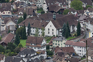
Schwyz
Capital of Schwyz canton, Switzerland
Distance: Approx. 1333 meters
Latitude and longitude: 47.01666667,8.65
Schwyz (German pronunciation: [ʃviːts] ; French: Schwytz; Italian: Svitto) is a town and the capital of the canton of Schwyz in Switzerland. The Federal Charter of 1291 or Bundesbrief, the charter that eventually led to the foundation of Switzerland, can be seen at the Bundesbriefmuseum. The official language of Schwyz is (the Swiss variety of) German, but the main spoken language is the local variant of the Alemannic Swiss German dialect.
Schwyz District
District in Switzerland
Distance: Approx. 1333 meters
Latitude and longitude: 47.01666667,8.65
Schwyz District is a district of the canton of Schwyz, Switzerland. It is both the largest and most populous of the six districts of the canton of Schwyz, accounting for around half its surface area, and 40% of the population. It has a population of 56,125 (as of 31 December 2020).
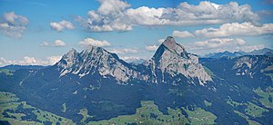
Grosser Mythen
Mountain in the Schwyzer Alps of Central Switzerland
Distance: Approx. 2490 meters
Latitude and longitude: 47.02972222,8.68880556
The Grosser Mythen (also Grosse Mythe) is a mountain in the Schwyzer Alps of Central Switzerland. The mountain lies in the canton of Schwyz, to the east of the town of Schwyz, and to the south of the village of Alpthal in the valley of the river Alp. It is accessible from the Holzegg by a hiking trail which is opened during the summer months only.
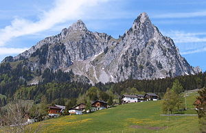
Kleiner Mythen
Mountain in the Schwyzer Alps of Central Switzerland
Distance: Approx. 2601 meters
Latitude and longitude: 47.04069444,8.68477778
The Kleiner Mythen is a mountain in the Schwyzer Alps of Central Switzerland. The mountain lies in the canton of Schwyz, to the east of the town of Schwyz, to the south of the village of Alpthal in the valley of the Alp river, and to the north of the Grosser Mythen.

Ibach, Switzerland
Village in Schwyz, Switzerland
Distance: Approx. 2050 meters
Latitude and longitude: 47.01127778,8.64447222
Ibach is a village in the municipality of Schwyz, itself in the canton of Schwyz in Switzerland. It lies some 1.5 km (0.93 mi) to the south of the town centre of Schwyz, at the point where the road from Schwyz to Brunnen bridges the Muota river. A Swiss knife manufacturer Victorinox, known for its Swiss Army knives, was founded in Ibach, where it operates to this day.

Schwyz railway station
Railway station in Schwyz, Switzerland
Distance: Approx. 1826 meters
Latitude and longitude: 47.02639,8.63213194
Schwyz railway station (German: Bahnhof Schwyz) is a railway station in the municipality of Schwyz, the capital of the canton of Schwyz in Switzerland. Opened in 1882, it is owned and operated by the Swiss Federal Railways, and forms part of the Gotthard railway, which links northern Switzerland and Immensee with Chiasso and Italy, via the Gotthard Tunnel. The station is located in the village of Seewen in the middle of the Schwyz valley, about 2 km (1.2 mi) northwest of the town centre, between the Grosser Mythen and the Urmiberg.
Sparkasse Schwyz
Swiss regional savings bank
Distance: Approx. 762 meters
Latitude and longitude: 47.022,8.651
Sparkasse Schwyz AG is a regional savings bank in the Swiss Canton of Schwyz, founded in 1812 and thus one of the oldest banks in continuous operation in the world. The bank has offices in Schwyz, Brunnen, Goldau and Küssnacht am Rigi. As of 2008, it had 61 employees.
Hochstuckli
Mountain in Switzerland
Distance: Approx. 3483 meters
Latitude and longitude: 47.05777778,8.66972222
The Hochstuckli (1,566 m) is a mountain of the Schwyzer Alps, overlooking Mostelberg in the canton of Schwyz. In winter the mountain is part of a ski area. A ski-lift climbs to a height of 1,486 metres.
Battle of Schwyz
Distance: Approx. 1333 meters
Latitude and longitude: 47.01666667,8.65
Battle of Schwyz im Muttenthal occurred on 14–15 August 1799 between French forces commanded by General of Division André Masséna and Major General von Franz Jellachich's brigade. The French lost 500 killed, wounded or missing, and the Austrians lost 2,400 men and six guns.

Seewen, Schwyz
Village in Schwyz, Switzerland
Distance: Approx. 1985 meters
Latitude and longitude: 47.02916667,8.63
Seewen is a village in the municipality of Schwyz, itself in the canton of Schwyz in Switzerland. It lies some 2 km (1.2 mi) to the west of the town centre of Schwyz, and near the shore of Lake Lauerz. The outfall stream of the lake, the Seeweren, passes through the village on its way to join the Muota river.

Rickenbach, Schwyz
Village in Schwyz, Switzerland
Distance: Approx. 1821 meters
Latitude and longitude: 47.01453889,8.66993333
Rickenbach is a village in the municipality of Schwyz, itself in the canton of Schwyz in Switzerland. It lies some 1.5 km (0.93 mi) to the east of the town centre of Schwyz. The Rotenfluebahn, a gondola lift, links Rickenbach with the summit of the Rotenfluh mountain, which is, in summer, a popular vantage point over the Lake Lucerne region, and, in winter, a ski area.

Museum of the Swiss Charters of Confederation
History museum in Schwyz, Switzerland
Distance: Approx. 892 meters
Latitude and longitude: 47.0219,8.6483
The Museum of the Swiss Charters of Confederation (German: Bundesbriefmuseum; up to 1992 the Federal Charter Archive) is a history museum in Schwyz. It was built in 1936 as a national shrine for the Federal Charter of 1291, which was believed to be the founding document of the Swiss Confederation. Today, the museum explains the national myth and the actual history of the Old Swiss Confederacy.
Weather in this IP's area
clear sky
27 Celsius
28 Celsius
25 Celsius
31 Celsius
1020 hPa
55 %
1020 hPa
951 hPa
10000 meters
2.63 m/s
2.1 m/s
337 degree
06:01:13
21:02:15