Country:
 Romania
Region:
City:
Latitude and Longitude:
Time Zone:
Postal Code:
IP information under different IP Channel
ip-api
Country
IPinfo
Country
MaxMind
Country
Luminati
Country
ROASN
Time Zone
Europe/Bucharest
ISP
Orange Romania S.A.
Latitude
Longitude
Postal
db-ip
Country
ipdata
Country
Popular places and events near this IP address
Hunedoara
Municipality in Romania
Distance: Approx. 2702 meters
Latitude and longitude: 45.76972222,22.92027778
Hunedoara (Romanian: [huneˈdo̯ara] ; German: Eisenmarkt; Hungarian: Vajdahunyad [ˈvɒjdɒhuɲɒd] ) is a city in Hunedoara County, Transylvania, Romania. It is located in southwestern Transylvania near the Poiana Ruscă Mountains, and administers five villages: Boș (Bós), Groș (Grós), Hășdat (Hosdát; Hochstätten), Peștișu Mare (Alpestes), and Răcăștia (Rákosd). The city includes the most important Gothic-style secular building in Transylvania: the Hunyad Castle, which is closely connected with the Hunyadi family.
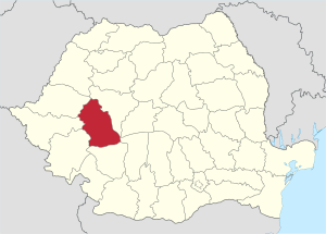
Hunedoara County
County of Romania
Distance: Approx. 4072 meters
Latitude and longitude: 45.78,22.93
Hunedoara County (Romanian pronunciation: [huneˈdo̯ara] ) is a county (județ) of Romania, in Transylvania, with its capital city at Deva. The county is part of the Danube–Criș–Mureș–Tisa Euroregion.

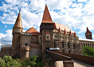
Corvin Castle
15th-century castle in Romania
Distance: Approx. 911 meters
Latitude and longitude: 45.74916667,22.88833333
Corvin Castle, also known as Hunyadi Castle or Hunedoara Castle (Romanian: Castelul Huniazilor or Castelul Corvinilor; Hungarian: Vajdahunyadi vár), is a Gothic-Renaissance castle in Hunedoara, Romania. It is considered one of the largest castles in Europe and is featured as one of the Seven Wonders of Romania.
Peștiș (Cerna)
River in Hunedoara County, Romania
Distance: Approx. 5567 meters
Latitude and longitude: 45.7958,22.9288
The Peștiș is a left tributary of the river Cerna in Romania. It discharges into the Cerna in Peștișu Mare. Its length is 22 km (14 mi) and its basin size is 54 km2 (21 sq mi).
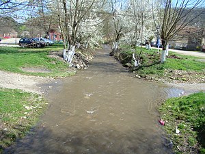
Zlaști
River in Hunedoara County, Romania
Distance: Approx. 545 meters
Latitude and longitude: 45.7491,22.8931
The Zlaști is a left tributary of the river Cerna in Romania. It discharges into the Cerna in the city Hunedoara. Its length is 33 km (21 mi) and its basin size is 79 km2 (31 sq mi).
Govăjdia
River in Hunedoara County, Romania
Distance: Approx. 5449 meters
Latitude and longitude: 45.7035,22.8781
The Govăjdia (also: Runc) is a left tributary of the river Cerna in Romania. It discharges into the Cerna in Teliucu Superior, downstream from the Cinciș Dam. Its length is 37 km (23 mi) and its basin size is 155 km2 (60 sq mi).

Teliucu Inferior
Commune in Hunedoara, Romania
Distance: Approx. 3930 meters
Latitude and longitude: 45.71666667,22.88333333
Teliucu Inferior (Hungarian: Alsótelek, German: Untertelek) is a commune in Hunedoara County, Transylvania, Romania. It is composed of four villages: Cinciș-Cerna (Csolnakoscserna), Izvoarele (Lindzsina), Teliucu Inferior, and Teliucu Superior (Felsőtelek). Iron mining began there in Roman times.

Pestișu Mic
Commune in Hunedoara, Romania
Distance: Approx. 5714 meters
Latitude and longitude: 45.8,22.88333333
Pestișu Mic (Hungarian: Felsőpestes) is a commune in Hunedoara County, Transylvania, Romania. It is composed of nine villages: Almașu Mic (Keresztényalmás), Ciulpăz (Csulpesz), Cutin (Kutyén), Dumbrava (Erdőhát), Josani (Zsoszány), Mănerău (Magyarosd), Nandru (Nándor), Pestișu Mic and Valea Nandrului (Nándorválya).
Castra of Hunedoara
Fort in the Roman province of Dacia
Distance: Approx. 915 meters
Latitude and longitude: 45.74897222,22.88831389
The castra of Hunedoara was a fort in the Roman province of Dacia located on Sânpetru Hill, Hunedoara, Romania. The garrison was a vexillation of Legion XIII Gemina.
Iancu de Hunedoara National College
Public school in Hunedoara, Hunedoara County, Romania
Distance: Approx. 357 meters
Latitude and longitude: 45.750772,22.904463
"Iancu de Hunedoara" National College (Colegiul Național "Iancu de Hunedoara") is a high school in Hunedoara, Romania.

Călan steel works
Former steel mill in Călan, Romania
Distance: Approx. 7464 meters
Latitude and longitude: 45.74166667,22.99533333
The Călan steel works, formerly the Victoria Steel Works Călan (Romanian: Combinatul Siderurgic "Victoria" Călan), were a steel mill in the Transylvanian town of Călan, Romania. Begun around 1870, when the area was part of Austria-Hungary, the works underwent a powerful expansion following nationalization in 1948 by the nascent Communist regime, making a vital contribution to the growth of the town. Privatization in the late 1990s proved unsuccessful, and the works were largely abandoned within a decade, leading to economic hardship for Călan.

Transfiguration Church, Hunedoara
Heritage site in Hunedoara County, Romania
Distance: Approx. 411 meters
Latitude and longitude: 45.74722,22.89652
The Transfiguration Church (Romanian: Biserica Schimbarea la Față) is a Romanian Orthodox church located at 35 Popa Șapcă Street, Hunedoara, Romania. It is dedicated to the Feast of the Transfiguration. The town’s old Orthodox church was taken over by the newly established Romanian Greek-Catholic Church after 1701.
Weather in this IP's area
clear sky
25 Celsius
25 Celsius
25 Celsius
25 Celsius
1017 hPa
52 %
1017 hPa
990 hPa
10000 meters
0.93 m/s
1.08 m/s
87 degree
05:48:54
21:18:17