Country:
 USA
USARegion:
City:
Latitude and Longitude:
Time Zone:
Postal Code:
IP information under different IP Channel
ip-api
Country
Region
City
ASN
Time Zone
ISP
Blacklist
Proxy
Latitude
Longitude
Postal
Route
IPinfo
Country
Region
City
ASN
Time Zone
ISP
Blacklist
Proxy
Latitude
Longitude
Postal
Route
MaxMind
Country
Region
City
ASN
Time Zone
ISP
Blacklist
Proxy
Latitude
Longitude
Postal
Route
Luminati
Country
USASN
Time Zone
America/Chicago
ISP
CL-1379-14537
Latitude
Longitude
Postal
db-ip
Country
Region
City
ASN
Time Zone
ISP
Blacklist
Proxy
Latitude
Longitude
Postal
Route
ipdata
Country
Region
City
ASN
Time Zone
ISP
Blacklist
Proxy
Latitude
Longitude
Postal
Route
Popular places and events near this IP address

Summerlin South, Nevada
CDP in Nevada, United States
Distance: Approx. 2105 meters
Latitude and longitude: 36.12638889,-115.33277778
Summerlin South, also seen on maps as South Summerlin, is a census-designated place (CDP) in Clark County, Nevada, United States, on the western edge of the Las Vegas Valley and adjacent to the Red Rock Canyon National Conservation Area. It is so named because it is a southward extension of the master-planned community of Summerlin. Nearly all of Summerlin South is in ZIP code 89135.

Red Rock Casino, Resort & Spa
Casino resort in Las Vegas, Nevada
Distance: Approx. 2724 meters
Latitude and longitude: 36.15444444,-115.33027778
Red Rock Resort is a hotel and casino in Summerlin South, Nevada, located in the Las Vegas Valley. It is owned and operated by Station Casinos on 59.43 acres (24.05 ha) located in the Downtown Summerlin neighborhood. It is Station Casinos' flagship property, and the company's corporate headquarters is located on the property.

Palo Verde High School
Public high school
Distance: Approx. 4156 meters
Latitude and longitude: 36.17138889,-115.33305556
Palo Verde High School is a high school in Las Vegas, Nevada, United States. The school was built in 1996 with an adjacent 10 portable classrooms located in Summerlin, a rapidly growing suburban community in the western portion of the City of Las Vegas and unincorporated Clark County. The origin of the school's name comes from the surrounding palo verde trees.

Faith Lutheran Middle School & High School
Private, coeducational school in Las Vegas, Nevada, United States
Distance: Approx. 3666 meters
Latitude and longitude: 36.15388889,-115.31666667
Faith Lutheran Middle School & High School is a private Christian college-preparatory school located in Summerlin, Nevada. The school, which was founded in 1979, serves grades 6-12 and is affiliated with the Lutheran Church–Missouri Synod. The school is the largest non-public school in Nevada, with over 2,000 students.
Las Vegas Art Museum
Former art museum in Nevada
Distance: Approx. 4195 meters
Latitude and longitude: 36.14526,-115.30629
The Las Vegas Art Museum was an art museum in Las Vegas, Nevada. It was formerly located in a building shared with the Sahara West Library branch of the Las Vegas-Clark County Library District in Las Vegas, NV. The museum closed in 2009. The Las Vegas Art Museum was "dedicated to engaging visitors in the international culture of contemporary art." The museum provided the public with publications, lectures, educational and outreach programs.

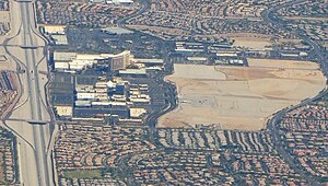
Downtown Summerlin (shopping center)
Shopping mall in Nevada, U.S.
Distance: Approx. 2148 meters
Latitude and longitude: 36.14944444,-115.33333333
The Downtown Summerlin shopping center or DTS is an outdoor shopping, dining, and entertainment center. It is a part of the greater Downtown Summerlin area, a 400-acre (160 ha) development which lies within the community of Summerlin South on the western outskirts of Las Vegas, Nevada. The shopping center contains 1,600,000 square feet (150,000 m2) and is located on 106 acres (43 ha).

The Alexander Dawson School at Rainbow Mountain
Independent day school in Summerlin, Nevada, United States
Distance: Approx. 2230 meters
Latitude and longitude: 36.12672982,-115.33082846
The Alexander Dawson School at Rainbow Mountain or Dawson is a private independent, college-preparatory, and day school in Summerlin, Nevada. The Alexander Dawson School at Rainbow Mountain provides co-educational and secular education to over 520 students from preschool through eighth grade.
Downtown Summerlin
Distance: Approx. 2510 meters
Latitude and longitude: 36.152077,-115.330809
Downtown Summerlin is a 400-acre (160 ha) mixed-use development in Summerlin, Nevada, a suburban area on the western outskirts of Las Vegas. It includes the Downtown Summerlin shopping center, office space, and several apartment properties. Downtown Summerlin was developed by The Howard Hughes Corporation, which also developed the Summerlin community.

Nevada's 8th Senate district
American legislative district
Distance: Approx. 4875 meters
Latitude and longitude: 36.15,-115.3
Nevada's 8th Senate district is one of 21 districts in the Nevada Senate. It has been represented by Democrat Marilyn Dondero Loop since 2018, succeeding Republican-turned-independent Patricia Farley.
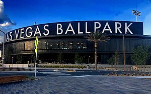
Las Vegas Ballpark
Baseball stadium in Summerlin, Nevada
Distance: Approx. 2620 meters
Latitude and longitude: 36.15227778,-115.32941667
Las Vegas Ballpark is a baseball stadium in the Summerlin South region of Las Vegas, Nevada, United States. It is the home field for the Las Vegas Aviators of the Pacific Coast League, who are currently affiliated with the Oakland Athletics. The stadium, along with its primary tenant, is owned by the Howard Hughes Corporation.

City National Arena
Ice hockey arena in Summerlin, Nevada.
Distance: Approx. 2747 meters
Latitude and longitude: 36.154,-115.3294
City National Arena is the practice facility and team headquarters of the Vegas Golden Knights of the National Hockey League. City National Arena opened on September 18, 2017, and is located in Summerlin South, Nevada, a suburb of Las Vegas. It contains the headquarters for the team, a team store, and a MacKenzie River Pizza, Grill & Pub restaurant, among other features.
Killings of Sydney Land and Nehemiah Kauffman
2016 unsolved double murder
Distance: Approx. 4646 meters
Latitude and longitude: 36.10888889,-115.31405556
On October 26, 2016, Sydney Land and her boyfriend Nehemiah Kauffman were shot and killed in her apartment in Las Vegas, Nevada. Their bodies were found the next day. Initially, Las Vegas Metropolitan Police Department (also known as Metro) announced that they had no motive and no suspects in the case.
Weather in this IP's area
smoke
30 Celsius
28 Celsius
29 Celsius
31 Celsius
1007 hPa
19 %
1007 hPa
904 hPa
10000 meters
6.69 m/s
9.77 m/s
210 degree
05:44:54
19:50:41