Country:
 British Virgin Islands
Region:
City:
Latitude and Longitude:
Time Zone:
Postal Code:
IP information under different IP Channel
ip-api
Country
Region
City
ASN
Time Zone
ISP
Blacklist
Proxy
Latitude
Longitude
Postal
Route
IPinfo
Country
Region
City
ASN
Time Zone
ISP
Blacklist
Proxy
Latitude
Longitude
Postal
Route
MaxMind
Country
Region
City
ASN
Time Zone
ISP
Blacklist
Proxy
Latitude
Longitude
Postal
Route
Luminati
Country
 US
USASN
Time Zone
America/Chicago
ISP
CL-1379-14537
Latitude
Longitude
Postal
db-ip
Country
Region
City
ASN
Time Zone
ISP
Blacklist
Proxy
Latitude
Longitude
Postal
Route
ipdata
Country
Region
City
ASN
Time Zone
ISP
Blacklist
Proxy
Latitude
Longitude
Postal
Route
Popular places and events near this IP address

Tortola
Largest of the British Virgin Islands
Distance: Approx. 752 meters
Latitude and longitude: 18.42333333,-64.61805556
Tortola () is the largest and most populated island of the British Virgin Islands, a group of islands that form part of the archipelago of the Virgin Islands. It has a surface area of 55.7 square kilometres (21.5 square miles) with a total population of 23,908, with 9,400 residents in Road Town. Mount Sage is its highest point at 530 metres (1,740 feet) above sea level.
A. O. Shirley Recreation Ground
Sports stadium. Cricket ground in British Virgin Islands.
Distance: Approx. 1164 meters
Latitude and longitude: 18.42638889,-64.62083333
The AO Shirley Recreation Ground is a multi-use stadium in Road Town, British Virgin Islands. It is currently used mostly for football matches and usually hosts the British Virgin Islands national football team's games. The stadium holds 1,500 people.

Fort Charlotte, Tortola
Distance: Approx. 783 meters
Latitude and longitude: 18.4135,-64.6233
Fort Charlotte is a fort built on Harrigan's Hill (above Macnamara), Tortola, British Virgin Islands. The fort was named after Queen Charlotte.
Fort Burt
Former colonial fort, hotel & restaurant
Distance: Approx. 473 meters
Latitude and longitude: 18.4129,-64.6147
Fort Burt is a colonial fort that was erected on the southwest edge of Road Town, Tortola in the British Virgin Islands above Road Reef Marina. The site is now a hotel and restaurant of the same name, and relatively little of the original structure remains. However, one of the original cannons has survived and stands on the veranda of the hotel, vigilantly looking over the harbour.

Fort George, Tortola
Distance: Approx. 1456 meters
Latitude and longitude: 18.426,-64.607
Fort George is a colonial fort which was erected on the northeast edge of Road Town, Tortola in the British Virgin Islands above Baugher's Bay. The site is now a ruin. The original structure is believed by some to have been built at an unascertained date by the original Dutch settlers of the islands to protect slave pens that were built in Port Purcell below.
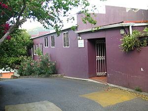
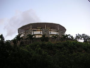
Road Town Fort
Distance: Approx. 439 meters
Latitude and longitude: 18.4203,-64.6184
Road Town Fort is a colonial fort which was erected on Russell Hill in Road Town, Tortola in the British Virgin Islands above the town's main wharf. In historical records it is sometimes referred to as Fort Road Town. The fort subsequently fell into ruin, and in the 1960s the Bougainvillea clinic (known locally as the Purple Palace for fairly obvious reasons) was built on top of the old structure.

Wickams Cay
Distance: Approx. 622 meters
Latitude and longitude: 18.41277778,-64.6125
Wickams Cay and Little Wickam's Cay (sometimes spelled Wickhams Cay) were former islands of the British Virgin Islands in the Caribbean. They were both located in Road Harbour, but due to reclamation of land projects in Tortola, Wickhams Cay now makes up part of Road Town, the capital of the British Virgin Islands. The areas are known as Wickhams Cay and Wickhams Cay II (for Little Wickhams Cay).
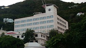
Peebles Hospital
Hospital in Tortola, British Virgin Islands
Distance: Approx. 257 meters
Latitude and longitude: 18.4171,-64.6191
Peebles Hospital is the main public hospital in the British Virgin Islands. The hospital is located in the capital, Road Town, on the island of Tortola. It was founded in 1922 by Major H.W. Peebles, and was originally known as the Cottage Hospital.
ZCBN
Radio station in Tortola, British Virgin Islands
Distance: Approx. 1078 meters
Latitude and longitude: 18.4246,-64.6226
ZCBN/92.3 was an F.M. radio station broadcasting from the British Virgin Islands, owned by the Caribbean Broadcast Network. It broadcasts a variety of different kinds of music, described on its website as a mix of "pop, classic country, classic rock & easy listening...blended with reggae & calypso". Its sister station is ZBTV. ZCBN’s most recent licence expired on 29 June 2021.
ZBVI
Radio station in Tortola, British Virgin Islands
Distance: Approx. 1539 meters
Latitude and longitude: 18.4244,-64.6046
ZBVI 780 is an A.M. radio station broadcasting from Tortola, British Virgin Islands. Listed in the F.C.C. database with the callsign of ZBV, the station calls itself ZBVI on-air. Although the station is located in the British Virgin Islands the broadcast reach extends to Anguilla, the United States Virgin Islands and Puerto Rico's islands Culebra and Vieques.
St. William's Church, Road Town
Church in Tortola, British Virgin Islands
Distance: Approx. 579 meters
Latitude and longitude: 18.4215,-64.6188
St. William's Church is a Catholic church in Road Town, the capital of the British Virgin Islands. Although the community was founded in 1957 with a small chapel it was completed in 1993 and the first church much larger current building dates from 1999 and included the construction of a parish hall and administrative offices.
Elmore Stoutt High School
Secondary school in British Virgin Islands
Distance: Approx. 1152 meters
Latitude and longitude: 18.4254834,-64.6224675
Elmore Stoutt High School (ESHS) is a grade 7-12 secondary school in Road Town, Tortola, British Virgin Islands.
Weather in this IP's area
few clouds
31 Celsius
38 Celsius
31 Celsius
31 Celsius
1016 hPa
70 %
1016 hPa
1016 hPa
10000 meters
2.57 m/s
50 degree
20 %
05:54:41
18:55:01