Country:
 USA
USARegion:
City:
Latitude and Longitude:
Time Zone:
Postal Code:
IP information under different IP Channel
ip-api
Country
Region
City
ASN
Time Zone
ISP
Blacklist
Proxy
Latitude
Longitude
Postal
Route
IPinfo
Country
Region
City
ASN
Time Zone
ISP
Blacklist
Proxy
Latitude
Longitude
Postal
Route
MaxMind
Country
Region
City
ASN
Time Zone
ISP
Blacklist
Proxy
Latitude
Longitude
Postal
Route
Luminati
Country
USASN
Time Zone
America/Chicago
ISP
CL-1379-14537
Latitude
Longitude
Postal
db-ip
Country
Region
City
ASN
Time Zone
ISP
Blacklist
Proxy
Latitude
Longitude
Postal
Route
ipdata
Country
Region
City
ASN
Time Zone
ISP
Blacklist
Proxy
Latitude
Longitude
Postal
Route
Popular places and events near this IP address
Spring Valley Hospital
Hospital in Nevada, U.S.
Distance: Approx. 2954 meters
Latitude and longitude: 36.09004,-115.24054
Spring Valley Hospital Medical Center is a for-profit hospital is owned by Universal Health Services and operated by Valley Health System. The 364-bed hospital is located in Spring Valley, Nevada.
Southern Hills Hospital & Medical Center
Hospital in Nevada, U.S.
Distance: Approx. 3656 meters
Latitude and longitude: 36.07267,-115.29506
The Southern Hills Hospital & Medical Center is a private, for-profit hospital owned by the Hospital Corporation of America and operated by the Sunrise Healthcare System. The 265-bed hospital is located in Spring Valley, Nevada. It is an accredited Chest Pain Center and Comprehensive Stroke Center, and was named the Best Hospital in Las Vegas in 2015, 2016, 2017, and 2019.
Las Vegas–Clark County Library District
Public library system in Nevada, U.S.
Distance: Approx. 2768 meters
Latitude and longitude: 36.042493,-115.246308
Las Vegas–Clark County Library District (LVCCLD) is an independent government agency. Operations are overseen by a ten-member Board of Trustees, five appointed by the Clark County Commission and five appointed by the Las Vegas City Council. LVCCLD is headquartered at the Windmill Library Service Center at 7060 W. Windmill Ln., Las Vegas, NV The district services Clark County, including Las Vegas; the system does not operate branches in Henderson and North Las Vegas.
St. Rose Dominican Hospital – San Martín Campus
Hospital in Nevada, U.S.
Distance: Approx. 2038 meters
Latitude and longitude: 36.055668,-115.273631
St. Rose Dominican Hospital – San Martín Campus is a non-profit hospital owned and operated by Dignity Health and is located in Enterprise, Nevada. The hospital provides 147 beds all located in private rooms.
Durango High School (Nevada)
Public school in Las Vegas, Nevada, United States
Distance: Approx. 2609 meters
Latitude and longitude: 36.08872,-115.24674
Durango High School is a public high school in Spring Valley, Nevada, USA, with an enrollment of approximately 2600 students. It is a part of the Area 4 region of the Clark County School District, which is the fifth largest school district in the United States. Durango High School's main sports rivals are Bishop Gorman High School and Spring Valley High School.
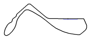
Stardust International Raceway
Former race track
Distance: Approx. 4624 meters
Latitude and longitude: 36.10777778,-115.2525
The Stardust International Raceway was an auto racing track in present-day Spring Valley, Nevada, United States, in the Las Vegas Valley. It featured a flat, 3-mile (4.8 km), 13-turn road course, and a quarter-mile drag strip. Some track maps depicted the road course with 10 numbered turns.
Cowabunga Canyon Waterpark
Water park in Spring Valley, Nevada
Distance: Approx. 4104 meters
Latitude and longitude: 36.059941,-115.300122
Cowabunga Canyon Waterpark is a water park in Spring Valley, Nevada. The park was part of Village Roadshow Theme Parks' Wet'n'Wild chain of water parks located across the world, until it was purchased by Pyek Group in March 2022. Pyek Group also owns Cowabunga Bay and together these 2 water parks makeup the Cowabunga Vegas brand.

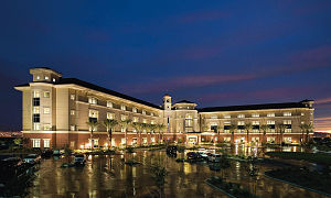
Durango (hotel and casino)
Hotel and casino in Las Vegas, Nevada
Distance: Approx. 2506 meters
Latitude and longitude: 36.063559,-115.282846
Durango is a hotel and casino in Rhodes Ranch, a community in the Las Vegas Valley. It is located along Durango Drive, beside the Las Vegas Beltway. The resort includes an 83,178 sq ft (7,727.5 m2) casino, 209 rooms in a 15-story tower, and several restaurants.

Nevada's 9th Senate district
American legislative district
Distance: Approx. 4616 meters
Latitude and longitude: 36.03,-115.28
Nevada's 9th Senate district is one of 21 districts in the Nevada Senate. It has been represented by Democrat Melanie Scheible since 2018, succeeding Republican Becky Harris.
The Gramercy
Apartments and commercial in Nevada, United States
Distance: Approx. 3984 meters
Latitude and longitude: 36.084095,-115.293612
The Gramercy is a mixed-use development project in Spring Valley, Nevada, west of the Las Vegas Strip. It includes two office buildings and 160 apartment units. Gemstone Development began construction of the project, originally known as ManhattanWest, in 2007.
UFC Apex
Events facility at UFC
Distance: Approx. 2455 meters
Latitude and longitude: 36.068,-115.228
UFC Apex (stylized as UFC APEX) is a live events and production center in Enterprise, Nevada, operated and owned by TKO Group Holdings (TKO). The venue hosts events held by TKO's two divisions, the Ultimate Fighting Championship (UFC) and WWE, as well as events of the Dana White-owned Power Slap league. The facility's location was chosen in part due to its close proximity to the UFC Performance Institute, which serves as the UFC's headquarters and is located across the street.
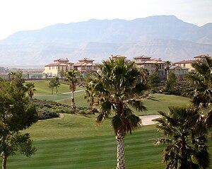
Rhodes Ranch
Planned community and golf course in Nevada, United States
Distance: Approx. 3792 meters
Latitude and longitude: 36.04416667,-115.28722222
Rhodes Ranch is a master-planned community and golf course located in Spring Valley, Nevada, approximately six miles southwest of the Las Vegas Strip. It was developed by Jim Rhodes. The community was announced in 1996, after Rhodes gained 1,330 acres (540 ha), some of it through the Bureau of Land Management.
Weather in this IP's area
smoke
30 Celsius
29 Celsius
29 Celsius
31 Celsius
1006 hPa
24 %
1006 hPa
923 hPa
10000 meters
8.23 m/s
200 degree
40 %
05:44:40
19:50:08