Country:
 USA
USARegion:
City:
Latitude and Longitude:
Time Zone:
Postal Code:
IP information under different IP Channel
ip-api
Country
Region
City
ASN
Time Zone
ISP
Blacklist
Proxy
Latitude
Longitude
Postal
Route
IPinfo
Country
Region
City
ASN
Time Zone
ISP
Blacklist
Proxy
Latitude
Longitude
Postal
Route
MaxMind
Country
Region
City
ASN
Time Zone
ISP
Blacklist
Proxy
Latitude
Longitude
Postal
Route
Luminati
Country
USASN
Time Zone
America/Chicago
ISP
UNITI-FIBER
Latitude
Longitude
Postal
db-ip
Country
Region
City
ASN
Time Zone
ISP
Blacklist
Proxy
Latitude
Longitude
Postal
Route
ipdata
Country
Region
City
ASN
Time Zone
ISP
Blacklist
Proxy
Latitude
Longitude
Postal
Route
Popular places and events near this IP address

Warrington, Florida
CDP in Florida, United States
Distance: Approx. 1809 meters
Latitude and longitude: 30.38583333,-87.28972222
Warrington is a census-designated place (CDP) in Escambia County, Florida, United States. Warrington is located between downtown Pensacola and the state line with Alabama; it is 6 miles (10 km) away from both. The population was 15,218 at the 2020 census, up from 14,531 at the 2010 census.

Center for Information Warfare Training
One of eleven learning centers of U.S. Naval Education and Training Command
Distance: Approx. 3293 meters
Latitude and longitude: 30.4017,-87.29
The United States Navy's Center for Information Warfare Training (CIWT) is one of the learning centers of Naval Education and Training Command, headquartered on Naval Air Station Pensacola Corry Station in Escambia County, Florida. It is responsible for the development of education and training policies for over 26,000 members of the Information Warfare Corps in the fields of cryptology and intelligence, along with the cyber realms of information operations and technology, and computer systems and networks. The center also oversees Language, Regional Expertise and Culture.
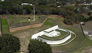
Fort Barrancas
United States historic place
Distance: Approx. 3637 meters
Latitude and longitude: 30.34783889,-87.29756111
Fort Barrancas (1839) or Fort San Carlos de Barrancas (from 1787) is a United States military fort and National Historic Landmark in the former Warrington area of Pensacola, Florida, located physically within Naval Air Station Pensacola, which was developed later around it. The hill-top fort, connected to a sea level water battery, overlooks Pensacola Bay. From 1839 to 1844, the historic Spanish fort on the hill was reconstructed and dramatically expanded in brick.

Siege of Pensacola
1781 battle of the American Revolutionary War
Distance: Approx. 3625 meters
Latitude and longitude: 30.34777778,-87.29722222
The siege of Pensacola, fought from March 9 to May 10, 1781, was the culmination of Spain's conquest of West Florida during the Gulf Coast Campaign of the American Revolutionary War.

Barrancas National Cemetery
Historic veterans cemetery in Escambia County, Florida
Distance: Approx. 2378 meters
Latitude and longitude: 30.3551382,-87.2859486
Barrancas National Cemetery is a United States National Cemetery located at Naval Air Station Pensacola, in the city of Pensacola, Florida. It encompasses 94.9 acres (38.4 ha), and as of 2021 had over 50,000 interments.
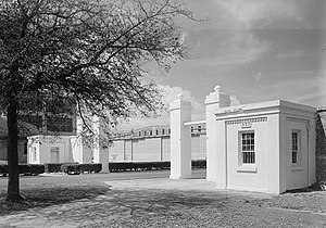
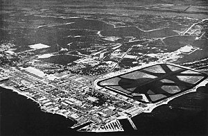
Pensacola Naval Air Station Historic District
Historic district in Florida, United States
Distance: Approx. 3625 meters
Latitude and longitude: 30.34777778,-87.29722222
The Pensacola Naval Air Station Historic District encompasses the early historic elements of Naval Air Station Pensacola in Warrington, Florida. Included in the historic district are surviving buildings of the Pensacola Navy Yard, which the air station took over, as well as buildings related to the early years of aviator training by the United States Navy. The district, roughly bounded by West Street, Saufley Avenue, and Pensacola Bay, was designated a U.S. National Historic Landmark District in 1976.

Capture of Pensacola (1719)
Distance: Approx. 3625 meters
Latitude and longitude: 30.34777778,-87.29722222
The Capture of Pensacola took place in May 1719 during the War of the Quadruple Alliance when a French force led by Jean-Baptiste Le Moyne de Bienville took and occupied the settlement of Pensacola in the Spanish colony of Florida. The French occupied Pensacola until August 1719, when a large Spanish force arrived and compelled the small French garrison to surrender. This Spanish occupation only lasted until September 1, when a French fleet arrived to reassert French control.
Chevalier Field
Distance: Approx. 2469 meters
Latitude and longitude: 30.35361111,-87.26805556
Chevalier Field was the original non-seaplane aircraft landing area at Naval Air Station Pensacola, Florida. Established originally in 1922 as Station Field, it was an expansion of the balloon operating field that opened in 1916. It was located on the northeast side of the Navy shipyard, on the western edge of Pensacola Bay and south of Bayou Grande.

Siege of Pensacola (1707)
Part of Queen Anne's War
Distance: Approx. 3625 meters
Latitude and longitude: 30.34777778,-87.29722222
The siege of Pensacola included two separate attempts in 1707 by English-supported Creek Indians to capture the town and fortress of Pensacola, one of two major settlements (the other was St. Augustine) in Spanish Florida. The attacks, part of Queen Anne's War (the North American theater of the War of the Spanish Succession), resulted in the burning of the town, and caused most of its Indian population to flee, although the fort withstood repeated attacks.

Woolsey, Florida
Former community in Florida, U.S.
Distance: Approx. 2132 meters
Latitude and longitude: 30.3569,-87.2678
Woolsey, Florida, was a small community located on the north side of the Pensacola Navy Yard, the construction of which began in Northwest Florida in April 1826. The town was razed in 1922 to make way for expanded Navy facilities.

Naval Air Station Pensacola Corry Station
Distance: Approx. 3661 meters
Latitude and longitude: 30.405,-87.29083333
Naval Air Station Pensacola Corry Station (NASP Corry Station), Information Warfare Training Command (IWTC), formerly known as Naval Technical Training Center Corry Station in Florida, United States, is a sub-installation of nearby Naval Air Station Pensacola that hosts several of the Navy's Information Warfare Corps training commands. IWTC is the headquarters for its Center for Information Warfare Training and is part of the U.S. Navy's Tenth Fleet.

Naval Air Station Pensacola shooting
Mass shooting at Naval Air Station in Pensacola, Florida
Distance: Approx. 3061 meters
Latitude and longitude: 30.35,-87.29
On the morning of December 6, 2019, a terrorist attack occurred at Naval Air Station Pensacola in Pensacola, Florida. The assailant killed three men and injured eight others. The shooter was killed by Escambia County sheriff deputies after they arrived at the scene.
Weather in this IP's area
few clouds
27 Celsius
31 Celsius
24 Celsius
28 Celsius
1017 hPa
87 %
1017 hPa
1017 hPa
10000 meters
2.06 m/s
180 degree
20 %
06:05:13
19:45:44