Country:
 Myanmar (Burma)
Region:
City:
Latitude and Longitude:
Time Zone:
Postal Code:
IP information under different IP Channel
ip-api
Country
Region
City
ASN
Time Zone
ISP
Blacklist
Proxy
Latitude
Longitude
Postal
Route
IPinfo
Country
Region
City
ASN
Time Zone
ISP
Blacklist
Proxy
Latitude
Longitude
Postal
Route
MaxMind
Country
Region
City
ASN
Time Zone
ISP
Blacklist
Proxy
Latitude
Longitude
Postal
Route
Luminati
Country
MMRegion
18
City
naypyitaw
ASN
Time Zone
Asia/Yangon
ISP
GSL Networks Pty LTD
Latitude
Longitude
Postal
db-ip
Country
Region
City
ASN
Time Zone
ISP
Blacklist
Proxy
Latitude
Longitude
Postal
Route
ipdata
Country
Region
City
ASN
Time Zone
ISP
Blacklist
Proxy
Latitude
Longitude
Postal
Route
Popular places and events near this IP address

Naypyidaw
Capital of Myanmar
Distance: Approx. 1565 meters
Latitude and longitude: 19.7475,96.115
Naypyidaw (officially romanized Nay Pyi Taw and also spelled as Naypyitaw and Nay Pyi Daw) (Burmese: နေပြည်တော်; MLCTS: Nepranytau; pronounced [nèpjìdɔ̀] lit. 'Grand Capital'), is the capital and third-largest city of Myanmar. The city is located at the centre of the Naypyidaw Union Territory. It is unusual among Myanmar's cities in that it is an entirely planned city outside of any state or region.

Central Bank of Myanmar
Central bank in Myanmar
Distance: Approx. 5392 meters
Latitude and longitude: 19.7915,96.1441
The Central Bank of Myanmar (Burmese: မြန်မာနိုင်ငံတော်ဗဟိုဘဏ်; MLCTS: mranma nuingngamtau bahuibhan; IPA: [mjəmà nàinŋàndɔ̀ bəhòʊbàn]; abbreviated CBM) is the central bank of Myanmar (formerly Burma).
Ministry of Education (Myanmar)
Myanmar government agency
Distance: Approx. 6280 meters
Latitude and longitude: 19.800635,96.119792
The Ministry of Education (Burmese: ပညာရေးဝန်ကြီးဌာန, Burmese pronunciation: [pjìɲàjé wʊ̀ɰ̃dʑí tʰàna]; abbreviated MOE) is the Myanmar government agency responsible for education in Myanmar.

National Herbal Park
Distance: Approx. 2336 meters
Latitude and longitude: 19.74951944,96.10793056
The National Herbal Park (Burmese: အမျိုးသား ဆေးဖက်ဝင် အပင်များ ပန်းခြံ) is a 200-acre (0.81 km2) park located near the Naypyidaw-Taungnyo Road in Naypyidaw, Myanmar. Over 20,000 herbal and medicinal plants, representing over 700 species from the various states and divisions of Myanmar, are grown in the park. The herbal park is part of the government's efforts to protect and preserve the herbs from depletion and extinction and to keep alive the country's traditional system of medicines.
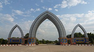
Naypyidaw Water Fountain Garden
Naypyidaw Water Fountain Garden
Distance: Approx. 684 meters
Latitude and longitude: 19.74722222,96.12361111
The Naypyidaw Water Fountain Garden (Burmese: နေပြည်တော် ရေပန်း ဥယျာဉ်) is a garden in Naypyidaw, Myanmar. The 165-acre (67 ha) garden is situated near the Naypyidaw City Hall with a steel structure arch-way. Also included in the garden are a main pond with three fountains and 11 small ponds with 13 different fountains, a 30-foot (9.1 m) high clock tower, nine recreation centres, two small gardens, two stone gardens and ten feet wide buggy road and footpaths.

Uppatasanti Pagoda
Buddhist Pagoda in Naypyidaw, Myanmar
Distance: Approx. 6296 meters
Latitude and longitude: 19.77115,96.18298889
Uppātasanti Pagoda (ဥပ္ပါတသန္တိစေတီတော်, pronounced [ʔoʊʔpàta̰ θàɰ̃dḭ zèdìdɔ̀]; officially called ဥပ္ပါတသန္တိစေတီတော်မြတ်ကြီး, also called the "Peace Pagoda") is a prominent landmark in Naypyidaw, the capital of Myanmar. The pagoda houses a Buddha tooth relic. It is nearly a same-sized replica of Shwedagon Pagoda in Yangon and stands 99 metres (325 ft) tall.

Pyidaungsu Hluttaw
National legislature of Myanmar
Distance: Approx. 4268 meters
Latitude and longitude: 19.77444444,96.10361111
The Pyidaungsu Hluttaw (Burmese: ပြည်ထောင်စု လွှတ်တော် [pjìdàʊɰ̃zṵ l̥ʊʔtɔ̀] lit. Assembly of the Union) is the de jure national-level bicameral legislature of Myanmar (officially known as the Republic of the Union of Myanmar) established by the 2008 National Constitution. The Pyidaungsu Hluttaw is made up of two houses, the 224-seat Amyotha Hluttaw, or "House of Nationalities", and the 440-seat Pyithu Hluttaw, or House of People's Representatives.
Zabuthiri Township
Township in Naypyidaw Union Territory, Myanmar
Distance: Approx. 3271 meters
Latitude and longitude: 19.746,96.0985
Zabuthiri Township (Burmese: ဇမ္ဗူသီရိမြို့နယ်) is one of Naypyidaw Union Territory's eight townships, located south of Mandalay Region in Burma.

Wunna Theikdi Stadium
Myanmar sporting venue
Distance: Approx. 6436 meters
Latitude and longitude: 19.76666667,96.07275
Wunna Theikdi Stadium (Burmese: ဝဏ္ဏသိဒ္ဒိ အားကစားကွင်း) is a multi-use stadium in Naypyidaw, Myanmar. It can seat 30,000 spectators. The stadium hosted the 2013 Southeast Asian Games and 2014 ASEAN Para Games opening and closing ceremonies.

Presidential Palace, Naypyidaw
Official residence of the head of state of Myanmar
Distance: Approx. 2761 meters
Latitude and longitude: 19.7675,96.11861111
The Presidential Palace (Burmese: သမ္မတအိမ်တော်) is the executive office and official residence of the Myanmar head of state and government, the president of Myanmar, and located in the capital city of Nay Pyi Taw. The 100-room palace is a complex of buildings, surrounded by a moat that can be crossed by bridges. Acting President Myint Swe did not move into the Presidential Palace following the 2021 coup d'état.
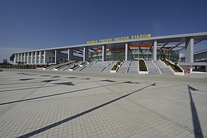
Wunna Theikdi Indoor Stadium
Indoor stadium in Myanmar
Distance: Approx. 7087 meters
Latitude and longitude: 19.77444444,96.06972222
Wunnatheikdi Indoor Stadium(Burmese: ဝဏ္ဏသိဒ္ဓိ မိုးလုံလေလုံအားကစားရုံ) is an indoor stadium located inside Zabuthiri Sports Complex in Naypyidaw. It is composed of Stadium (A), Stadium (B) and Stadium (C). Stadium (A) and (C) have a capacity of 3,000 and Stadium (B) has a capacity of 5,000.
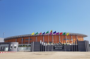
Wunna Theikdi Aquatic Center
Sports venue in Myanmar
Distance: Approx. 6739 meters
Latitude and longitude: 19.77416667,96.07333333
Wunna Theikdi Aquatic Center is an aquatic center located inside Wunna Theikdi Sports Complex in Naypyidaw.It was built to host the 27th SEA Games. Construction began in 2011 and completed in 2013. It features one swimming pool (50 meter), diving pool and outdoor pool.
Weather in this IP's area
overcast clouds
25 Celsius
26 Celsius
25 Celsius
25 Celsius
1003 hPa
95 %
1003 hPa
989 hPa
10000 meters
2.85 m/s
8.12 m/s
161 degree
99 %
05:40:10
18:43:32