Country:
 Laos
LaosRegion:
City:
Latitude and Longitude:
Time Zone:
Postal Code:
IP information under different IP Channel
ip-api
Country
Region
City
ASN
Time Zone
ISP
Blacklist
Proxy
Latitude
Longitude
Postal
Route
IPinfo
Country
Region
City
ASN
Time Zone
ISP
Blacklist
Proxy
Latitude
Longitude
Postal
Route
MaxMind
Country
Region
City
ASN
Time Zone
ISP
Blacklist
Proxy
Latitude
Longitude
Postal
Route
Luminati
Country
LARegion
vt
City
vientiane
ASN
Time Zone
Asia/Vientiane
ISP
GSL Networks Pty LTD
Latitude
Longitude
Postal
db-ip
Country
Region
City
ASN
Time Zone
ISP
Blacklist
Proxy
Latitude
Longitude
Postal
Route
ipdata
Country
Region
City
ASN
Time Zone
ISP
Blacklist
Proxy
Latitude
Longitude
Postal
Route
Popular places and events near this IP address

Kingdom of Laos
1947–1975 constitutional monarchy in Southeast Asia
Distance: Approx. 86 meters
Latitude and longitude: 17.96666667,102.6
The Kingdom of Laos was the form of government in Laos from 1947 to 1975. Located in Southeast Asia at the heart of the Indochinese Peninsula, it was bordered by Burma and China to the northwest, North Vietnam to the east, Cambodia to the southeast, and Thailand to the west and southwest. The country was governed as a constitutional monarchy beginning with its independence on 9 November 1953.

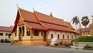
Wat Si Saket
Buddhist wat in Vientiane, Laos
Distance: Approx. 1384 meters
Latitude and longitude: 17.96305556,102.61166667
Wat Si Saket (Lao: ວັດສີສະເກດ, pronounced [wāt sǐː.sā.kèːt]) is a Buddhist wat in Vientiane, Laos. It is situated on Lan Xang Road, on the corner with Setthathirat Road, to the northwest of Haw Phra Kaew, which formerly held the Emerald Buddha.

That Dam
Stupa in Vientiane, Laos
Distance: Approx. 1263 meters
Latitude and longitude: 17.966,102.6111
That Dam (Lao ທາດດຳ [tʰâːt dàm], meaning Black Stupa) is a large stupa located in Vientiane, Laos. The stupa is situated in the middle of the roundabout between Chantha Khoumane road and Bartholonie road. Many Lao people believe it is inhabited by a seven-headed nāga who tried to protect them from an invasion by the Siamese army in 1827.

Lao National Museum
Museum in Vientiane, Laos
Distance: Approx. 850 meters
Latitude and longitude: 17.96694444,102.60722222
The Lao National Museum is a building located in Vientiane, the capital of Laos. The structure was originally built in 1925 as the French governor's residence and today presents the history of the nation, highlighting the Lao people's struggle to free the country from foreign occupation. It is located on Samsenthai road, opposite the cultural hall.

Ministry of Agriculture and Forestry (Laos)
Distance: Approx. 86 meters
Latitude and longitude: 17.96666667,102.6
The Ministry of Agriculture and Forestry of Laos (ກະຊວງ ກະສິກຳ ແລະ ປ່າໄມ້ in Lao language) is a ministry of the government of the Lao People's Democratic Republic (Lao PDR). Its acronym is LMAF. The minister of Agriculture and Forestry is H.E. Sitaheng Rasphone. The ministry plays a role in shaping the Laos agricultural policies, managing its natural resources, and supporting rural development to enhance food security and reduce poverty.
Wat Ong Teu Mahawihan
Buddhist monastery in Vientiane, Laos
Distance: Approx. 505 meters
Latitude and longitude: 17.9656,102.6038
Wat Ong Teu Mahawihan (Temple of the Heavy Buddha) is one of many Buddhist monasteries in the city of Vientiane in Laos. This name is given to the temple due to the large, bronze Phra Ong Teu Buddha image that is in the temple: the largest Buddha in Vientiane. This temple was initially constructed by King Setthathirath I in the 16th century (known as the golden age of Buddhism in Laos) when Laos was being bombarded by the Burmese, but was later demolished during a foreign invasion.
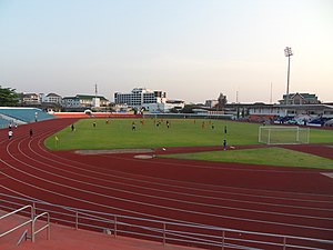
Laos National Stadium
Multi-purpose stadium in Vientiane, Laos
Distance: Approx. 959 meters
Latitude and longitude: 17.96861111,102.60805556
The Laos National Stadium or formally Anouvong Stadium (official name), also known as Vientiane Provincial stadium, is a multi-purpose stadium in Vientiane, Laos. It is named after Chao Anouvong, King of Vientiane. It is used mostly for football matches.

National Library of Laos
Distance: Approx. 973 meters
Latitude and longitude: 17.964,102.6079
The National Library of Laos (Lao language: ຫໍສະໝຸດແຫ່ງຊາດ) is a library located in Vientiane, Laos. First established on 1 July 1956, it moved to its current location in 1988. The National Library plays an important role in preserving materials about Laos.
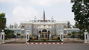
Presidential Palace, Laos
Distance: Approx. 1249 meters
Latitude and longitude: 17.962037,102.60988
The Presidential Palace is the official residence of the President of Laos, who, by convention, also holds the position of General Secretary of the Lao People's Revolutionary Party. It is located on the banks of the Mekong River in the capital city, Vientiane.

Bank of the Lao P.D.R.
Central Bank of Laos
Distance: Approx. 833 meters
Latitude and longitude: 17.9658,102.607
The Bank of the Lao P.D.R. (Lao: ທະນາຄານ ແຫ່ງ ສ. ປ. ປ.

Kualao Restaurant
Restaurant in Vientiane Capital, Laos
Distance: Approx. 1219 meters
Latitude and longitude: 17.9647,102.6105
Kualao Restaurant is a Lao restaurant in Vientiane, the capital city of Laos. It provides upscale Lao cuisine and showcases traditional Lao dance and music performances to its clientele.
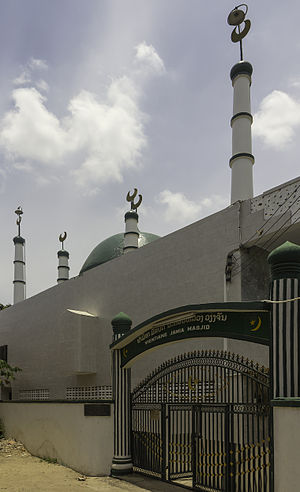
Vientiane Jamia Mosque
Mosque in Vientiane, Laos
Distance: Approx. 1067 meters
Latitude and longitude: 17.96469444,102.60902778
The Vientiane Jamia Mosque, is a mosque in Vientiane, Laos.
Weather in this IP's area
light rain
27 Celsius
29 Celsius
27 Celsius
27 Celsius
1004 hPa
74 %
1004 hPa
985 hPa
7000 meters
2.06 m/s
220 degree
75 %
05:47:02
18:44:54