Country:
 Brazil
Region:
City:
Latitude and Longitude:
Time Zone:
Postal Code:
IP information under different IP Channel
ip-api
Country
Region
City
ASN
Time Zone
ISP
Blacklist
Proxy
Latitude
Longitude
Postal
Route
IPinfo
Country
Region
City
ASN
Time Zone
ISP
Blacklist
Proxy
Latitude
Longitude
Postal
Route
MaxMind
Country
Region
City
ASN
Time Zone
ISP
Blacklist
Proxy
Latitude
Longitude
Postal
Route
Luminati
Country
BRRegion
ba
City
salvador
ASN
Time Zone
America/Bahia
ISP
BR.Digital Provider
Latitude
Longitude
Postal
db-ip
Country
Region
City
ASN
Time Zone
ISP
Blacklist
Proxy
Latitude
Longitude
Postal
Route
ipdata
Country
Region
City
ASN
Time Zone
ISP
Blacklist
Proxy
Latitude
Longitude
Postal
Route
Popular places and events near this IP address
Colonial Brazil
1500–1815 Portuguese possession in South America
Distance: Approx. 20 meters
Latitude and longitude: -12.97083333,-38.51083333
Colonial Brazil (Portuguese: Brasil Colonial) comprises the period from 1500, with the arrival of the Portuguese, until 1815, when Brazil was elevated to a kingdom in union with Portugal. During the 300 years of Brazilian colonial history, the main economic activities of the territory were based first on brazilwood extraction (brazilwood cycle), which gave the territory its name; sugar production (sugar cycle); and finally on gold and diamond mining (gold cycle). Slaves, especially those brought from Africa, provided most of the workforce of the Brazilian export economy after a brief initial period of Indigenous slavery to cut brazilwood.

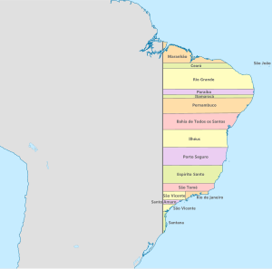
Northeast Region, Brazil
Region in Brazil
Distance: Approx. 790 meters
Latitude and longitude: -12.96666667,-38.51666667
The Northeast Region of Brazil (Portuguese: Região Nordeste do Brasil [ʁeʒiˈɐ̃w nɔʁˈdɛstʃi du bɾaˈziw]) is one of the five official and political regions of the country according to the Brazilian Institute of Geography and Statistics. Of Brazil's twenty-six states, it comprises nine: Maranhão, Piauí, Ceará, Rio Grande do Norte, Paraíba, Pernambuco, Alagoas, Sergipe and Bahia, along with the Fernando de Noronha archipelago (formerly a separate territory, now part of Pernambuco). Chiefly known as Nordeste ("Northeast") in Brazil, this region was the first to be colonized by the Portuguese and other European peoples, playing a crucial role in the country's history.

Cathedral Basilica of Salvador
Distance: Approx. 220 meters
Latitude and longitude: -12.972897,-38.51033
The Cathedral Basilica of Salvador (Catedral Basílica de Salvador), officially dedicated to the Transfiguration of Christ and named Primatial Cathedral Basilica of the Transfiguration of the Lord is the seat of the Archbishop of the city of Salvador, in the State of Bahia, in Brazil. The Archbishop of Salvador is also ex officio Primate of Brazil. The structure was built by the Society of Jesus as part of a large Jesuit monastic and educational complex.

Centro Histórico, Porto Alegre
Neighborhood of Porto Alegre in Rio Grande do Sul, Brazil
Distance: Approx. 790 meters
Latitude and longitude: -12.96666667,-38.51666667
Centro Histórico (English: Historic District) is a neighborhood of the city of Porto Alegre, the state capital of Rio Grande do Sul in Brazil. The neighborhood was created by Law 2022 of December 7, 1959.

Afro-Brazilian Museum
Distance: Approx. 224 meters
Latitude and longitude: -12.9727,-38.5098
The Afro-Brazilian Museum in Salvador, Bahia, Brazil, was inaugurated on 7 January 1982 by the then Director of the Center for Afro-Oriental Studies (CEAO), Dr. Yeda Pessoa de Castro, through an agreement between the Ministries of Foreign Affairs and Education and Culture of Brazil, the government of Bahia, the city of Salvador and the Federal University of Bahia. It is an institution that aims to defend, study and disseminate everything that relates to African-Brazilian themes.

Church of Saint Peter of the Clergymen
Distance: Approx. 269 meters
Latitude and longitude: -12.97292,-38.5094
The Church of Saint Peter of the Clergymen (Portuguese: Igreja de São Pedro dos Clérigos) is an 18th-century Roman Catholic church in Salvador, Bahia, Brazil. It was constructed by the Brotherhood of Saint Peter in approximately 1709 and was renovated in the 18th and 19th centuries. The church was listed as a historic structure by National Institute of Historic and Artistic Heritage (IPHAN) in 1938 and is part of the Historic Center of Salvador UNESCO World Heritage Site.

Sobrado Azulejado
Mansion in Brazil
Distance: Approx. 344 meters
Latitude and longitude: -12.973086,-38.513235
The Sobrado Azulejado, also known as the Sobrado de Azulejos, is a late 19th-century commercial building in Salvador, Bahia, Brazil. It is located in the Comércio district on Praça Cayru, a public square, and close to the Mercado Modelo public market. The house is entirely glazed in azulejo, a tin-glazed ceramic tile; all of the tiles of the sobrado were manufactured in Portugal.

Elevador Lacerda
Building in Bahia, Brazil
Distance: Approx. 440 meters
Latitude and longitude: -12.97416667,-38.51333333
The Lacerda Elevator (Elevador Lacerda) is a public urban elevator located in Salvador, Brazil, connecting the lower city (Cidade Baixa) to the upper city (Cidade Alta). The 72 metres (236 ft) elevator was built between 1869 and 1873; it was named after Antônio de Lacerda, director of the Commercial Association of Bahia. It was a hydraulic elevator at first; later operating by electricity since 1906.

Terreiro de Jesus
Plaza in Salvador, Brazil
Distance: Approx. 260 meters
Latitude and longitude: -12.97312,-38.50989
The Terreiro de Jesus is a plaza located in the Historic Center of Salvador de Bahia in Brazil. The square is located in the oldest part of the city and abuts the Praça da Sé. The Cathedral Basilica of Salvador, formerly the school and church of the Jesuits, is the most prominent structure in the Terreiro de Jesus, and occupies the west of the square.

Church of Saint Michael (Salvador)
Distance: Approx. 486 meters
Latitude and longitude: -12.97414,-38.50779
The Church of Saint Michael (Portuguese: Igreja de São Miguel), formerly known as the Capela do Senhor Bom Jesus da Via Sacra e São Miguel, is an 18th-century Roman Catholic church and former convent in Salvador, Bahia, Brazil. The church is dedicated, as evidenced by its original name, to Our Lord Jesus Crucified of the Via Sacra and Saint Michael the Archange. The church was donated to the Third Order of Saint Francis in 1744.
House at Praça Rio Branco No. 35
Historical colonial house in Brazil
Distance: Approx. 342 meters
Latitude and longitude: -12.9731,-38.5132
The House at Praça Rio Branco No. 35 (Portuguese: Casa à Praça Rio Branco, nº 35) is a sobrado, or Portuguese Colonial multi-story house, in Estância, Sergipe, Brazil. It house the Clube Republicano (Republican Club), the first organization of this size in the Province of Sergipe Del Rey.
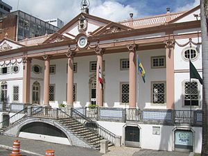
Palace of the Commercial Association of Bahia
Historical building in Brazil
Distance: Approx. 81 meters
Latitude and longitude: -12.97027778,-38.51083333
The Palace of the Commercial Association of Bahia (Portuguese: Palácio da Associação Comercial da Bahia) is a building that houses the headquarters of the Commercial Association of Bahia (ACB), which had its inauguration on January 28, 1817. It is located in the Comércio neighborhood in the municipality of Salvador, capital of the state of Bahia in Brazil. Currently, the palace, which used to house public and private activities, does not provide any services other than those of the ACB itself.
Weather in this IP's area
scattered clouds
26 Celsius
26 Celsius
26 Celsius
26 Celsius
1019 hPa
75 %
1019 hPa
1017 hPa
10000 meters
5.46 m/s
5.93 m/s
113 degree
35 %
05:54:51
17:25:59