Country:
 Brazil
Region:
City:
Latitude and Longitude:
Time Zone:
Postal Code:
IP information under different IP Channel
ip-api
Country
Region
City
ASN
Time Zone
ISP
Blacklist
Proxy
Latitude
Longitude
Postal
Route
IPinfo
Country
Region
City
ASN
Time Zone
ISP
Blacklist
Proxy
Latitude
Longitude
Postal
Route
MaxMind
Country
Region
City
ASN
Time Zone
ISP
Blacklist
Proxy
Latitude
Longitude
Postal
Route
Luminati
Country
BRRegion
ba
City
salvador
ASN
Time Zone
America/Bahia
ISP
BR.Digital Provider
Latitude
Longitude
Postal
db-ip
Country
Region
City
ASN
Time Zone
ISP
Blacklist
Proxy
Latitude
Longitude
Postal
Route
ipdata
Country
Region
City
ASN
Time Zone
ISP
Blacklist
Proxy
Latitude
Longitude
Postal
Route
Popular places and events near this IP address
Londrina
Municipality in Paraná, Brazil
Distance: Approx. 33 meters
Latitude and longitude: -23.31,-51.16277778
Londrina (Portuguese pronunciation: [lõˈdɾĩnɐ], literally "Little London") is a city located in the north of the state of Paraná, South Region, Brazil, and is 369 km (229 miles) away from the state capital, Curitiba. It is the second largest city in the state and fourth largest in the southern region of the country, with 555,965 inhabitants in the city proper (2022). Londrina was originally explored by British settlers, and then officially established in 1930 by a small group of Italian, Japanese and German settlers.

Estádio do Café
Distance: Approx. 3134 meters
Latitude and longitude: -23.28222222,-51.165
The Estádio Jacy Scaff, usually known as Estádio do Café, is a football stadium inaugurated on August 22, 1976, in Londrina, Paraná, with a maximum capacity of 30,000 people. The stadium is owned by the City Hall of Londrina, and is the home ground of Londrina Esporte Clube and Associação Portuguesa Londrinense. Sociedade Esportiva Matsubara also plays at the stadium.
Ginásio do Moringão
Distance: Approx. 1209 meters
Latitude and longitude: -23.32111111,-51.16388889
Ginásio do Moringão is an indoor sporting arena located in Londrina, Brazil. It is used mainly for basketball and volleyball. The capacity of the arena is 8,000 people and it was built in 1972.
State University of Londrina
Public university in Londrina, Brazil
Distance: Approx. 4152 meters
Latitude and longitude: -23.32531,-51.19998
The State University of Londrina (Portuguese: Universidade Estadual de Londrina, UEL) is a public higher education institution located in the city of Londrina, in the state of Paraná, Brazil. It is one of the largest state universities in Brazil, with students from all over the country.
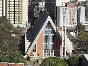
Roman Catholic Archdiocese of Londrina
Latin Catholic territory in Brazil
Distance: Approx. 375 meters
Latitude and longitude: -23.3121,-51.1597
The Archdiocese of Londrina (Latin: Archidioecesis Londrinensis) is a Latin Church ecclesiastical jurisdiction or archdiocese of the Catholic Church in Paraná state, southern Brazil. Its cathedral is Catedral Metropolitana Sagrado Coração de Jesus, dedicated to the Sacred Heart of Jesus, in the archiepiscopal see of Londrina.
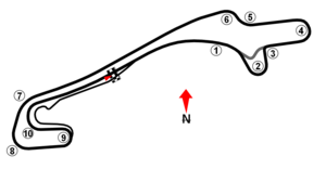
Autódromo Internacional Ayrton Senna (Londrina)
Distance: Approx. 3158 meters
Latitude and longitude: -23.28222222,-51.16722222
Autódromo Internacional Ayrton Senna is a 3.145 km (1.954 mi) motorsports circuit located in Londrina, Brazil. Opened in 1992, it hosts motor racing events for the Formula Three Sudamericana and Formula Renault series.
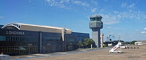
Londrina Airport
Airport serving Londrina in state of Paraná, Brazil
Distance: Approx. 3476 meters
Latitude and longitude: -23.33027778,-51.13666667
Londrina–Gov. José Richa Airport (IATA: LDB, ICAO: SBLO) is the airport serving Londrina, Brazil. It is named after José Richa (1934–2003), former Mayor of Londrina and Governor of Paraná.
Sacred Heart of Jesus Cathedral, Londrina
Church in Londrina, Brazil
Distance: Approx. 381 meters
Latitude and longitude: -23.3122,-51.1597
The Sacred Heart of Jesus Cathedral (Portuguese: Catedral Metropolitana Sagrado Coração de Jesus) or Londrina Cathedral is a religious building belonging to the Catholic Church in the center of the city of Londrina, in northern Paraná state in the South American country of Brazil. Built in wood, at the highest point of the earth used to house the city of Londrina, the second church of the city was built based on the designs of engineer Willie Davids, which was inaugurated on August 19, 1934. In 1937, designed a project in neogothic style by the engineer Fristch.
Weather in this IP's area
clear sky
25 Celsius
24 Celsius
25 Celsius
25 Celsius
1020 hPa
35 %
1020 hPa
954 hPa
10000 meters
2.95 m/s
4.03 m/s
53 degree
1 %
07:01:00
18:01:03