Country:
 Brazil
Region:
City:
Latitude and Longitude:
Time Zone:
Postal Code:
IP information under different IP Channel
ip-api
Country
IPinfo
Country
MaxMind
Country
Luminati
Country
BRRegion
mg
City
belohorizonte
ASN
Time Zone
America/Sao_Paulo
ISP
AMERICAN TOWER DO BRASIL-COMUNICACAO MULTIMIDIA LT
Latitude
Longitude
Postal
db-ip
Country
ipdata
Country
Popular places and events near this IP address

Belo Horizonte
Capital city of Minas Gerais, Brazil
Distance: Approx. 641 meters
Latitude and longitude: -19.91666667,-43.93333333
Belo Horizonte is the sixth-largest city in Brazil, with a population of around 2.3 million, and the third largest metropolitan area, with a population of 6 million. It is the 13th-largest city in South America and the 18th-largest in the Americas. The metropolis is anchor to the Belo Horizonte metropolitan area, ranked as the third most populous metropolitan area in Brazil and the 17th most populous in the Americas.
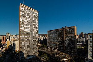
Conjunto Governador Kubitschek
Building in Belo Horizonte, Brazil
Distance: Approx. 922 meters
Latitude and longitude: -19.92388889,-43.94583333
The JK Building is the tallest building in downtown Belo Horizonte, Brazil, named for Juscelino Kubitschek, who was the mayor of Belo Horizonte and later president of Brazil. Standing at 40 stories tall, the JK Building is the third tallest building in Brazil after the Itália Building (45 stories) and Mirante do Vale (51 stories), both in São Paulo. It was designed by Oscar Niemeyer in 1951, to work like a complete town.

Faculdade de Direito e Ciências do Estado da Universidade Federal de Minas Gerais
Distance: Approx. 563 meters
Latitude and longitude: -19.925667,-43.936686
Faculdade de Direito e Ciências do Estado da Universidade Federal de Minas Gerais (Faculty of Law and State Sciences of the Federal University of Minas Gerais) is the university's oldest unit, and even appeared before UFMG. Recognized internationally, it is considered a center of excellence in legal education, professional training with great ability and critical view. The qualification of teachers - most have the title of doctor - and the high level of students ensure the recognition of its progress.

Praça Raul Soares
Distance: Approx. 809 meters
Latitude and longitude: -19.92274167,-43.94511389
The Praça Raul Soares (English: Raul Soares Square) is a major square of Belo Horizonte, Brazil. The square is named in honor of Raul Soares de Moura, former governor of Minas Gerais. It is situated at the confluence of four major avenues: Amazonas, Augusto de Lima, Bias Fortes and Olegário Maciel.

Praça Rui Barbosa
Public square in Belo Horizonte
Distance: Approx. 585 meters
Latitude and longitude: -19.91679167,-43.93396667
The Praça Rui Barbosa (English: Rui Barbosa Square), also called Praça da Estação (Station Square), is a square in Belo Horizonte, Brazil. It has this name due to its proximity to Belo Horizonte's Central Station. The square has the first public clock in the city.

Ribeirão Arrudas
Distance: Approx. 735 meters
Latitude and longitude: -19.91416667,-43.93666667
Arrudas is a stream that begins its course in Contagem and goes down through Belo Horizonte in the Brazilian state of Minas Gerais. It is one of the source of Das Velhas River Rio das Velhas in Sabará. Ribeirão Arrudas is formed by many streams: Jatobá, Barreiro, Bonsucesso, Cercadinho, Piteiras, Leitão, Acaba Mundo, Serra, Taquaril, Navio-baleia, Santa Terezinha, Ferrugem, Tijuco, Pastinho, among others, which are the tributaries of Arrudas.

Praça Sete de Setembro
Public square in Belo Horizonte
Distance: Approx. 202 meters
Latitude and longitude: -19.91912222,-43.93866111
The Praça Sete de Setembro (English: 7 September Square), often called Praça Sete, is a square in downtown Belo Horizonte, Minas Gerais, Brazil. It is located at the intersection of two major avenues, Afonso Pena and Amazonas, and by the streets Rio de Janeiro and Carijós. It boasts an obelisk at its center donated by the people of the neighboring Capela Nova do Betim, today the city of Betim, the inhabitants of the state capital, on the occasion of the commemoration of the centenary of the Independence of Brazil, on 7 September 1822.

Greater Belo Horizonte
Place in Minas Gerais, Brazil
Distance: Approx. 641 meters
Latitude and longitude: -19.91666667,-43.93333333
Greater Belo Horizonte, Brazil, is the name usually used to describe the Belo Horizonte metropolitan region, which is composed of 34 municipalities. As of 2013, it is the third largest metropolitan area of Brazil with more than Six million inhabitants; the largest city by population is Belo Horizonte.

Basilica of Our Lady of Lourdes, Belo Horizonte
Church in Belo Horizonte, Brazil
Distance: Approx. 888 meters
Latitude and longitude: -19.9286,-43.9389
The Basilica of Our Lady of Lourdes (Portuguese: Basílica de Nossa Senhora de Lourdes), also known as the Basilica of Belo Horizonte, is a Catholic church built in a predominantly neo-Gothic style, which is located in Belo Horizonte, Brazil. Its construction was completed around 1923. The author of the project was Manoel Tunes, and the works were made by Antonio Gonçalves Gravatá.

Lagoinha station
Belo Horizonte metro station
Distance: Approx. 999 meters
Latitude and longitude: -19.91297222,-43.94255556
Lagoinha is a Belo Horizonte Metro station on Line 1. It was opened on 1 August 1986 as the eastern terminus of the inaugural section of the line, from Eldorado to Lagoinha. In April 1987, the line was extended to Central.

Central station (Belo Horizonte Metro)
Belo Horizonte metro station
Distance: Approx. 583 meters
Latitude and longitude: -19.91758333,-43.93322222
Central is a Belo Horizonte Metro station on Line 1. It was opened in April 1987 as a one-station extension of the line from Lagoinha. In April 1992 the line was extended to Santa Efigênia.

São José Church
Catholic church in Belo Horizonte, Brazil
Distance: Approx. 106 meters
Latitude and longitude: -19.92111111,-43.93861111
The São José church is an eclectic-style church with Neo-Gothic influence located in downtown Belo Horizonte, Minas Gerais, Brazil. It was built by the Redemptorist congregation.
Weather in this IP's area
clear sky
23 Celsius
23 Celsius
23 Celsius
24 Celsius
1017 hPa
29 %
1017 hPa
921 hPa
10000 meters
1.54 m/s
80 degree
06:31:04
17:30:52