Country:
 Brazil
Region:
City:
Latitude and Longitude:
Time Zone:
Postal Code:
IP information under different IP Channel
ip-api
Country
Region
City
ASN
Time Zone
ISP
Blacklist
Proxy
Latitude
Longitude
Postal
Route
IPinfo
Country
Region
City
ASN
Time Zone
ISP
Blacklist
Proxy
Latitude
Longitude
Postal
Route
MaxMind
Country
Region
City
ASN
Time Zone
ISP
Blacklist
Proxy
Latitude
Longitude
Postal
Route
Luminati
Country
BRRegion
mg
City
belohorizonte
ASN
Time Zone
America/Sao_Paulo
ISP
AMERICAN TOWER DO BRASIL-COMUNICACAO MULTIMIDIA LT
Latitude
Longitude
Postal
db-ip
Country
Region
City
ASN
Time Zone
ISP
Blacklist
Proxy
Latitude
Longitude
Postal
Route
ipdata
Country
Region
City
ASN
Time Zone
ISP
Blacklist
Proxy
Latitude
Longitude
Postal
Route
Popular places and events near this IP address
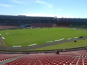
Estádio Parque do Sabiá
Distance: Approx. 4808 meters
Latitude and longitude: -18.91388889,-48.2325
The Estádio Municipal Parque do Sabiá, also known as Parque do Sabiá ("Thrush Park"), is a multi-use stadium in Uberlândia, Brazil. It is currently used mostly for football matches. It is the home ground of Uberlândia Esporte Clube and Clube Atlético Portal, and is the biggest stadium in Minas Gerais state countryside.

Federal University of Uberlândia
Distance: Approx. 2119 meters
Latitude and longitude: -18.91861111,-48.25777778
The Federal University of Uberlândia (Portuguese: Universidade Federal de Uberlândia, UFU) is a Brazilian public university, located in the southwest of Minas Gerais, in Uberlândia, Brazil. The students are admitted through both annual exams, the vestibular, and the National High School Exam. As of 2014, UFU offers 55 undergraduate degrees, including a sought-after Medicine degree, Law, Economics, plus Engineering, Business, Science and Art degrees.
Carmo do Paranaíba
Town and municipality in Minas Gerais, Brazil
Distance: Approx. 9998 meters
Latitude and longitude: -19.00083333,-48.31583333
Carmo do Paranaíba is a Brazilian municipality located in the northwest of the state of Minas Gerais. Its population as of 2020 was 30,334 people living in a total area of 1,307 km2 (505 sq mi). The city belongs to the mesoregion of Triângulo Mineiro e Alto Paranaiba and to the microregion of Patos de Minas.
Uberlândia Airport
Airport in Brazil
Distance: Approx. 6767 meters
Latitude and longitude: -18.88361111,-48.22527778
Uberlândia–Tenente Coronel Aviador César Bombonato Airport (IATA: UDI, ICAO: SBUL) is the airport serving Uberlândia, Brazil. Since June 7, 2001 the airport has been named after the Uberlândia-born pilot of the Brazilian Air Force César Bombonato (1955–1998), who died in an air crash.
Weather in this IP's area
clear sky
23 Celsius
22 Celsius
23 Celsius
23 Celsius
1019 hPa
43 %
1019 hPa
923 hPa
10000 meters
3.09 m/s
60 degree
06:43:00
17:56:00