Country:
 Brazil
Region:
City:
Latitude and Longitude:
Time Zone:
Postal Code:
IP information under different IP Channel
ip-api
Country
Region
City
ASN
Time Zone
ISP
Blacklist
Proxy
Latitude
Longitude
Postal
Route
IPinfo
Country
Region
City
ASN
Time Zone
ISP
Blacklist
Proxy
Latitude
Longitude
Postal
Route
MaxMind
Country
Region
City
ASN
Time Zone
ISP
Blacklist
Proxy
Latitude
Longitude
Postal
Route
Luminati
Country
BRRegion
mg
City
belohorizonte
ASN
Time Zone
America/Sao_Paulo
ISP
AMERICAN TOWER DO BRASIL-COMUNICACAO MULTIMIDIA LT
Latitude
Longitude
Postal
db-ip
Country
Region
City
ASN
Time Zone
ISP
Blacklist
Proxy
Latitude
Longitude
Postal
Route
ipdata
Country
Region
City
ASN
Time Zone
ISP
Blacklist
Proxy
Latitude
Longitude
Postal
Route
Popular places and events near this IP address
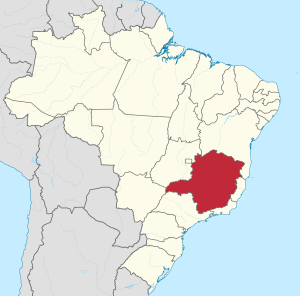
Minas Gerais
State in Brazil
Distance: Approx. 628 meters
Latitude and longitude: -19.81666667,-43.95
Minas Gerais (Portuguese: [ˈminɐz ʒeˈɾajs] ) is one of the 27 federative units of Brazil, being the fourth largest state by area and the second largest in number of inhabitants with a population of 20,539,989 according to the 2022 census. Located in the Southeast Region of the country, it is limited to south and southwest with São Paulo; Mato Grosso do Sul to the west; Goiás and the Federal District to the northwest; Bahia to the north and northeast; Espírito Santo to the east; and Rio de Janeiro to the southeast. The state's capital and largest city, Belo Horizonte, is a major urban and finance center in Brazil, being the sixth most populous municipality in the country while its metropolitan area ranks as the third largest in Brazil with just over 5.8 million inhabitants, after those of São Paulo and Rio de Janeiro.

Carlos Drummond de Andrade Airport
Airport in Minas Gerais, Brazil
Distance: Approx. 3965 meters
Latitude and longitude: -19.85194444,-43.95055556
Pampulha–Carlos Drummond de Andrade Airport (IATA: PLU, ICAO: SBBH) is an airport serving Belo Horizonte, Brazil, located in the neighborhood of Pampulha. Since December 16, 2004, the airport is also named after the Minas Gerais-born poet Carlos Drummond de Andrade (1902–1987).

Jesuit School of Philosophy and Theology
Distance: Approx. 2464 meters
Latitude and longitude: -19.83856111,-43.95232778
The Jesuit School of Philosophy and Theology (FAJE) is a private Jesuit college located in Belo Horizonte, Brazil. It offers undergraduate and graduate courses in philosophy and theology. According to the General Course Index for the three-year period from 2009 to 2011, FAJE was considered the fifth best private college of higher education in Brazil, receiving a 5 on a scale from 1 to 5.

Metropolitana de Belo Horizonte (mesoregion)
Mesoregion in Southeast, Brazil
Distance: Approx. 32 meters
Latitude and longitude: -19.81694444,-43.95583333
The mesoregion Metropolitana de Belo Horizonte is one of the twelve mesoregions of the Brazilian state of Minas Gerais. It is composed of 105 municipalities, distributed across 8 microregions. It is the most populous and densely populated of all the mesoregions of Minas Gerais.
Vila Olímpica
Association football training ground in Belo Horizonte, Brazil
Distance: Approx. 1319 meters
Latitude and longitude: -19.82833333,-43.95361111
Vila Olímpica (Olympic Village) is Atlético Mineiro's former training ground, located in Belo Horizonte, Brazil. Inaugurated in 1973, it served as the club's main training facility for almost three decades, before Cidade do Galo was built. It also hosted the Brazil national football team in its preparation for the 1982 FIFA World Cup.

Pampulha Modern Ensemble
UNESCO World Heritage Site in Minas Gerais, Brazil
Distance: Approx. 4335 meters
Latitude and longitude: -19.851944,-43.973611
The Pampulha Modern Ensemble (Portuguese: Conjunto Moderno da Pampulha) is an urban project in Belo Horizonte, Minas Gerais, Brazil. It was designed around an artificial lake, Lake Pampulha, in the district of Pampulha and includes a casino, a ballroom, the Golf Yacht Club (currently Iate Tênis Clube) and the Church of Saint Francis of Assisi. The buildings were designed by the architect Oscar Niemeyer, in collaboration with the landscape architect Roberto Burle Marx, Brazilian Modernist artists, and engineer Joaquim Cardozo.

Christ the King Cathedral, Belo Horizonte
Church in Belo Horizonte, Brazil
Distance: Approx. 1161 meters
Latitude and longitude: -19.8203,-43.9456
The Christ the King Cathedral, (Portuguese: Catedral Cristo Rei) also known as the Belo Horizonte Cathedral, is a Catholic religious cathedral, currently under construction, located in Belo Horizonte, Minas Gerais, in Brazil. The building is the latest project of the renowned architect Oscar Niemeyer for the city and will be the headquarters of the Archdiocese of Belo Horizonte. The cathedral is dedicated to Christ the King, according to the election of Bishop Antonio dos Santos Cabral, who arrived in Belo Horizonte in 1922 to install the diocese of the capital.
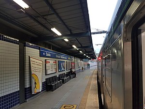
Waldomiro Lobo station
Belo Horizonte metro station
Distance: Approx. 4238 meters
Latitude and longitude: -19.84780556,-43.93266667
Waldomiro Lobo is a Belo Horizonte Metro station on Line 1. It was opened in July 2002 as part of a two-station extension of the line from Primeiro de Maio to Floramar. The station is located between Primeiro de Maio and Floramar.

Floramar station
Belo Horizonte metro station
Distance: Approx. 2538 meters
Latitude and longitude: -19.83416667,-43.94041667
Floramar is a Belo Horizonte Metro station on Line 1. It was opened in July 2002 as the northern terminus of the two-station extension of the line from Primeiro de Maio to Floramar. On 20 September 2002, the line was extended to Vilarinho.
Vilarinho station
Belo Horizonte metro station
Distance: Approx. 1035 meters
Latitude and longitude: -19.82161111,-43.94761111
Vilarinho is a Belo Horizonte Metro station on Line 1 which serves as the north terminus of the line. It was opened 20 September 2002 as a one-station extension of the line from Floramar. The adjacent station is Floramar.

Iate Tênis Clube
Distance: Approx. 4269 meters
Latitude and longitude: -19.848365,-43.978992
The Iate Tênis Clube (English: Yacht Tennis Club) is a recreational club located on the shore of the Lake Pampulha in Belo Horizonte. Its building was designed by architect Oscar Niemeyer in the early 1940s, integrating the Pampulha Architectural Complex, recognized by UNESCO as a World Heritage Site since 2016.

Pampulha Art Museum
Museum in Belo Horizonte, Brazil
Distance: Approx. 4329 meters
Latitude and longitude: -19.851833,-43.973722
The Pampulha Art Museum (Portuguese: Museu de Arte da Pampulha), formerly known as Cassino da Pampulha, is a building that is part of the Pampulha Modern Ensemble located in Belo Horizonte, Minas Gerais, Brazil. The building was designed by the architect Oscar Niemeyer at the request of the then-mayor of the city, Juscelino Kubitschek, and is recognized by UNESCO as a World Heritage Site along with the rest of the ensemble since 2016.
Weather in this IP's area
clear sky
26 Celsius
26 Celsius
25 Celsius
26 Celsius
1018 hPa
42 %
1018 hPa
934 hPa
10000 meters
1.79 m/s
1.79 m/s
44 degree
5 %
06:27:06
17:37:19