Country:
 Brazil
Region:
City:
Latitude and Longitude:
Time Zone:
Postal Code:
IP information under different IP Channel
ip-api
Country
Region
City
ASN
Time Zone
ISP
Blacklist
Proxy
Latitude
Longitude
Postal
Route
IPinfo
Country
Region
City
ASN
Time Zone
ISP
Blacklist
Proxy
Latitude
Longitude
Postal
Route
MaxMind
Country
Region
City
ASN
Time Zone
ISP
Blacklist
Proxy
Latitude
Longitude
Postal
Route
Luminati
Country
BRRegion
mg
City
alfredovasconcelos
ASN
Time Zone
America/Sao_Paulo
ISP
AMERICAN TOWER DO BRASIL-COMUNICACAO MULTIMIDIA LT
Latitude
Longitude
Postal
db-ip
Country
Region
City
ASN
Time Zone
ISP
Blacklist
Proxy
Latitude
Longitude
Postal
Route
ipdata
Country
Region
City
ASN
Time Zone
ISP
Blacklist
Proxy
Latitude
Longitude
Postal
Route
Popular places and events near this IP address
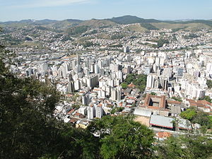
Juiz de Fora
Municipality in Southeast, Brazil
Distance: Approx. 270 meters
Latitude and longitude: -21.76194444,-43.34944444
Juiz de Fora (Portuguese pronunciation: [ˈʒwiz dʒi ˈfɔɾɐ], Outsider Judge), also known as J.F., is a city in the southeastern Brazilian state of Minas Gerais, approximately 40 kilometres (25 mi) from the state border with Rio de Janeiro. According to the 2022 census the current population is 540,756 inhabitants. The geographical area of the municipality is 1,437 km2 (555 sq mi).

Federal University of Juiz de Fora
Public university in Minas Gerais, Brazil
Distance: Approx. 2193 meters
Latitude and longitude: -21.77472222,-43.36833333
The Federal University of Juiz de Fora (Portuguese: Universidade Federal de Juiz de Fora, UFJF) is a public research university in Brazil. Throughout its over 50 years of existence, the university has undergone significant growth, strengthening the quality of undergraduate and graduate education while maintaining its role as an agent of community development.
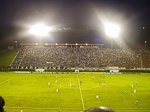
Estádio Mário Helênio
Distance: Approx. 3860 meters
Latitude and longitude: -21.7875,-43.37805556
Estádio Municipal Radialista Mário Helênio, also known as Estádio Mário Helênio, and as Estádio Municipal de Juiz de Fora, is a multi-use stadium in Juiz de Fora, Brazil. It is currently used mostly for football matches. The stadium has a maximum capacity of 31,863 people.

Mariano Procópio Museum
Distance: Approx. 2233 meters
Latitude and longitude: -21.7461,-43.3597
The Mariano Procópio Museum (Portuguese: Museu Mariano Procópio) is a museum of art, history and the natural sciences located in Juiz de Fora, Minas Gerais, Brazil. Founded in 1915 by Alfredo Ferreira Lage, it was the first museum ever built in Minas Gerais, and the third museum ever built in Brazil. The museum contains approximately 45,000 specimens.

Roman Catholic Archdiocese of Juiz de Fora
Catholic ecclesiastical territory
Distance: Approx. 70 meters
Latitude and longitude: -21.7639,-43.3498
The Roman Catholic Archdiocese of Juiz de Fora (Latin: Archidioecesis Iudiciforensis) is an archdiocese located in the city of Juiz de Fora in Brazil.
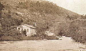
Marmelos Zero Power Plant
Dam in Juiz de Fora, Minas Gerais
Distance: Approx. 5017 meters
Latitude and longitude: -21.78666667,-43.30833333
The Marmelos Zero Power Plant is a decommissioned hydroelectric power plant on the Paraibuna River in Juiz de Fora, Minas Gerais, Brazil. Inaugurated in 1889, plant was the first major hydroelectric power plant constructed in South America, specifically for public use. It was purchased by CEMIG in 1980 and now serves as a museum.

Juiz de Fora Airport
Airport
Distance: Approx. 4850 meters
Latitude and longitude: -21.79305556,-43.38555556
Francisco Álvares de Assis Airport (IATA: JDF, ICAO: SBJF), also called Serrinha Airport, is an airport in Juiz de Fora, Brazil. Since December 29, 1952, the airport is named after the entrepreneur Francisco Álvares de Assis. It is managed by contract by Infraero.
Jesuit College, Juiz de Fora
Private school in Minas Gerais, Brazil
Distance: Approx. 458 meters
Latitude and longitude: -21.76830556,-43.35071944
Jesuit College is a private Catholic primary and secondary school in Juiz de Fora, Minas Gerais, Brazil. It was founded by the Society of Jesus in 1956 and occupies 20 acres (8.1 ha) of forested land in the center of the city. In 2015 the college was rated 51st nationally in Brazil among those schools that took the National Secondary Education Examination (Enem).
Weather in this IP's area
overcast clouds
18 Celsius
17 Celsius
18 Celsius
18 Celsius
1021 hPa
58 %
1021 hPa
941 hPa
10000 meters
1.27 m/s
1.45 m/s
44 degree
85 %
06:27:44
17:31:50