Country:
 Brazil
Region:
City:
Latitude and Longitude:
Time Zone:
Postal Code:
IP information under different IP Channel
ip-api
Country
Region
City
ASN
Time Zone
ISP
Blacklist
Proxy
Latitude
Longitude
Postal
Route
IPinfo
Country
Region
City
ASN
Time Zone
ISP
Blacklist
Proxy
Latitude
Longitude
Postal
Route
MaxMind
Country
Region
City
ASN
Time Zone
ISP
Blacklist
Proxy
Latitude
Longitude
Postal
Route
Luminati
Country
BRRegion
mg
City
montesclaros
ASN
Time Zone
America/Sao_Paulo
ISP
AMERICAN TOWER DO BRASIL-COMUNICACAO MULTIMIDIA LT
Latitude
Longitude
Postal
db-ip
Country
Region
City
ASN
Time Zone
ISP
Blacklist
Proxy
Latitude
Longitude
Postal
Route
ipdata
Country
Region
City
ASN
Time Zone
ISP
Blacklist
Proxy
Latitude
Longitude
Postal
Route
Popular places and events near this IP address
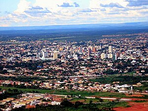
Montes Claros
Municipality in Southeast, Brazil
Distance: Approx. 566 meters
Latitude and longitude: -16.73055556,-43.86388889
Montes Claros is a city located in northern Minas Gerais state, in Brazil. It is located north of the state capital, about 422 km away from it. The population is 413,487 (2020 est.) in an area of 3,569 km2 (1,378 sq mi).

Roman Catholic Archdiocese of Montes Claros
Catholic ecclesiastical territory
Distance: Approx. 1106 meters
Latitude and longitude: -16.7253,-43.8632
The Roman Catholic Archdiocese of Montes Claros (Latin: Archidioecesis Montisclarensis) is a Latin Rite Metropolitan archdiocese in Minas Gerais, Brazil. Its cathedral archiepiscopal see is the Catedral Metropolitana Nossa Senhora Aparecida, dedicated to Our Lady of Aparecida, in the city of Montes Claros.

Montes Claros Airport
Airport
Distance: Approx. 5310 meters
Latitude and longitude: -16.70611111,-43.82194444
Montes Claros–Mário Ribeiro Airport (IATA: MOC, ICAO: SBMK) is the airport serving the city of Montes Claros, Brazil. Since April 2, 2003, the airport is named after Mário Ribeiro (1924–1999), a local politician.

Norte de Minas (mesoregion)
Mesoregion in Southeast, Brazil
Distance: Approx. 49 meters
Latitude and longitude: -16.735,-43.86194444
Norte de Minas (English: Northern Minas) is one of the twelve mesoregions of the Brazilian state of Minas Gerais. It is composed of 89 municipalities, distributed across 7 microregions.
Weather in this IP's area
clear sky
19 Celsius
19 Celsius
19 Celsius
19 Celsius
1020 hPa
55 %
1020 hPa
943 hPa
10000 meters
0.23 m/s
0.78 m/s
6 degree
06:22:02
17:41:38