Country:
 Brazil
Region:
City:
Latitude and Longitude:
Time Zone:
Postal Code:
IP information under different IP Channel
ip-api
Country
Region
City
ASN
Time Zone
ISP
Blacklist
Proxy
Latitude
Longitude
Postal
Route
IPinfo
Country
Region
City
ASN
Time Zone
ISP
Blacklist
Proxy
Latitude
Longitude
Postal
Route
MaxMind
Country
Region
City
ASN
Time Zone
ISP
Blacklist
Proxy
Latitude
Longitude
Postal
Route
Luminati
Country
BRRegion
mg
City
contagem
ASN
Time Zone
America/Sao_Paulo
ISP
AMERICAN TOWER DO BRASIL-COMUNICACAO MULTIMIDIA LT
Latitude
Longitude
Postal
db-ip
Country
Region
City
ASN
Time Zone
ISP
Blacklist
Proxy
Latitude
Longitude
Postal
Route
ipdata
Country
Region
City
ASN
Time Zone
ISP
Blacklist
Proxy
Latitude
Longitude
Postal
Route
Popular places and events near this IP address

Poços de Caldas
Municipality in Minas Gerais, Brazil
Distance: Approx. 59 meters
Latitude and longitude: -21.78777778,-46.56083333
Poços de Caldas is a municipality in the south of Minas Gerais state, Brazil, in the microregion of the same name. Its estimated population in 2020 was 168,641 inhabitants.
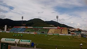
Ronaldão (stadium)
Distance: Approx. 4727 meters
Latitude and longitude: -21.77777778,-46.60583333
Ronaldão, also known as Estádio Dr. Ronaldo Junqueira, is a multi-purpose stadium located in Poços de Caldas, Brazil. It is used mostly for football matches and hosts the home matches of Associação Atlética Caldense and Poços de Caldas Futebol Clube.

Sul e Sudoeste de Minas (mesoregion)
Mesoregion in Southeast, Brazil
Distance: Approx. 59 meters
Latitude and longitude: -21.78777778,-46.56083333
Sul e Sudoeste de Minas (transl. South and Southwestern Minas) is one of the twelve mesoregions of the Brazilian state of Minas Gerais. It is composed of 146 municipalities distributed across 10 microregions.
Poços de Caldas Airport
Airport serving Poço de Caldas, Brazil
Distance: Approx. 6146 meters
Latitude and longitude: -21.8425,-46.56944444
Embaixador Walther Moreira Salles Airport (IATA: POO, ICAO: SBPC) is the airport serving Poços de Caldas, Brazil. It is named after Walter Moreira Salles, a banker and philanthropist. It is managed by contract by Infraero.
Weather in this IP's area
clear sky
12 Celsius
11 Celsius
12 Celsius
12 Celsius
1022 hPa
65 %
1022 hPa
886 hPa
10000 meters
1.23 m/s
1.91 m/s
93 degree
1 %
06:40:11
17:45:03