Country:
 Brazil
Region:
City:
Latitude and Longitude:
Time Zone:
Postal Code:
IP information under different IP Channel
ip-api
Country
Region
City
ASN
Time Zone
ISP
Blacklist
Proxy
Latitude
Longitude
Postal
Route
IPinfo
Country
Region
City
ASN
Time Zone
ISP
Blacklist
Proxy
Latitude
Longitude
Postal
Route
MaxMind
Country
Region
City
ASN
Time Zone
ISP
Blacklist
Proxy
Latitude
Longitude
Postal
Route
Luminati
Country
BRRegion
df
City
brasilia
ASN
Time Zone
America/Sao_Paulo
ISP
BR.Digital Provider
Latitude
Longitude
Postal
db-ip
Country
Region
City
ASN
Time Zone
ISP
Blacklist
Proxy
Latitude
Longitude
Postal
Route
ipdata
Country
Region
City
ASN
Time Zone
ISP
Blacklist
Proxy
Latitude
Longitude
Postal
Route
Popular places and events near this IP address
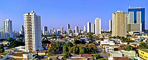
Goiânia
Capital city of Goiás, Brazil
Distance: Approx. 1381 meters
Latitude and longitude: -16.66666667,-49.25
Goiânia (; Portuguese pronunciation: [ɡojˈjɐniɐ]) is the capital and largest city of the Brazilian state of Goiás. With a population of 1,536,097, it is the second-largest city in the Central-West Region and the 10th-largest in the country. Its metropolitan area has a population of 2,890,418, making it the 12th-largest in Brazil.

Goiânia accident
1987 radioactive contamination incident in Brazil
Distance: Approx. 1171 meters
Latitude and longitude: -16.6746,-49.2641
The Goiânia accident [ɡojˈjɐniɐ] was a radioactive contamination accident that occurred on September 13, 1987, in Goiânia, Goiás, Brazil, after an unsecured radiotherapy source was stolen from an abandoned hospital site in the city. It was subsequently handled by many people, resulting in four deaths. About 112,000 people were examined for radioactive contamination and 249 of them were found to have been contaminated.

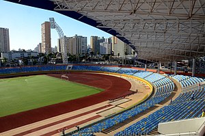
Estádio Serra Dourada
Football stadium in Goiânia, Goiás, Brazil
Distance: Approx. 3115 meters
Latitude and longitude: -16.69888889,-49.23388889
Estádio Serra Dourada is a football stadium inaugurated on March 9, 1975 in Goiânia, Goiás, Brazil. It was designed by the Pritzker Prize-winning Brazilian architect Paulo Mendes da Rocha. The stadium is owned by the Goiás state Government, and is the home ground of Goiás Esporte Clube.

Microregion of Goiânia
Microregion in Goiás, Brazil
Distance: Approx. 1381 meters
Latitude and longitude: -16.66666667,-49.25
The Goiânia Microregion is a region in central Goiás state, Brazil. It includes 17 municipalities with a population of 2,032,305 (2007) in a total area of 6,848.00 km2. The most important cities are Goiânia (1,244.645 inhabitants), Aparecida de Goiânia (475,303 inhabitants), and Trindade (97,491 inhabitants).
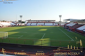
Estádio Antônio Accioly
Stadium in Goiânia, Brazil
Distance: Approx. 3368 meters
Latitude and longitude: -16.67020833,-49.28427222
Estádio Antônio Accioly is a multi-use stadium located in Goiânia, Brazil. It is used mostly for football matches and hosts the home matches of Atlético Clube Goianiense. The stadium has a maximum capacity of 12,500 people.
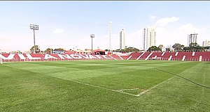
Estádio Onésio Brasileiro Alvarenga
Football stadium in Goiânia
Distance: Approx. 1810 meters
Latitude and longitude: -16.67355833,-49.237725
Estádio Onésio Brasileiro Alvarenga, also known as Estádio Vila Nova, or Estádio OBA, is a multi-use stadium located in Centro neighborhood, Goiânia, Brazil. It is used mostly for football matches and hosts the home matches of Vila Nova Futebol Clube. The stadium has a maximum capacity of 11,788 people.
Roman Catholic Archdiocese of Goiânia
Catholic ecclesiastical territory
Distance: Approx. 104 meters
Latitude and longitude: -16.6793,-49.2534
The Roman Catholic Archdiocese of Goiânia (Latin: Archidioecesis Goianiensis) is an archdiocese located in the city of Goiânia in Brazil.

Goiânia Arena
Gymnasium in Goiânia, Goiás
Distance: Approx. 3154 meters
Latitude and longitude: -16.69777778,-49.23222222
The Goiânia Arena is an indoor sporting multipurpose arena used mostly for volleyball that is located in Goiânia, Brazil. The capacity of the arena is 15,000 spectators for concerts and 11,333 for sports.

Greater Goiânia
Place in Brazil ----
Distance: Approx. 1381 meters
Latitude and longitude: -16.66666667,-49.25
The Goiânia metropolitan area (Portuguese: Região Metropolitana de Goiânia), popularly known as Greater Goiânia (Portuguese: Grande Goiânia), is a conurbation of cities around Goiânia, capital of the Brazilian state of Goiás.
Pontifical Catholic University of Goiás
Private research university in Goiânia, Brazil
Distance: Approx. 1069 meters
Latitude and longitude: -16.67805556,-49.24388889
The Pontifical Catholic University of Goiás (Portuguese: Pontifícia Universidade Católica de Goiás, PUC-Goiás) is a private and non-profit Pontifical catholic university, located in Goiânia (headquarters) and Ipameri, is the first university of the State of Goiás. It is maintained by the Catholic Archdiocese of Goiânia.
Estádio Olímpico Pedro Ludovico
Football stadium in Goiânia, Brazil
Distance: Approx. 1253 meters
Latitude and longitude: -16.67083333,-49.2625
Estádio Olímpico Pedro Ludovico is a stadium in Goiânia, Brazil. It has a capacity of 13,500 spectators. It is the home of Goiânia.
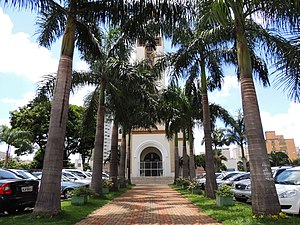
Our Lady Help of Christians Cathedral, Goiânia
Church in Goiânia, Brazil
Distance: Approx. 72 meters
Latitude and longitude: -16.6790744,-49.2535955
The Our Lady Help of Christians Cathedral (Portuguese: Catedral Metropolitana Nossa Senhora Auxiliadora) Also Goiânia Cathedral Is the name that receives a religious building that belongs to the Catholic Church and that is located in Goiânia, capital of the state of Goiás in Brazil. It is the seat of the Archdiocese of Goiânia (Archidioecesis Goianiensis), created by the bull Sanctissima Christi Voluntas by Pope Pius XII, on March 26, 1956. Don Fernando Gomes dos Santos, Archbishop of Goiânia, was one of the great promoters of The construction of the cathedral, which began as a chapel in 1937.
Weather in this IP's area
clear sky
28 Celsius
27 Celsius
28 Celsius
28 Celsius
1019 hPa
32 %
1019 hPa
935 hPa
10000 meters
4.63 m/s
70 degree
06:43:12
18:03:35