Country:
 Brazil
Region:
City:
Latitude and Longitude:
Time Zone:
Postal Code:
IP information under different IP Channel
ip-api
Country
Region
City
ASN
Time Zone
ISP
Blacklist
Proxy
Latitude
Longitude
Postal
Route
IPinfo
Country
Region
City
ASN
Time Zone
ISP
Blacklist
Proxy
Latitude
Longitude
Postal
Route
MaxMind
Country
Region
City
ASN
Time Zone
ISP
Blacklist
Proxy
Latitude
Longitude
Postal
Route
Luminati
Country
BRRegion
ms
City
corumba
ASN
Time Zone
America/Campo_Grande
ISP
BR.Digital Provider
Latitude
Longitude
Postal
db-ip
Country
Region
City
ASN
Time Zone
ISP
Blacklist
Proxy
Latitude
Longitude
Postal
Route
ipdata
Country
Region
City
ASN
Time Zone
ISP
Blacklist
Proxy
Latitude
Longitude
Postal
Route
Popular places and events near this IP address
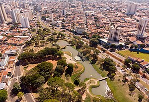
Bauru
Municipality in Southeast, Brazil
Distance: Approx. 100 meters
Latitude and longitude: -22.315,-49.06083333
Bauru (Portuguese pronunciation: [bawˈɾu]) is a Brazilian municipality in midwestern region of the state of São Paulo. It is the main city of the mesoregion and microregion of Bauru. The population is 379,297 (2020 est.) in an area of 667.68 km2.

Roman Catholic Diocese of Bauru
Catholic ecclesiastical territory
Distance: Approx. 1210 meters
Latitude and longitude: -22.3223,-49.0704
The Roman Catholic Diocese of Bauru (Latin: Dioecesis Bauruensis) is a diocese located in the Brazilian city of Bauru (São Paulo State) in the Ecclesiastical Province of the Roman Catholic Archdiocese of Botucatu in the city of Botucatu (also in São Paulo State).
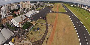
Bauru Airport
Airport
Distance: Approx. 3448 meters
Latitude and longitude: -22.345,-49.05388889
Comandante João Ribeiro de Barros Airport (IATA: BAU, ICAO: SBBU) is an airport serving Bauru, Brazil.
TV TEM Bauru
Television station in São Paulo, Brazil
Distance: Approx. 6359 meters
Latitude and longitude: -22.35988889,-49.09986111
TV TEM Bauru (channel 26) is a Brazilian television station based in Bauru, a city in the state of São Paulo, affiliated with TV Globo. It is owned-and-operated by Traffic Group as of 2003 under the TV TEM banner, which also owns three other stations under said name in the inland of São Paulo, and covers approximately 95 municipalities. Its studios are located in the Jardim Bela Vista neighborhood, and its transmission antenna is in the Jardim Ouro Verde neighborhood.
Weather in this IP's area
clear sky
33 Celsius
31 Celsius
32 Celsius
33 Celsius
1016 hPa
25 %
1016 hPa
957 hPa
10000 meters
5.14 m/s
350 degree
06:51:01
17:54:14